 |
| Sheep grazing in Escalante Canyon |

 |
| Rock art in Palmer Gulch |
 |
| Escalante Canyon |
 |
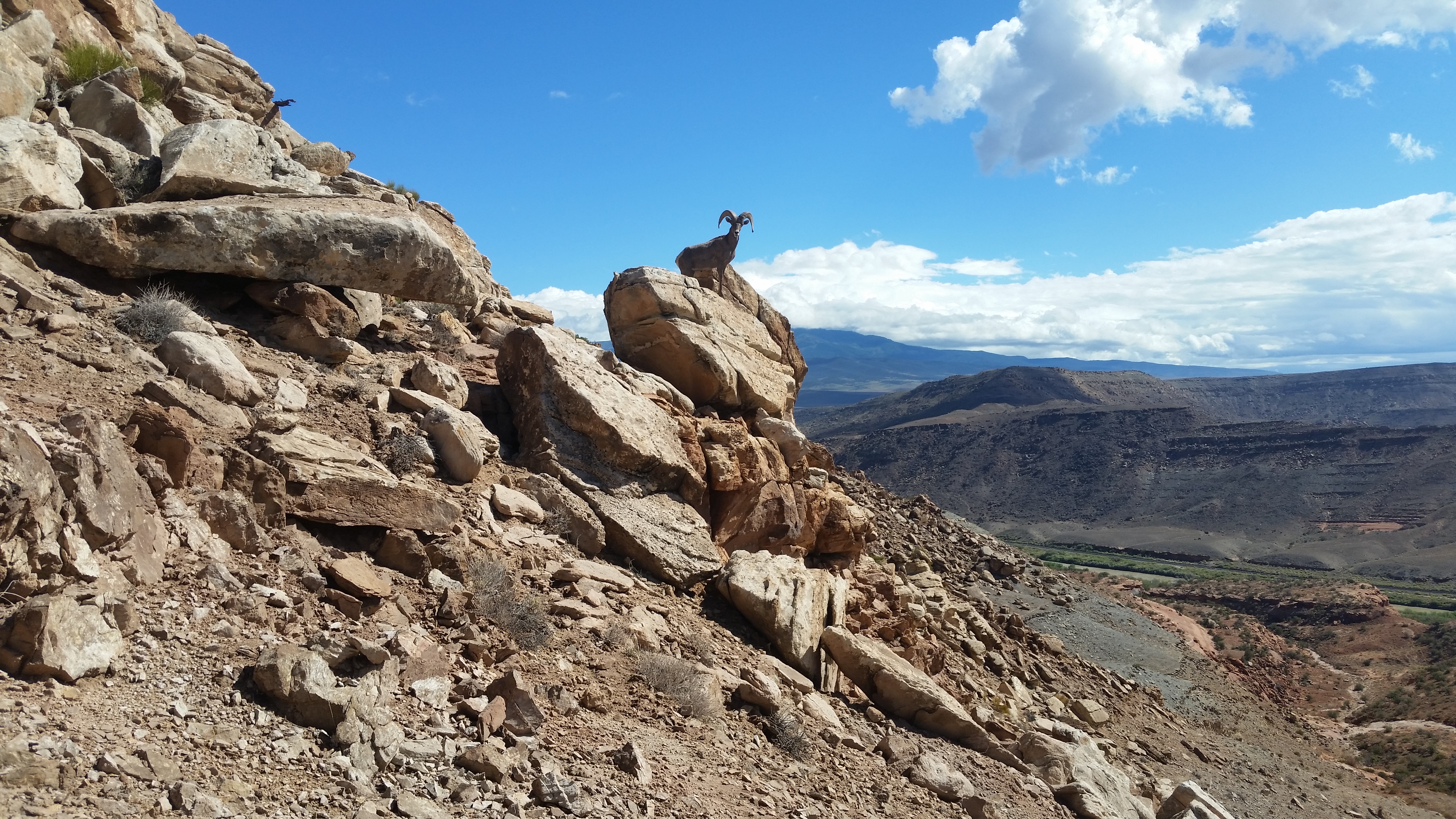
| Dominguez Canyon |
 |
| Dominguez Canyon |
 |
| Gunnison Rim |

 |
| Rock art in Triangle Canyon |
 |
| Triangle Canyon |
 |

 |
| Little Dominguez. The slide in the center can be used to ascend up to the left to peak 6012. Star Mesa is right side. |
 |
| Confluence of Little Dominguez and Big Dominguez |
 |
| Bangs Canyon |

 |
| The only submerged benchmark I've ever seen. |
⦁ The Natural Atlas app has a free version that shows the trails with mileages. The peakbagger app is better for other details and I posted some GPS tracks on it. I had no trouble wearing shorts on every hike. The area is infested with bighorn sheep that are losing their fear of humans. Posted 2022.
⦁ DOMINGUEZ CANYON has a popular trail running up it. The best hike is to go up canyon and take a trail up to the rim then come back over Triangle Mesa. The graded Bridgeport Rd leaves highway 50 at mp 52 and ends at the TH, just beyond restrooms. The trail goes over a mile along RR tracks and past an old bridge then across a new bridge then up the canyon. It goes past petroglyphs then in another hour there are more petroglyphs but heavily vandalized starting in 1858. At N38 48122, W108 26164 el 5650 there is a sign for the Cactus Park trail. I went up that to the rim el 6200 and it leads to the closed road on the topo that goes to Triangle Mesa. I stayed along the north side of the mesa until the road topped out then went up the west ridge. The last cliff band has a tricky move but not hard to go up. I walked to the far side then down at 49445, 24078 el 6150 and there I had two choices. One is a class 4 route. For that, head for an easy chute at 49606, 23454 el 5600 then down to the last rim at 49479, 23060 el 5100. A gully is in view below but to get in you have to walk another 250 feet on the rim then drop and come back to a huge boulder with two class 4 routes down along it, maybe each 10 feet high. That's risky without a rope so I backed up and walked a cow trail on the rim to 50359, 22974 el 4900 and then straight ahead another 100 feet there is a stock trail going down to the road along the river. It's a tenth mile on the road to the old bridge. Signs along there say private but the BLM map and caltopo say it's public. A BLM sign is nailed to the old bridge. That took 7 hours but the detour to the class 4 route might have taken an hour. The noticeable gain might be 1000. Posted 2022.
⦁ TRIANGLE CANYON is what I call the one on the north side of Triangle Mesa. It turned out to be the best canyon hike. I started at the Bridgeport TH and went over the saddle south of peak 5293. I crossed the old bridge on the river and went a tenth mile downstream where a stock trail goes up to the left. Private land signs along that tenth mile are in conflict with the maps. Nearly a fifth mile down from the bridge is a bigger sign that says Escalante Ranch No Trespassing and that is likely the real entrance to private land. The trail goes to a minor saddle then up to the left to the next level and it's easy to work up to the saddle. I went thru and stayed right then down to the lower canyon rim. I walked it to the mouth then dropped in and came back up the creekbed. When I got into the deeper gorge, I hit a major boulder jam that stops cattle. But hikers can go around the left side and stroll up a pristine canyon. I wanted to walk the south rim back and the first exit I saw is at N38 49867,W108 24405 el 5300. I walked past it to a left bend then took an easy angle up and rim walked to a trail at 50390, 23654 that took me back to the saddle then I retraced out. Nearly 5 hours with 600 noticeable gain. No running water. A loop could be done using the Dominguez Canyon trail. I would start in that canyon and go up to the Cactus Park trail then almost to Triangle Mesa before dropping into Triangle Canyon. Posted 2022.
⦁ STAR MESA el 6580 - a good loop can be done ascending a stock trail out of Little Dominguez and descending the west side. I started at the Bridgeport TH and walked up Little Dominguez and got on the right bank at N38 48969, W108 22518 where a trail shortcuts a bend then meets the old road. The road goes past a cabin to a slide at 47975, 22187 el 5000 where the stock trail goes up. At the top of the cliffs it bends lefts and fades at a plateau el 5800. Obvious routes go on up, but I wanted to walk the whole summit plateau so I went to the east end then up to a break at 47179, 22436 el 6200 then stayed right of center and soon was on top. I strolled on to the high point and could see in upper Poison Canyon a natural tunnel, a very rare formation. I went on to the far end of the plateau then dropped down at 48197, 23745 el 6350 and on down to a closed road. I went left on that then down a ridge at 48041, 23820 el 6100 and bottomed out at the last rim at 47952, 24061 el 5550. Rocks are stacked there to get down a minor drop but too tricky for a solo hiker. A 20 foot hand line would have got me down off a tree. But I went upstream on the rim for a fifth mile to a trail going down a slope to the creekbed. The canyon soon opens up and a trail runs on the left bank and meets the Dominguez Canyon trail which goes back to the start. 7 and a half hours, 1500 noticeable gain. Posted 2022.
⦁ McCARTY TH to BRIDGEPORT TH - a one way hike can be done using the McCarty Bench then to Leonards Basin and up that to point 6012 then point 5916 and down to the river trail. I went up the McCarty Trail to el 5250 where a road branches right. I walked that a few feet where it tops out then up to a trail at N38 44475, W108 16408 el 5350. It goes along McCarty Bench to 44821, 16479 el 5350 where it crosses above falls and goes around the corner then up along the left side of a drainage to el 5400 where the bench goes on easy for over a mile. I skirted a drainage at 45335, 17620 el 5450 then on to a ridge at 45875,17848 el 5300 that has a game trail dropping to Palmer Gulch. I followed the topo to the invisible Gunnison Trail to get into the saddle el 5200 west of peak 5301. A faint road goes along that level toward Leonards Basin and then there is a trail on the left bank where the basin narrows. It merges into the creekbed and I went up it to 46726, 20645 el 5200 then got on the right bank. It looks like a stock trail at first and is easy to go on up to the saddle el 5800 south of point 6012. I had the option to drop down and left some to get into Little Dominguez, but I was feeling chipper for an old coot so I went up left of center on a sheep trail to point 6012. Then I walked the west rim and down to a basin and up a drainage left of point 5905 and on to a reg at point 5916, the first sign of humanity I saw along the rim. For the descent, I used a crack at 49522, 22054 el 5850 then drifted left a little down an easy ridge to 49675, 22089 el 5400 and then straight down a broad slope. The last cliff band has a stairway at 50059, 22309 el 4850 then one more straight below it to get to the river trail. I had the luxury of a GPS track on peakbagger by Whiley Hall for the descent route. It took an hour along the river to get to Bridgeport TH. That took nearly 9 hours with about 2000 noticeable gain and mostly easy terrain. And it's the most unspoiled real estate I saw in the NCA. A bike can be used for the 16 mile shuttle because highway 50 has a wide shoulder. A solo hiker with a car and bike can set up camp along the Bridgeport Rd then leave a bike at that TH and drive around to McCarty and do the hike. Then the next day, ride over to retrieve the car. It took me 2 hours to ride a pedal bike. Posted 2022.
⦁ PEAK 6012, PEAK 5916 - I did these on the one way hike from McCarty TH but there is another option. Go up Little Dominguez and try the little canyon west of 6012. It has cliffs high up that can be passed by staying right. If that fails, there is a slide further up the main canyon, maybe 2/3 mile, that will work. I could see it from Star Mesa. That's the route I would choose and just make a loop over the peaks and down to the river. Posted 2022.
⦁ GUNNISON RIM - a pristine section of the lower rim can be walked one way from the Bridgeport Rd up upstream to the jeep trail near point 5243. I was camped on the Bridgeport Rd at a large camp area and walked from there. I left the road at N38 51148, W108 20962 el 4950 and followed very easy ground and ever so slightly gained elevation and came to the saddle el 5200 west of point 5372. Coming down that point would be another way to start this hike, but I wasn't camped up there. I dropped down to the 5050 level and easily walked along that. The only time I had to make a decision was at a spot el 5000 NW of point 5458. And I picked wrong. I went up to el 5100 but had to come back down in a draw. Staying along the 5000 line then up the draw should work better. I just followed rim the around to a basin below point 5243 then a little more to the jeep trail which is now OHV trail 78A. I walked up that to road #78 at point 5163. I had a bike there and coasted most of the way back to camp. The hiking part took 2 hours, 40 minutes with maybe 500 noticeable gain and not steep. This is one of the most pristine areas I saw in the NCA. I didn't even see cow shit in the basin below point 5243. How'd they miss it? Posted 2022.
⦁ DOMINGUEZ RIM - crude roads go all over this. At mp 58.3 on highway 50 there is a sign for Escalante Overlook. Westbound drivers have to go to mp 56.8 and come back. The high clearance road goes 2 miles to the rim. Left goes down to the Escalante Rd. Right goes to Palmer BM and then the road pulls away from the rim. The rim can be walked to peak 5454 and there is a game trail that drops down to a peninsula protruding from the rim. It would be easy to drop on down to the floor but I didn't see any point in that. Ebikes work on these roads and loops can be done using the highway because it has a wide paved shoulder. Posted 2022.
⦁ ESCALANTE Rd leaves highway 50 at mp 59.3. It goes graded nearly 3 miles to the river bridge. 2 miles beyond that is the McCarty TH. At mile 3.6 the Escalante Rim Rd goes left. At mile 8.4 the road enters a long stretch of public land. At mile 9.3 is Potholes Campground, no fee. At mile 12.4 is a stream, the best water I saw in the NCA, reading N38 39215, W108 22244. At mile 15 is a ford past Escalante Forks where I turned back. I could have drove a car to the ford. Posted 2022.
⦁ PALMER GULCH is blocked at the mouth by a ranch. The easiest way in is to buy the ranch. If that's not feasible, the McCarty Trail can be used to drop in off the rim then walk down canyon and out on the McCarty Bench. I dropped in at N38 43613, W108 18688 el 6240 and into a side canyon below falls. A game trail at 43805, 18936 el 5750 on the far bank leads to a large bench below point 6255. Walking the ridge down between the forks would be fastest, but I wanted to explore upstream. I walked the bench and dropped to the creekbed at 43846, 19769 in a maze of balancing rocks. I strolled on down the easy, dry creekbed to a main fork el 5200 where long trails go bank to bank on down to an easy ridge at 45752, 18411 el 5000. That ridge leads up to McCarty Bench. I walked it to 45589, 17661 el 5400 then on to where the bench fades and then a trail drops a little and goes around the corner and crosses a drainage just above falls. Descending along that drainage would likely work but I didn't have a shuttle. I stayed on the trail until I met the McCarty Trail then back. 7 hours, 18 minutes and 1500 noticeable gain. This is the best hike in the area only as long as cattle don't come back. They were thick years ago as far in as the bench below point 6255. There is an old tree fence running across Camp Ridge at el 6200. It shows on the sat image. It's the longest I've ever seen. Posted 2022.
⦁ BOYCE GULCH NORTH RIM LOOP - the McCarty Trail can be used to get to the rim then loop back by way of point 5935. Go up the trail to el 5300 and look up at point 5935. There is a drainage to the left that looks good for the descent at the end of the hike. Stay on the trail until close to the north rim of Boyce then just walk it to the rim of Escalante then on to a wash at 43903, 16629 near point 5935. It soon goes over a drop so move right a little then down and back to the trail at the 5360 line. Nearly 4 hours and 6 miles. Noticeable gain is 1000 feet and on the trail. Easy terrain. Posted 2022, 2025.
⦁ SOWBELLY MESA has an ancient trail dropping into Boyce Gulch. A good one way hike can be done by starting up the McCarty Trail. I walked that trail then veered off to a stairway at N38 42818, W108 19057 el 6300 that put me into upper Boyce. I went upstream and stayed left in the next fork and hit the north rim of Tatum Gulch at 42280, 19156 el 6300. I strolled the rim awhile then cut over to the ancient trail at 42855, 17621 el 6050. It angles down a tenth mile toward the road, then fades, so I dropped straight down a little and had no trouble getting below the cliffs and found the trail again. I stayed on the easy bench just below el 5600 using game trails and hit the real trail again at 42907, 17002 el 5450. It goes down a ridge to the creekbed then it's a half a mile to the mouth at the Escalante Rd. I had a bike there and coasted 2 miles back to the McCarty TH. 4 and a half hours and the only strain is the first 1000 feet gain up the McCarty Trail. Good pj forest. Posted 2022.
⦁ LITTLE MESA is a rarity because it still has 5 roadless miles. I made a loop up the Dry Mesa road then down Little Mesa. I parked at the petroglyphs el 5050 at the north end and walked the road to a fork el 5300. It's ebikeable to there. Left goes up Dry Fork and is not motorized. I stayed right to el 5950 then left the road and walked level on a faint trail for a quarter mile to a point at N38 40520, W108 17386 el 5950. I dropped there to the creekbed of Tatum Draw and strolled up to 40137, 18135 where I could easily go up to the mesa top south of point 6578. Then I had a super easy walk to point 6020 then descended on a spotty trail at 42382, 16110 el 5750 then to a stairway at 42503, 15589 el 5300 just above the start. 5 and a half hours, 1200 noticeable gain. 2 hours was road walking but that could be cut in half by riding an ebike to the fork in the road el 5300. Cattle were on the mesa years ago but where's the water? Posted 2022.
⦁ UNAWEEP CANYON WEST RIM - a one way hike works here. I coasted on my bike from camp near mp 149 on highway 141 down to a pullout at mp 151.7. A trail goes from there upstream along the cliff base and soon there is a class 2 sheep route going up and to the right and tops out on the rim south of point 5130. It's a ledge about 3 or 4 feet wide. I walked the rim to a canyon cutting thru with a descent route at N38 56096, W108 30148 el 5600. There is a route down by hugging the left wall to get past the boulders. I wanted a longer hike than that so I walked the low bank of the canyon until I merged into the creekbed. I went up that passing a multitude of deep holes where sheep get water. One had tadpoles. There is a minor fall at el 5800 that can be passed on the right in a crack. I kept going sometimes stepping up on the bank to pass a cluttered section then at el 6020 I exited up the left slope and hit the rim at el 6400. I strolled down that to a sheep route at 55313, 30574 el 5950. It goes down to the right then back left to a slide that goes the rest of the way down. I walked on to 55372, 30012 el 5450 then to camp. 5 hours and all the gain is super easy but for maybe 400 feet. This is a lot of pristine country to be so close to a major city. Posted 2022.
⦁ NINEMILE HILL EAST RIM - I walked one way from Cactus Park on the near pristine rim to point 5336 then on to an easy route down the west rim east of point 5247 on highway 141. The high clearance Cactus Park road leaves the highway at mp 145.2. I went 4 miles on it then left on road #31 for a fifth mile and parked. I walked up the road to where it goes hard right then went straight up to the mesa top and down to the east rim. I followed the topo and had a simple walk until one canyon that has a hard to find crossing. I dropped in at N38 54515, W108 28356 el 5700 then went downstream a few feet to an easy exit. I strolled on down to point 5336. Sheep hang out there and have a route down at the end of the point on the north side. I retraced back a little and crossed the next canyon at 55728, 27605 el 5300 and filled at a pothole there. I went up to the low north rim and found cairns. I followed those along the slickrock rim until I merged into the right fork of the canyon. I went higher there and on to another trail with cairns at 55659, 28594 el 5550. That soon leads to a main road and a road forks from there on the high ground toward the west rim and then I dropped left into a drainage. There is a class 2 route down the rim where the drainage pours off at 55961, 29091 el 5450 and it is bolted with a rope hanging down. It's overkill. I went down and stayed on the right side of the drainage and hit highway 141 at mp 149.3. That took 6 hours, 15 minutes with hardly any strenuous gain. Bikes can work for the 9 mile shuttle. The highway has no shoulder but traffic is light. Staying on the rim all the way down to point 4674 on the highway would work too. Posted 2022.
⦁ BANGS CANYON - I went up canyon staying left at main forks and came back on the Tabeguache Trail. That's a jeep trail that starts at mp 52.8 on highway 141. I walked it to the first switch where a foot trail goes left and that's better to get on the ridge. I went over the ridge then down the left side of a drainage on a game trail and on to the mouth of the canyon. That's private, but once in I looked up and saw a likely route on BLM land north of point 5066, at about N38 58612, W108 29144. A cow trail goes up canyon and there is a camp with an old stove at 57971, 30352 el 4900. At el 5000 the left bank has a trail and I stayed high to a trail at 57558, 31068 el 5100. That took me across to the west bank then I walked to a minor crossing at 57527, 31244 el 5200. I kept going south and merged back to the creekbed at a main fork NW of point 5690. I followed the south fork using the west bank and weaved back to the creekbed west of point 5690. I could look up and see a slickrock rim el 5600. I walked up a ridge to the right of it and topped out at a class 3 crack at 56719, 31359 el 5600. Then I rim walked to an easy crossing at 56162, 31319 el 5800. I was low on the rim for the last tenth mile to that. Then I loosely followed the 5800 line until I had a straight shot to the jeep trail north of point 5760 and it leads back. 6 and a half hours and the gain is super easy except for maybe 400. Cattle have been gone for years but the south fork will always be pristine. It's the main attraction with all the slickrock. Posted 2022.
⦁ GIBBLER MOUNTAIN el 7628 - a loop can be done over the peak then back in Farmers Canyon. A 4wd road runs between the two. Take the graded Dominguez Rd to el 7941 and turn NE for about 5 miles and park. It's a tedious road but cycles and ebikes can thread a lot of the bumps. Walk to the jeep trail that goes to the south ridge then go up and over the summit and down the north ridge. I went to a break at N38 50279, W108 30856 el 7050 then down to the flats and on to ATV trail #16 at 50428, 31637. That leads to a drainage south of peak 6927 and it goes down to the floor of Farmers. After checking out the big drop, walk the creekbed upstream and when it bends away from the east bank there is a game trail on the east bank to follow then just go back to the start. Nearly 5 hours with 700 noticeable gain. A lot of good pj forest especially on the summit. Cattle have been gone out of Farmers for years but if they come back I would skip it. It's starting to look natural again. The road goes on 5 miles to highway 141 but steeper. Posted 2022.
⦁ RIM TRAIL is a 4wd road near the Divide Forks Campground on the Uncompahgre Plateau. A car can make the Uranium Rd to el 8968 then ebike the rim road. It goes 6 miles to a TV transmitter near Plateau Benchmark. Take a TV and watch some football. Posted 2022.
 |
| The farmer in Farmers Canyon looks like a chef |