|
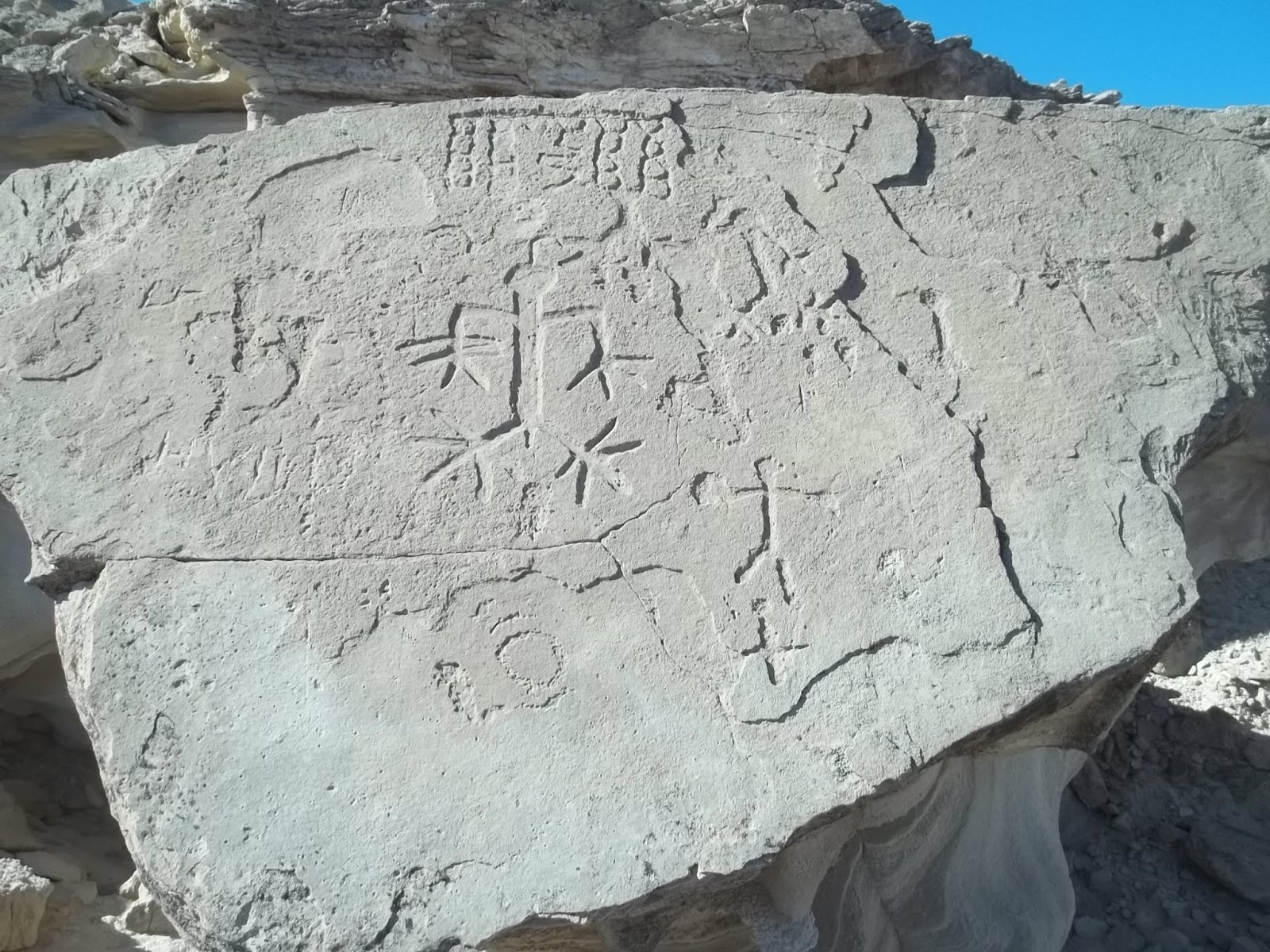
| Geoglyph at Tadpole Tank |
 |
| Thumb Peak |
 |
| Opal Hill Mine. That bus had 1979 plates. |
 |
| The Indian trail crossing the range at the south Flat Top, shown upper right. |
Palo Verde has gas and a couple of mini marts. Free camping is at the county park 2 miles south of town. Less than a mile south of that is a sign for Cibola Refuge. That road goes half a mile to fee campgrounds. At mp IMP 69 on highway 78 near Walters Camp Rd is where big RV camp areas start. Posted 2017.
- PALO VERDE PEAK el 1800 is the high point of the wilderness. Go south from Palo Verde town on 78 for over 5 miles to graded Stallard Rd at mp IMP 75.4. Take that road for 2 and a half miles to the dump. Go along the left side of the dump on easy 4wd. In a third mile is a fork where small rigs can camp. Take the left fork for over 4 miles and start hiking up a little rib at N33 20235, W114 46887 el 700. Head for the main north gully at 19933, 46648 el 1000. Go up that as it bends right and ends at the headwall el 1250. At the wall, go left along the base to the east side of the summit and circle up to the flag at 19766, 46627. No reg. 2 hrs, 1200 gain. Updated 2019.
- SHARKS TOOTH el 1463 is a crag a half mile south of Palo Verde Peak. A class 2 route goes up the SE gully. Take highway 78 to mp 70.2 and walk to high ground at N33 17599, W114 45435 el 350. Go up to a burro trail at 17907, 46157 el 450. It goes along a wash for .15 air mile then cuts thru a gap to the next wash. Go on up to a shortcut trail on the left bank at 18565, 46513 el 550 then go on to the SE gully at 19074, 46659 el 750. Follow it up to a high saddle then go left to the summit at 19279, 46808. 4 hours with 700 feet of strenuous gain. Burros have trashed all but the last half mile but it's still a pretty good hike. Posted 2019.
- MILPITAS WASH LOOP DRIVE - a 30+ mile loop can be done around the range with a 4wd and all the major peaks can be climbed on a long weekend. Take highway 78 to mp 68.6 and turn at the sign for Milpitas Wash. Go west for about 4 and a half miles to road #658. That's an easy 4wd road that goes for 3 and a half miles to access the southern Flat Top. Keep going west on the main road another 4 or 5 miles to road #706. That road goes nearly 3 miles and gets closest to the Flat Tops. The Milpitas road goes on to MILL BM on the left reading N33 23934, W114 55328 el 1150. Road #513 goes to the base of it. That's a half hour hike. TADPOLE PEAK el 1520 is what I call the high peak on the east side of the main road. Park at a bend and walk half a mile to a wash at the base reading 23664, 54081 el 850. Go up the wash then climb the ridge at 23467, 53923 el 950 and follow it all the way up to the reg at 23668, 53625. Rocks thin out at el 1100. That's a 2 hour hike. Back on the main road, a geoglyph is on the right at 23844, 54523. An Indian trail runs right by it and on to Tadpole Tank which is another half mile up the road. You could go scuba diving in that. RITT BM is next. Stay on the main road around to the north side of it then hike up a bad road #516 onto the ridgetop then walk on to the BM and reg at 25012, 55031 el 1150. That's a 1 hour hike. The Indian trail comes around the east tip of this little mountain. The main road will morph into the Wiley Well Rd and enter the Mule Mtns LTVA. An unsigned fork is there at 26957, 53560. Turn right and go nearly 2 miles to fork at 27195, 51997. Both go, but left is better. The Opal Hill Mine is a fifth mile on the right fork. Both forks soon merge and the road gets easy on out to Palo Verde town. The turnoff for the Thumb Peak hike is along the way. The road goes thru the front yard of a farm house just before town. Another option is to go south from the farm house for 3 miles to the dump. Then go right on road #569 and that goes to Milpitas Wash. The Lost Mine and Palo Verde Peak hikes are along that road. This loop is on the AAA map, but not the spur roads. Posted 2017.
- SAGUARO PEAK el 1534 is what I call a jagged peak about 2 miles west of Palo Verde Peak. A class 2 route goes up the west side. Take highway 78 to mp 68.6 and turn at the sign for Milpitas Wash. Go west for about a mile and a half to power lines then keep going another fifth mile and turn on a crude road. Go nearly 2 and a half miles to a wash and park. Walk up the wash using the left bank then go thru a gap at N33 19520, W114 48729 el 800 and go up to a main fork about half a mile before the peak. Go up the left fork to a game trail on the right bank at 20063, 49046 el 900. A lone saguaro can be seen up to the right. Follow the trail to the main west saddle el 1000. From the saddle, go up a drainage to el 1100 and then head for a narrow gully at 20329, 48971 el 1300. It's easier to pass below the gully at el 1150 then circle back up to it on stable ground. Go up the gully to a notch then go thru the notch and stroll up on easy ground to the SE side of the summit then go up to it. It reads 20316, 48921. For a loop back, go back down the gully and keep going down to the main wash and walk it down to 19626, 49381 el 800 where you exit left. Go across flats to a trail at 19434, 49149 el 800 then the rest is obvious. 3 hours, 800 gain. This is one of the better hikes. It's rocky, but usually not hard to weave thru on foot. The saguaro is the only one I saw in the range. Posted 2017.
- SOUTH FLAT TOP el 1600 has an easy route up the south ridge. Take highway 78 to mp IMP 68.6 and turn at the sign for Milpitas Wash. Go 4.4 miles to easy 4wd road #658 reading N33 17779, W114 50827. Take that for 3 and a half miles where rocks spoil the party in a wash el 850. Everything is stopped in another half mile. Walk up the wash to an Indian trail at 21138, 51034 el 1000. I was expecting to find a trail because I saw it at the Lost Mine TH. I knew they had to be cutting across the range to Tadpole Tank. From there it's easy to see how to go up the ridge to the summit. 3 hours with about 500 gain up the ridge. I walked the trail east for a third mile and it vanishes in a wash. Posted 2017.
- NORTH FLAT TOP el 1500+ sits in the middle of the wilderness. A 4wd road comes in from the south as the topo shows. Take highway 78 to mp IMP 68.6 and turn at the sign for Milpitas Wash. Go 9 miles then turn on road #706 reading N33 20083, W114 53958. A rocky crossing about a mile in is the worst spot on 706, but mtn bikes would work for the remaining road. I never saw a closure on 706 so I kept going nearly 2 more miles to a washout el 850 that stops everything. It's another half mile on the road to a foundation then the road dips into a wash with a dry well pipe. Keep going a few more feet to a game trail at 21882, 51887 el 950 that goes up a right fork in the wash and into the main saddle el 1000 between the two Flat Tops. Turn left and go up the ridge to the northern Flat Top. The ridge is easier than it looks. An ocotillo garden and carpet of rocks is on top. It's just one layer embedded in light colored soil, not hard to walk on but slow. It takes 20 minutes to walk the half mile across to the northern tip. Someone cleared a circle at 22544, 52088 then it's just another 500 feet to the tip where there's a good rock to sit on. That took me 3 hours with about 500 gain up the peak. I did the south Flat Top as a separate hike up the south ridge because the NW slopes are the most miserable rocky mess I have ever seen, but I found out in 2019 that going up directly from the main saddle isn't loose rock. But the north ridge is another option. From the main saddle el 1000 between the Flat Tops, go down a deer trail then up another one at 22199, 51444 el 1000 that goes up along a drainage then tops out on the north ridge el 1150. That ridge looked OK, but I kept going along the east base of the peak. I went down from the north ridge to the main wash and walked a trail on the left bank. I came upon a 3 foot deep waterhole at 21795, 50898 el 950. It's best to cross to the trail on the right bank just before reaching the waterhole. I saw a deer there. It was easy to walk along the trail at the base of the peak all the way to the Indian trail on the south side at 21137, 51036 el 950. That trail goes SW along a wash, switching bank to bank. At 20781, 52227 el 800 it dips into the wash then goes about 400 feet then exits on the right bank and soon makes the turn toward Tadpole Tank. It fades out along here but it's easy to walk the flats back to the start. It took me 2 and a half hours to walk that leg of the hike from the main saddle back to the start. If I hiked up the north Flat Top and came back the Indian trail route, it would take me under 5 hours. Good scenery. Anyone walking back on the Indian trail should not drive more than 2 miles in from the Milpitas Wash road on road #706. The Milpitas Wash road is graded but too soft to risk a 2wd. Posted 2017.
- FLAT TOPS INDIAN TRAILS LOOP - trails can be used to circle around both Flat Tops. Take highway 78 to mp IMP 68.6 and turn at the sign for Milpitas Wash. Go 9 miles then turn on road #706 reading N33 20083, W114 53958. Drive a mile and a half then walk to a wash at N33 21055, W114 53415 el 750. Go up that then exit left at 21563, 53314 el 800. Then weave thru rocks to a ridge at 22064, 53335 el 850. Go up that for 3/4 mile and a trail starts appearing in a rock field. Walk it to 22525, 52593 el 900 and down a canyon to sleeping circles where it veers right and gets spotty along a major wash. It goes steep up the right bank but it's just as good to stay in the wash then exit on a faint trail at 23458, 51728 el 700 and go on to another trail at 23306, 51293 el 750. Go up a canyon on that and it fades in the creekbed then use the left bank at 23016, 51356 el 750 and walk a smooth channel. When that plays out cross to the right bank where there is a rock arrow. We dropped to a lower bank there then soon came back up to the high bank and kept going up canyon on faint trails bank to bank. At the head of the canyon, the main trail circles to the right to the saddle el 1000 between the Flat Tops for anyone wanting to climb the peaks. To skip them, go left up a game trail at 22199, 51444 el 1000 that goes up along a drainage then tops out at a saddle el 1150 on the north ridge of the southern Flat Top. Go down from the north ridge to the main wash and walk a trail on the left bank. A 3 foot deep waterhole is at 21795, 50898 el 950. It's best to cross to the trail on the right bank just before reaching the waterhole. It's easy to walk along the trail at the base of the peak all the way to the Indian trail on the south side at 21137, 51036 el 950. That trail goes SW along a rocky wash, switching bank to bank. At 20754, 52307 el 800, it exits on the right bank and soon makes the turn toward Tadpole Tank. It fades out along here but it's easy to walk the flats back to the start. The loop should take 5 hours with hardly any strenous gain. Vic Hanson and I opted to climb the peaks from the main saddle in between. We went up to the north one then came back to the saddle and went directly up from there to the south one and didn't have any backsliding but it goes parabolic. Peakbagger.com shows the south Flat Top at 21720, 51439. We stayed on the main easiest ridge going generally south to get down to the trail. The hike took us 7 hours with 1200 rocky gain added for the peaks. This is the best hike on this page, largely because burros can't make it that far and stink it up. Posted 2019.
- LITTLE FLAT TOP el 1397 is what I call the smallest of the three. A loop can be done on the east side. Take highway 78 to mp IMP 75.4 and turn on graded Stallard Rd. Go 2 and a half miles to a dump then go left on road #569. Go a quarter mile then take a right fork up a wash for over a mile to power lines. Go right along the lines for .4 mile to a major wash at N33 23399, W114 46361. Drive a mile up that then walk because boulders soon block everything. A guzzler is 1.6 air miles up the wash from the lines. Leave the wash there and aim for another wash at 22700, 48261 el 500. Walk the left bank on deer trails and stay on the low ground to 22496, 48703 el 600 where the trail drops into a wash. Go up that and into a fork at 22313, 48971 el 650. That fork leads to an old road in a tenth mile. Walk that into a major wash. The road goes back and forth across it but it pays to stay in the wash. Exit the wash at 21698, 50086 el 850 and follow game trails on the low ground to a minor wash at 21580, 50588 el 1000. Go down that a tenth mile then exit left thru a minor saddle then you're in the wash running along the southern Flat Top. A water hole in the wash at 21795, 50898 el 950 was 2 feet deep that day. A trail runs on down along the wash on the east side of the Little Flat Top for anyone wanting to skip the peak. Vic and I decided to go over the peak. We went up the south ridge at 22091, 51243 el 1100 then soon hit a short, crumbly looking knife edge. I let him go first to test it. I can replace him, but I can't replace me. It turned out to be stable and class 3 or less. We went over the summit then down at 22457, 51225 el 1350 where rocks were thinner. We hit the wash and got on the left bank trail at 22625, 50770 el 800. That is likely an Indian trail because plants growing on it indicate it's too old to be a burro trail, though a few burros have used it. We walked the trail over a mile then we took another trail at 22963, 49543 el 650. That one disappeared in a wash and we got on the right bank at 23010, 48594 el 550 then that fizzled and we got on the right bank again and stayed on the high ground back to the start. That took us about 5 hours with the 450 feet up the peak being the only strenuous gain but the peak can be skipped. By "skipped" I mean bypassed, not hopping on one foot. This is easily the second best hike on this page. Posted 2019.
- THUMB PEAK el 1375 has an interesting route up the east side. From the town of Palo Verde, go west on Palo Verde Rd for about half a mile to a tricky fork at a farm house. The correct road continues west along the south side of the house and on to the west edge of the fields. Then go right a tenth mile then left up a wash to the top of the bench. Stay on the main road for nearly 6 miles in from the farm fields then go left. The reading there is N33 26599, W114 50164. Go another 2 miles to the end of the legal road el 550 and park. An Indian trail can be seen along the last third mile of the road. That trail can be used to walk along side the road for 20 minutes to Clapp Spring. Then stay on the road (or a trail down to the right of it ) past the spring to a wide valley then go up along the east side of the peak and up the main drainage. Stay on the left side of the drainage until about el 900 then it's easy to angle up to the right side into a wide gully reading 24324, 51925 el 1100. The rest is obvious. Go up to the end of the gully then up a chute to a wide shelf. Then angle up to the right to top out on the summit ridge reading 24347, 51970 el 1300. Now there is a short stretch of knife edge but it's wide enough to be safe and then it's just a few more feet to the reg on the summit. 3 hours with about 700 gain that matters. Not for the squeamish. The spring was dry in 2017 even after big rains, but some big potholes were at the base of the peak reading 24401, 51718 el 700. The spring had a puddle in 2009. Mtn bikes would work on the road in except for the wash that climbs onto the bench. Posted 2107.
- LOST MINE LOOP - a mine tucked away on the north side of the range makes a good hike using washed out roads. Take highway 78 to mp IMP 75.4 and turn on graded Stallard Rd. Go 2 and a half miles to a dump then go left on road #569. Go a quarter mile then take a right fork up a wash for over a mile to power lines. Go left to the next tower where road #568 forks right reading N33 22985, W114 46415. Take that road for a mile to the legal end at a barrier el 500. Mtn bikes would have a mile of wash to deal with to get to the barrier. Everybody drives around the barrier, but that won't help anyone who is hiking the loop. Walk past the barrier a tenth mile where a faint Indian trail forks right. The trail goes to the same place as the road, just better for walking. Follow it into the main wash at 22094, 48106 then use the right bank (which strangely has no trail) and go on up that along the wash until you meet the road again. The bank starts to get hilly so it's better to walk the wash. Drop in at 22174, 48748. The road goes back and forth across it but it's best to stay in the wash. The wash circles to the south to the mine. Some tunnels, minor structures and a 1940s car are there. These mines are more like caverns with their skylights 100 feet up. To return, get on a road at the far side of the mine reading 20874, 49517 el 1000. About 200 feet down the road is another major mine on the left bank.The road has a deep trench down the middle then it bottoms out in a wash. It pays to use the left bank at 21438, 48896 el 750. When that fades, get on the right bank where a road goes back to the start. This easy loop of about 8 miles takes 3 or 4 hours. Nice colors. The Indian trail goes on across the range to Tadpole Tank. Posted 2017.
- SLOT CANYON - a good slot about a third mile long sits right next to highway 78. Drive to N33 18707, W114 44264 then turn up a wash for half a mile to the slot. A left fork has a trail that can be used to walk the south rim and drop in at 18774, 44972 el 300. I went a short way down to a class 3 drop about 8 feet high and pool which is normally dry. One way to make a loop hike is to stay on the south rim trail to a fork at 18604, 45592 el 450. Follow that west across a wash then it turns north and eventually into a deep wash that goes back to the slot. In 2019, we went all the way thru the slot with no rope needed. Another canyon is at mp 74.5. There is a deep waterhole .7 air mile up that, the deepest I saw in the wilderness. A trail is on the left bank about half way along. Vic Hanson found that water on one of his walks. Updated 2019.
- RVer's LOOP HIKE - an RV camp area is on the west side of highway 78 at mp IMP 68.8, right at the junction with Walters Camp Rd. A good loop can be done. Start on the west end on a rough track reading N33 17085, W114 46827 el 450. Walk that west until it fades out in gullies then keep going to the power lines which are on the Old Palo Verde Rd. Walk north on that road and go up a side canyon at 18786, 47345 el 650. Some potholes in this canyon had a lot of water. A trail goes on up east thru the main gap el 800 with some colorful rock then down a wash toward the highway. Exit the wash on the right bank at 18001, 46257 el 500 and into the next wash. Walk along that wash on a left bank trail for a quarter mile then go right on a trail then stay on the low ground for the home stretch. I drifted left to get to some odd bedrock at 17607, 46152 el 400. A trail goes from the upper end of that bedrock back to the start. For the last third mile I got off the trail and walked flatter ground to the left. That took 3 hours, easy. I dreamed this up to kill time waiting for football to start, but it turned out pretty good. At camp, I could pick up all 4 TV networks. An AT&T tower is in sight, but I couldn't get a decent VZ signal, not even in Palo Verde town. Posted 2017.
- PEAK 1320 is another hike that can be done from the RV parking areas near mp 69. It's a dominant peak a mile and a half south of Palo Verde Peak. Walk to N33 17307, W114 46647 then on to a wash at 17657, 46246. Use a trail on the left bank and stay on the low ground to a flat at 17900, 46351 el 500. Keep going toward the peak and enter the main east canyon where there is usually a left bank with a trail to walk on until it turns west and steepens. Go up to a shelf on the left at 18459, 46899 el 1150 then circle up the east side to the summit at 18423, 46925. 3 hours with 700 noticeable gain. Posted 2019.
- MOUNTAIN BIKE RIDE - a jeep road NE of Palo Verde Peak makes a good ride. Take highway 78 to graded Stallard Rd at mp IMP 75.4. Go .4 mile on that to road #207. Ride that a half mile to a fork. The right fork ends in half a mile on a steep hill. The left fork is the better one as it goes easy for nearly 2 miles along an Indian trail. This road is on the topo. Posted 2017.
 |
| Flat Tops Indian trail |
 |
| Sharks Tooth |
 |
| Lost Mine |
 |
| That car has a removable roof. |