Monday, November 26, 2018

Death Valley, east side

Tunnel near the Graham Mine

Graham Mine camp

Moorehouse Mine


The Wonder Mine. The main wonder is how they built a road up there.

A clue in the photo reveals that this started out in life as a car or truck engine.


  • IBEX BENCHMARK el 2557 has an easy north ridge. An Indian trail goes thru the north saddle. I parked on the highway at mp 39.2 and got on the trail at 45963, 19487 and on to 45881, 19640 then it fades for a mile and reappears at 45205, 20596 and goes a fifth mile to the saddle. Then it's an easy ridge until the last bit where I angled right on stable slopes to the west ridge then up. 4 hours, 800 noticeable  gain. Posted 2023.
  • OOREHOUSE MINE has some old trails. Turn off highway 127 at mp SBD 39.6. Go north about 3 miles to a fork, then keep right for over 2 miles to the mine camp at Ibex Spring. Take the road around the west side of the camp and park at fork at N35 46549, W116 24982 el 1250. There is a camp spot a tenth mile before the fork. The road this far is easy 4wd except for one tricky gully crossing where a bridge washed out decades ago, but it was easy that day. The right fork ends at the mine in a third mile, but that's the return route. Hike the eroded left fork up into a main saddle el 1500 which is to the left of white tailings. Now you can see a trail to the left going along the ridge. Take that trail and soon it drops into a bright canyon draining west to the big valley. It soon goes along the left slope as it drops down to some diggings then on to the main valley. Now turn north up the valley for a fifth mile to a large wash that goes back to the main saddle. Go up the wash to a trail on the left bank at 46822, 25288 el 1450 that goes to the saddle. It's worth it to go up the white tailings from the saddle to the main mine then down the road back to the start. 2 or 3 hours, not steep. One good side trip is the WONDER MINE. After dropping into the big valley, aim for a smooth bench at 47525, 26082 then walk that to a trail at 47892, 25856. Go left on that a short way to the eroded road that goes up canyon to the mine at 48363, 24640 el 2400. The road will fade in the creekbed then reappear again on the left bank just before the mine. A trail at 48382, 24637 el 2500 goes up 100 feet to the mine stuff. On the way out, I dropped left off the road at the canyon mouth and walked the creekbed. Two minor falls were easy to pass on the right, then I went on to the trail and followed it back along the base and into the main wash that goes to the white tailings. This side trip will take 3 hours, not steep. Posted 2018.
    • MCLAIN BM el 4300 is near Ibex Pass. Take highway 127 to mp INYO .50 then go west on easy 4wd for about 3 miles to a canyon mouth. Stay right at one tricky fork. Hike the mine road into the mouth reading N35 49249, W116 23052 el 2800. Follow  the road to the end at the Comet Mine el 3700. Now you have to get on the ridge next to the mine. I had to drop down some tailings on the north side to get on a slope to the top. Then walk the easy ridge. About a half mile before the peak there is a bump in the way. Walk left around it into a major saddle el 4000 then up to the BM at 50051, 24145. I went back down to the major saddle then dropped down into the canyon that goes back to the start. One minor fall is easily passed on the right. 3 hours, 1500 gain. Posted 2015. In 2020, I returned by a better route. I walked south from the summit on the main ridge for 3/4 mile to peak 1281 meters which I call Mammoth Peak. A 30 foot rock circle is there with an inner rectangle. Don't let it get disturbed as it might be of Indian origin. I descended the east ridge reading 49426, 24062 el 4150. At a saddle el 3600 a crag got in the way so I dropped down to the right and hit a mine road then walked south past the Mammoth Mine and out to the flats and back to the start. That version took 4 hours. Posted 2020. 
    • GLADSTONE MINE is in the middle of the Ibex Wilderness. A loop can be done from the Eclipse Mine because it has the only legal road for access. Turn off higway 127 at mp INYO 5.5 and follow easy 4wd along the left side of a quarry. It goes 5 miles then turns bad at a white mine. I parked there and walked to a cairn on a minor ridge at N35 50558, W116 22997 el 3000. I went up the ridge then moved left near the top to get over the rim then down to an easy wash. I went up that and got on the right rim at 50582, 23448 el 3350 then on to a saddle at 50689, 23556 el 3400 where I could see a road below. I walked up the road to a fork el 3650. Left goes to mines, but I stayed right thru a white saddle and followed the road to a white mine at the end. I dropped down a main wash there and came to a narrows with a minor class 3 drop. After that I came to harder drops. The right rim passes it all, but it's more scenic to go up to a saddle on the left at 51440, 24029 el 3250 and drop into the next fork and stroll on thru the narrows. It opens up and I came to rock house ruins on the left bank. A few feet more there is a side canyon. The right rim of that is a route to the Gladstone Mine but too rocky, so it's preferable to go on down to a wash at 51552, 23299 that leads to the road to the mine. It tops out at a divide where I went down the main wash and got back on the road at 51964, 23282 and on to the mine at the end. A 3 room ruin is next to the road then rock house ruins sit on a hand built road that ends in another 200 feet at a tunnel. I retraced back out on the road to a main wash at 51363, 23018 el 2750. I went a third mile up that to a main fork then left for a third mile where there is an option to go left for a shortcut but it's too rough. It's better to stay straight back to the minor ridge with the cairn near the start. 5 hours with hardly any strenuous gain. Posted 2020, 2022.
    • IBEX PEAK el 4750 is the high point of the Ibex Hills. Take highway 178 to mp 30.8 and turn on a crude  road. Go a mile and a quarter to a wash el 3000 with closed signs. Walk up that to a road at N35 53752, W116 26525 el 3150 then go up that for 2/3 air mile to a fork el 3450. Go right into a wash then go up the main bed for half an air mile where the road exits up the left bank. There's a better road another 100 feet up the wash. It merges with the other one and tops out in a saddle el 3900. Then go up the ridge and stay left around a bump just before the summit. The reg is at 52726, 25006.  3 hours, 1800 gain. The road ends in half a mile at a camp with a view. Posted 2017.
    • IBEX PEAK EAST APPROACH - the most scenic route for this peak is to go west up the canyon to Sheephead Spring then over the peak and down the east ridge. Turn off higway 127 at mp 9.6 and go 5 miles on the graded Furnace Wash Rd and set up camp at a point. Then drive to mp 5.5 on highway 127 and follow easy 4wd for 2 and a half miles to a small hill. Park there then ride a bike for a dozen miles back to camp and do the hike the next day. Walk the flats to a wash at N35 54284, W116 22165 and it leads to the spring. A narrows at the 840 meter line has minor falls that stop 4 wheelers. Somebody drove all the way up there to find out the hard way. At the spring there is a trail that goes up on the right bank at 54040, 24417 then it's an easy ridge to a drainage at 53309, 25010. Go up that to a saddle at the end then on up the ridge to 52869, 24952 el 4650. Level off there along the left side of a bump then the peak is next where the easy descent ridge is obvious. Then drop to the south saddle and go a few feet more to the easy ridge at 52569, 24914. Go down to a saddle el 3750 at a bright hill then left down an easy ridge and hit a main wash between cliffs at 52667, 24176. A half mile down the wash is a short narrows. Go thru and a few feet more is steep route up the right bank. Go over and drift left down a ridge and it will split. Stay left into the canyon and walk it out. 7 and a half hours, 3000 gain but nearly half is up the easy wash. The app said 13 miles. The spring had a tiny flow and tamarisk had been cut down. Backpackers could use it but take a pocket saw to clear out tamarisk that is growing back. Sheep use this so give them room. I saw one. This is the best hike in the Ibex Wilderness. I put a track on peakbagger under Bob G. Posted Nov 2022
    • SHEEPHEAD MOUNTAIN el 4275 - a loop can be done by way of Salsberry Spring. Take highway 178 to a pullout next to a downhill sign at mp 31.4. It's a half mile south of Salsberry Pass. Walk south on the road for 200 feet then get on the south bank of a deep gully and walk uphill for over a tenth mile and merge with an old road. Walk that into a canyon and go up that and soon it's obvious how to go up the ridge to the reg at N35 55200, W116 24615. Then walk the crest on a sheep trail for nearly half a mile and walk left around some crags into a deep saddle el 3800. A peak is in the way here, so walk around the left side of it going slightly downhill and on into a broad drainage then up along the left side of that to a ridgetop el 3900. Walk that to 55640, 25024 el 3900 then go down a ridge there to 55771, 25030 el 3650 where the route down to the spring is in view. It was dry, but had a stream years earlier. Then walk down the canyon a quarter mile and cut left thru a mine camp at 55986, 25308 el 3150 to get back to the pass where you left a mountain bike. A second car could be left at mp 33. The loop took me 3 hours with about 1500 gain and I had no shuttle at all. Posted November, 2017.
    • SHEEPHEAD MOUNTAIN CIRCUMNAVIGATION - this is an easy one that just needs a topo on a phone. I parked along the highway near point 868 meters and walked up Bradbury Wash to Sheephead Pass then moved right to get down the other side on a ridge into a canyon. It has some class 2 drops then when I was passing north of peak 951 I went left over the rim and on to a nameless spring. It's best to circle right then go up the drainage to it. It's only a dry clump of mesquite. I walked the base on to the highway near peak 949 then rode a pedal bike 4 miles back to the start. 3 and a half hours for the hike and the bike ride was the only strenuous part. An ebike would make it easy but that's cheating. Good color, easy terrain, nearly pristine. Posted 2022.
    • SALSBERRY PEAK el 4250+ makes for a good loop by way of Montgomery Spring. Take highway 178 to mp 34 and leave a car or bike there then drive over Salsberry Pass and park at mp 30 el 2800. Walk to a minor wash at N35 55357, W116 27486 el 2850 and follow along that on the low ground to a wide wash at 55776, 27551 el 3050. Follow that up to the east saddle at 56738, 27183 el 3950. About 500 feet before the saddle it's easier to climb up out of the creekbed and walk along the right slope into the saddle. A sheep trail goes up the ridge to the summit area where crags are easy to weave thru. The reg is at the south end. Retrace to the saddle and follow a sheep trail to get down into the canyon and walk to a sheep trail on the right bank at 56877, 26942 el 3500. It leads around the corner to a small cave containing the spring. It's a clear puddle with several drips into it and likely perennial. Go on down the canyon and exit on the right at 56972, 26638 el 3300. Keep going at that level for 400 feet to the next little ridge and go down that then it's obvious back to the highway. I went down the little ridge for 2/3 mile then cut thru a gap at 56774, 25548 el 2900 to get to my bike at mp 33. That loop took me 4 hours and there was only about 500 feet of gain that wasn't very easy. It's easiest to start at mp 30 for anyone wanting to go up and back the same way. Posted November, 2017.In 2019 I did the loop without a shuttle. I parked at mp 31.4 and dropped into a wash and walked down to 54751, 27056 where I cut over to the minor wash el 2850 and merged with the other route. That only took 4 and a half hours.
    • EPAULET PEAK el 4765 - a loop can be made from Rhodes Spring to the NE ridge. Take the Badwater Rd to mp 54.2 and turn on easy 4wd. Stay left at a fork in a few feet then go on a mile to the end of the road at the spring el 1900, which is a hole with rough looking water. Hike NE up the valley to N35 56375, W116 20375 el 2300 then on to a canyon at 57405, 29895 el 2700. Go up canyon to a main fork at 58144, 30077 el 3000. Go left and stay right at main forks just past there in order to stay in the main wash. It bends left at 58557, 30258 el 3300 and goes up to a saddle on the NE ridge next to peak 1218 meters, reading 58757, 30714 el 3900. Go up the ridge right of center to skirt some outcrops then comes the final slope which is not nearly as rocky as it looks. A third mile before the summit, move left to skirt rocks. The reg is at 58365, 31466 in a plastic jar that won't last. It's obvious how to walk west on the main ridge for half an air mile and descend a bright ridge. I could see how I could drop to the right off the bright ridge into an easy canyon, but I had to be a hero and dropped into the canyon on the left side at a gully reading 58012, 31909 el 3350. Then I had two minor falls to skirt on their left side in that canyon. No big deal but the other canyon looked easier. Either way, once down at the flats get on a mine trail at 56265, 32672 el 2000. It goes over a saddle then down a wash and resumes at the flats and goes back to the start. 6 hours with nearly 3000 gain, but only 200 could be called steep. Top notch scenery. Sheep had just been in the descent canyon. The north side roads are closed, but that side is extremely boring anyway. I pity the hikers that walk in that way. A hiker using a phone with topo map on it wouldn't need hardly any coordinates. The route is obvious on the map. Posted 2018.
    • GRAHAM MINE TRAIL - miners laid out an easy trail from Rhodes Spring to the mine.  Take the Badwater Rd to mp 54.2 and turn on easy 4wd. Stay left at a fork in a few feet then go .6 mile and park. This road is mtn bikeable. Walk the flats to N35 55918, W116 32179 el 1800 where the trail is dipping into a major wash. Go NW up the wash for .3 mile where the trail exits up the right bank and goes thru a low saddle el 2000 then on to a valley where I lost it. I found it again at 56539, 32874 el 2000 where it crosses a low ridge into the next canyon where sheep had been hanging around. Go up canyon to a trail on the left bank at 57966, 33437 el 2850 that skirts minor falls then follow the main wash to a fork at 58485, 33185 el 3300. The right fork goes for 3 minutes to a clean tunnel in solid rock on the left bank. The left fork goes 300 feet to a mine camp el 3400. A trail goes up from there to the Graham Mine at 58660, 33346 el 3700, a bottomless shaft. It's only a short way up to a good view and the energetic could keep going to Epaulet Peak. 5 hours and only the last 300 feet of gain gets steep. It would be the same mileage to hike directly up from the highway, but very monotonous. Anyone starting at the spring could pick up the trail at 55875, 31649 el 1850 then 55924, 31853 el 1900 then on to the major wash. No one had walked this in decades, but someone started to fence off the shaft but stopped.  A heavy metal object is on the flats at 55795, 32001. Posted 2018.
    • For the DESERT HOUND TRAIL, drive to mp 50.1 on the Badwater road in southern Death Valley. Turn on a primitive road and go nearly a mile and a half to the end. Head for a bench at N35 56012, W116 34725  keeping to the left of a rock field. Go on up canyon to 57273, 34913 which is the trail to Virgin Spring. But go up the wash to the right of the trail to 57289, 35034 where you go up the slope on the right and pick up the Desert Hound Trail which is not far above. Follow this as it goes along the right slope of the wash and up into a saddle. Keep going up the ridge and you'll hit the trail soon again. At about 3100 feet ignore a spur trail going left and don't be tricked by it on the way down. The trail eventually drops into a wash. Get on it again on the other side at 57784, 36062. Soon it drops into another wash then exits on the left about 200 feet upstream. It soon fades so head for 57802, 36300 where it goes up steeply then veers left to the right of a big cairn. Now it goes along on the level to a minor saddle at 57914, 36522 and then on to a wash nearly 200 feet deep. The trail goes down the nose to the left then fades. Go on down and across the deep wash to a saddle on the far side at 58062, 36925. This is where you join the upper trail. Go left to the DESERT HOUND MINE at 57975, 37557 el 3900. Old artifacts here include a Coleman type stove. More stuff is further along. On the way back, detour over to the spring at 57217, 35122 and walk out on the right side trail back to the main Virgin wash. About 7 hours for the whole trip and about 3000 gain. A hiking book says you get all scratched up but I had no trouble. DESERT HOUND PEAK makes a good side trip. Use the main gully before the mine to get at it.
    • BROWN PEAK el 4947 - a loop can be done going up the standard west route then down the SW ridge. Take highway 127 to mp INYO 34.3 at N36 12592, W116 23366 and turn on an easy 4wd road. Go 7 miles on that and park. I parked at a camp spot reading N36 07338, W116 25851 el 3000. Walk to a canyon at 07407, 24502 el 2950. Go a tenth mile up that then angle up the left bank to get over into the next wash. Go on up canyon and take a left fork at 07037, 23837 el 3450. Follow that to the end at a saddle el 3750 then go up the ridge to 06887, 23366 el 4700 where you start up the summit dome. The reg is at 06917, 23138. Retrace back down to el 4400 and walk the SW ridge to a  saddle at 06489, 23592 el 4400. Go thru then down canyon and aim for a saddle at 05974, 24039 el 4200. Stay in the creekbed until reading .22 mile from that saddle then angle up to it and go thru and move left 300 feet to get on a smooth ridge down to the wash. Stay in the wash, no shortcuts, until another wash at 06928, 24781 3200 where you veer left back to the start. 4 and a half hours, 2000 gain, the last 400 is steep. This is a top notch hike. On my previous ascent, I went up and down the standard route and it took half an hour longer than the loop. Or maybe I'm just getting faster. Not likely. PEAK 4029 is the southernmost 4000 footer in the Greenwater Range. The north ridge is easy. Stay on the dirt road for 6.5 miles on over Deadman Pass and you'll hit the Furnace Creek Wash Rd. Go left for 6 miles then park and stroll the flats for 3 miles to a fork in a wash at N36 01586, W116 23746 el 3050. The rest is obvious. I went over the summit then down a ridge at 00920, 23336 el 3900 to get back down to the flats. 4 hours with 1000 noticeable gain. Some good pavement with big rocks dispersed on it is on the flats. Posted 2018.
    • LEMONADE SPRING TRAIL - this trail is on the 1:100,000 topo. Drive up the Dantes View Rd for 4.4 miles from highway 190 to a small wash at 36 18358, 116 41114. Look for ducks on the ridge to the right of the wash. Follow this man made trail to the spring at N36 17683, W116 42562. Don't be fooled by the first pipe you see. The spring is in the next canyon to the right over the saddle. It had a trickle but it wasn't lemonade. Return down the canyon on smooth gravel with a couple of class 2 obstacles and one class 3 ten foot fall. You'll hit pavement  a couple hundred yards down from the start. 1000 gain, 3 hours.
    •  MOUNT PERRY el 5700 is best done as a one way hike. Leave a car on the paved Dantes View Rd at N36 17108, W116 40560. Then drive on up to Dantes View and walk the rocky ridge trail to the summit at 16423, 43464. The trail skirts the biggest bumps. Come back a mile and go down at 15484, 43193 and walk smooth gravel back to the start. 5 hrs, about 1000 gain.
    • PEAK 4020 is one of the high ones on the east rim of Greenwater Canyon. A good route goes up the ridge from the Lila C Mine. At mp 40.6 on highway 127 there is a road with mild sand that goes over 5 miles to a roadblock at the mine el 2650. I walked on up the main road to a mine trail at N36 14134, W116 29685 el 2800. It goes to the ridgetop then levels off to the left to a 100 foot long tunnel el 3000. I stayed near that level sometimes losing a little to 13616, 29843 el 3100. I went straight up from there toward peak 3383 and soon hit pure rocks then bent left on easy ground to the ridgetop then at el 3450 it smoothed out. I went on to peak 3635 and dropped along the right side of that then on up the ridge dealing with a few bumps. I had a Verizon signal on to the summit at 12848, 32444. I took a direct path back in sandy washes.  4 hours, 8 minutes, 1700 gain. Posted 2023.
    • PEAK 5300 is east of Pyramid Peak. A class 2 route goes up the scenic west canyon. I parked on highway 190 at mp 130.2 and walked desert pavement to N36 20975, W116 34807 and followed the high ground into the  canyon then up to a fork at 22668, 33406 el 4300. I went right and stayed right at the next main fork then a third mile before the peak I got on the right rim. I stayed left of center and merged back to near the creekbed then on up to the summit at 22239, 33102. No reg that I could find. 5 or 6 hours, 2300 gain, not very steep. Posted 2023.
    • NORTH GREENWATER RANGE TRAVERSE - a pristine one way hike can be done over peak 4450. The starting ridge is along the Dantes View road at N36 16500, W116 39876. I left my pack there and kept going to the Furnace Creek Wash Road and went 2.5 miles on that to a camp spot on the left with signs. I could have drove a car there that day. I then coasted back 3 miles on my Zizzo to my pack and started up. I stayed on center to peak 3780 then skirted high along the right side of that one then the ridge goes parabolic for 200 feet. But there are paths to zigzag up then on top I stayed low left around bumps then on to the west side of peak 4390 at 16221, 37418 then on to the high peak of the hike at 15490,37073. I then dropped SE to a smooth ridge at 15405, 36835 and stayed on that trajectory into a wash that led me around to peak 3930. I walked to the east rim near it at 16205, 35472 for a view then retraced back to a saddle on the rim at 14958, 36358 where I dropped down. But I soon saw that the north end of the saddle had a smoother descent. I hit a smooth wash at bottom and stayed in it most of the way to the road. Nearly 6 hours, 2000 gain, 11 miles. 3 miles and 80 minutes of that was the detour to peak 3930. Rocks are dispersed and rarely an issue. Reversing this would save 300 feet but it's an easy 300 so no big deal. Posted 2023
    • PYRAMID PEAK has a much more appealing route than the standard one. I'll post that when I get around to hiking it again.
    • SCHWAUB PEAK el 6400 is east of Furnace Creek. Take the easy 4wd Echo Canyon road for about 10 miles to the end el 4100. Hike on up a mile to a big wash at N36 29978, W116 39990. Go up it as it curves right to a ridgetop at 29014, 40030 el 4900. The plan is to go up the ridge then come back in the canyon to the right of it but that descent route is optional. At about 5700 there is a minor crag in the way. Go left around it a short way then come back up and stay mostly right of crags to the reg at 28425, 39175. Come back down from the reg in a scree gully then at 28502, 39142 move right for a couple hundred feet to get on an easy little ridge that goes to the canyon bottom. Go on down canyon and out. 4 1/2 hours, 2400 gain. For WINTERS PEAK el 5000, park on the Echo Canyon road at a closure sign about 2 miles up from the narrows. Go up a smooth wash at 29893, 43985 all the way to the divide then go left to the summit at 31063, 45303. Easy grade to the divide then steepens at the last 400 ft. 3 hours, 1900 gain. Good views of the valley.
    • THIMBLE PEAK el 6381 is accessed via the Titus Canyon road. Leave Beatty on highway 374 heading for Death Valley then turn just AFTER the sign for Titus Canyon. Go about 13 miles on a decent dirt road to Red Pass el 5300. This is the second pass. There is a hiker trail heading south up the ridge. It's easy to follow but there's a 300 foot deep saddle in the way. Go across the saddle then up to the summit. One 5 foot high class 3 step is the only obstacle. No reg in 2013. Under 3 hours, 1700 gain. All but the drivers would have the option of returning down the drainage heading north from the deep saddle, eventually hitting the road much lower. In April 2013 the Titus Canyon road was firm enough for mtn bikes, but that can change. I would start pedaling at the park entrance el 3600 about 2 miles in from 374. It's 11 miles and nearly all uphill to Red Pass with a little over 2000 gain then 15 miles of coasting to the highway on the floor. 
    • GRAPEVINE PEAK el 8738 is the highest in the Grapevine Mountains. Take highway 374 from Beatty for 4 miles then turn at the sign for Rhyolite. Go 3/4 mile then left on another paved road. Follow that for 2 and a half miles to a main fork, which is right after a sharp right bend. You should be reading N36 53706, W116 51943. Go left for 8 and a half miles to a fork, staying on the main road which is decent high clearance 2wd. The fork is the Strozzi Canyon road at N36 58851, W116 55880. Go left for 2.7 miles and you'll see a road on the right climbing at a backward angle onto a bench. The Phinney Canyon road is on top of the bench. Follow that for nearly 9 miles to the best campsites in a pj forest at N36 57275, W117 06541 el 6600+. In another third mile is the short bad spot in the road el 6900. Rigs without lockers will have a tough time getting up. Then it's another 3/4 mile to the main saddle el 7500 with good camping. Hike the ridge from the saddle toward the peak. There are several bumps on the ridge, and you have to go nearly over the top of most. But one can be completely passed. At a saddle at N36 57668, W117 07590 el 7750,  just drop down a little on the left side to get on easier terrain and walk that level for a third mile where you then get into the next saddle which is 100 feet higher. There is spotty trail along the way. It's easier to find on the way back. Then stay close to the ridgetop all the way to the last saddle at N36 57808, W117 08321 el 7900. From there it's an easy ridge to the summit. 4 hours, 1600 gain, pj forest all the way. There is parking room near a mine just before the bad spot. That adds 700 of gain and nearly a mile one way if starting there. Some high clearance 2wds might make it to the bad spot, but it's over 20 miles to get help. No water. Wahguyhe Peak is not hard but Palmer is a tedious roller coaster. Posted 2013.  
    • T89 HIGH BENCHMARK and it's higher south summit are worth a visit at the north end of the Grapevine Mtns, but I didn't keep a record of that hike. I'll get around to it again.
    Rock circle at McLain BM

    Sunday, October 21, 2018

    Devils Hole Hills


    Chance BM


    Indian trail running past Devils Hole Peak connecting Death Valley to the Spring Mtns.


    • This area of rugged little peaks is named on the USGS 5K map. Bell Vista Rd goes west from highway 160 at mp NY 13.8 and cuts thru the area and on to Death Valley Junction. It's paved but no mileposts. Ash Meadows NWR borders the west side. Sheep infest the peaks supplied with water by at least 4 guzzlers. Posted 2018.
    • DEVILS HOLE PEAK el 4355 is what I call the rugged peak south of Rocky BM that is likely the high point of the range. A loop can be done up the west ridge and down the north. Turn off Bell Vista Rd at N36 18418, W116 11907 and follow a gravel road for 4 and a half miles to an easy 4wd road at 21744, 14545. Go 2 and a half miles on that to a wash el 2800 forking south. An Indian trail runs along that road. Walk up the wash then thru a low saddle and into the next canyon then up to a saddle at 22010, 11842 el 3100+. Now it's easy to follow sheep trails up the ridge to the reg at 21924, 11149. A guzzler is in view in the north canyon. To get down the north ridge, I retraced 150 feet from the summit to a gully then went a few feet down that then angled to the right to get on the ridge. I went on and descended a slope at 22356, 11277 el 3800. Soon I came to a fall then moved left on a shelf to get in the next gully and went down to an obvious trail exiting to the right to get back on the ridge. It was simple to walk the ridge past peak 3533 and down to the start. 3 and a half hours, 1600 gain. The north ridge has a couple of easy class 3 spots. A lot of dramatic cliffs are here. The road goes on another 8 miles to highway 160 at mp NY 22.8. Posted 2018.
    • PEAK 4112 is south of Devils Hole Peak. A good loop hike uses the west canyons. Turn off Bell Vista Rd at N36 18418, W116 11907 and follow a gravel road for 2.8 miles to an easy 4wd road at 20331, 13672. Go east for 2.2 miles then walk a fifth mile to a canyon at 20723, 11470 el 2720. DON'T try to drive to it and make a big eyesore. It won't help on this loop anyway. Go up canyon and climb to the top of the left rim at 20330, 10970 el 3120 where the descent canyon is in view just below. Go up the rim to a sheep trail cutting left at 20216, 10639 el 3450. Walk that past a guzzler and on to a trail at 20141, 10333 el 3800 that goes up to the summit ridge then stroll to the reg at 20303, 10182. Placed by Vitz in 2007, no one signed in until 2018. For the return, walk west a short way to a sister summit and go along the right side of that on sheep trails and keep going west down the ridge to a saddle el 3620. Then drop left to the creekbed and walk down canyon and out. That's a pretty canyon. 2 and a half hours with 1100 noticeable gain. Posted 2018.
    • ROCKY BENCHMARK el 4144 is at the north end of the range. Loop hikes can be done using the NW canyon. Take Bell Vista Rd to N36 20866, W116 18100 and follow the graded road east past Devils Hole for a couple miles and on out of the refuge on the graded road to a view of a lake bed. At that point, turn right on a crude road and follow that for 1.7 miles to N36 26988, W116 14392 then turn south and go about 3 miles to a narrows el 3050 at the end of the road in the NW canyon. Stay right at one main fork in the canyon on the drive in. A tricky 8 foot fall is the first obstacle. Use a ledge on the left then the next fall has a cave. Go left above the cave then get back in the creekbed and go a quarter air mile to a main fork. The left fork is soon blocked by a high fall. Take the right fork past 2 guzzlers and follow it up to the end at a saddle el 3900. Then go left to a reg at 24008, 12808. There is another reg a fifth mile SE that might be higher. For a loop back, there is a main sheep trail in view a half mile north of the BM that is cutting thru a saddle. Walk to that then go left on it for a fifth mile where easy slopes lead back to the creekbed downstream from the guzzlers. That took me 2 hours, 45 minutes with 1200 gain, never steep. It would be hard to hike here and not see sheep. I saw a herd near the summit. One I saw on the drive in seemed to be heading for the brothels at Crystal. There must be some good looking girl sheep there.  I followed the crude road on to Crystal and it's easy when dry. The brothels have a sign there that says " Gateway to Devils Hole". Some people might take that the wrong way. All roads easy 4wd. Posted 2018.
    • ROCKY BENCHMARK LOOP 2 - another loop can be done using the NW  and NE canyons. Take Bell Vista Rd to N36 20866, W116 18100 and follow the graded road east past Devils Hole for a couple miles and on out of the refuge on the graded road to a view of a lake bed. At that point, turn right on a crude road and follow that for 1.7 miles to N36 26988, W116 14392 then turn south and go about 1.8 miles to a fork in the canyon. Go left for half a mile and park el 2850. Trying to drive closer won't help on this loop. Walk up the canyon to the main saddle at 24543, 13296 el 3500. Then go left to a main trail at 24483, 13148 el 3600. Walk that for a fifth mile then drop to the creekbed and go up to the main saddle at 24146, 12730 el 3900 where routes into the descent canyon are in view. I went up the ridge to the second reg at 23912, 12691 el 4100+. I could see routes down from there but chose to stay on the ridge. About 350 feet past the reg is a tricky class 3 chute. Then it's easy on down the ridge to 24182, 12232 el 3350 where I dropped to the creekbed. It opens up after a couple of interesting narrows then it's easy to walk the flats to a drainage at 25284, 13169 el 2600. Go up that to the lower saddle. A trail is on the left for the  final approach then it's a short walk back to the start. That took 4 hours with 1300 gain, not steep. All roads easy 4wd. Mtn bikes could make all but the last mile. Posted 2018.
    • TRUMP BENCHMARK, HIGH PEAK el 4037 sits at the south end of the range on the east side of Stewart Lake. A loop can be done using the north canyon. Take Bell Vista Rd out of Pahrump to an easy 4wd road at N36 16303, W116 07160. Go south for a mile and park within a third mile of a canyon mouth which is at 15499, 07680 el 2950. Go up canyon a short way to a fall and pass it on the right. Next you come to a fork at 15349, 07714. Go up the right arm to a fall and pass it on the right. Keep going up the canyon to a saddle on the main ridge at 15289, 08131 el 3800. Now go left up the ridge to 15115, 08100 el 4000 where you can see the summit 400 feet away. A complete horse skeleton was on this last stretch. No reg. From there, it's obvious how to walk SE down the high ridge on sheep trails and drop back down to the main canyon. I circled as far as the first major peak el 3700 then strolled west down an easy ridge to the creekbed. It takes  2 hours with 1200 gain to go up and return the same way. The loop I did took 3 hours. 2 wds will have a 3 hour hike minimum. Mtn bikes would work part way in. Posted 2017.
    •   CHANCE BENCHMARK el 4862 is at the south end of the Last Chance Range and is the best hike around Pahrump. Take Bell Vista Rd to Corbin at N36 15827, W116 05686. Go north on Corbin to a T then left to Cabo. Go right and park at the end of Cabo. 4wds can get 3/4 mile closer. At the T, you'll see a weird house on a hill in front of you. Use a road along the east side of their fence. In a mile and a quarter you'll be within a half mile of the ascent gully which is at 17588,05937. Go up the gully to the ridgetop and go up the ridge until you hit cliffs you can't climb at el 3900. Then go left on a skimpy game trail along the base of the cliffs. Aim for a wide gully at 18192, 05462 el 4100. Go up the gully to get back on the ridgetop. As the gully opens up, it's easier to go right to a viewpoint on a neck then on up the ridge to the summit at 18495, 05485. Stay on the center of the ridge for this last part. There is a gully to go up at el 4600 then some minor class 3 but easy to deal with. For a loop back, go north on the easy crest for .55 air mile to a minor saddle. Then go left down a ridge for a quarter mile to the descent point at 19107, 05538 el 4500. At the descent point, drop left down a gully. Soon you reach a cliff band. Move right just a little to get in an easy chute then it's clear sailing into the black canyon below that drains back to the flats. The hardest obstacle in this canyon is a 10 foot class 3 fall. Or as an alternate, from the bottom of the cliff follow an obvious sheep trail to the west rim of the canyon and on to the Giesler guzzler at 18960, 06047 el 4050. Then walk left of center down the rim on trails. The trails will fade but just stay on the rim all the way down to the wash then walk the flats back. 4 hours, 2000 gain. Some class 3 but not dangerous for the experienced. Near the descent point one year I came down on 9 reclining sheep. It was a Mexican standoff until I finally moved and they took off. I saw one sheep there in 2018.
    • LAST CHANCE RANGE TRAVERSE - this route goes up the crest from the south end and over Chance BM then on to the high peak 4985 then down the east canyon. A few easy class 3 spots is as tricky as it gets. Take highway 160 to mp NY 17.5 and turn on Leslie St. Go about 2 miles to Mountain View then go north a bit over a mile to a T. Go right a  few feet then turn left and park on what the BLM map shows as public land. Then go back to Leslie and turn right and go 3 miles to a gas station. Turn right there on Bell Vista and go 2.5 miles to Corbin.  Go north on Corbin to a T then left to Cabo. Go right and park at the end of Cabo el 2700. Walk the flats to the ascent gully which is at N36 17588, W116 05937 el 2900. Go up the gully to the ridgetop and go up the ridge until you hit cliffs you can't climb at el 3900. Then go left on a skimpy game trail along the base of the cliffs. Aim for a wide gully at 18192, 05462 el 4100. Go up the gully to get back on the ridgetop. As the gully opens up, it's easier to go right to a viewpoint on a neck then on up the ridge to the summit at 18495, 05485. Stay on the center of the ridge for this last part. There is a gully to go up at el 4600 then some minor class 3 but easy to deal with. Keep going using sheep trails on the crest and it will drop below el 4400. The Giesler guzzler is in view on a west ridge. Then at 19498 04968 el 4350, drop off the crest and directly down to the west to a shelf el 4100 next to the N on the topo. A sheep trail runs on that shelf on top of a bright layer. Walk it to the south gully of peak 4985 and go up that to 20039, 05015 el 4700. Then go directly up a short way and it levels off then it's a short stroll to the peak where sheep were patiently waiting for me. The descent route is posted on peakbagger.com as a GPS track. They saved me the trouble of scouting it. Retrace from the peak a few feet then drop to 20118, 05003 el 4850 where you're looking down a gully. Go down it until a fall near the bottom then angle to the right and walk on down to a major saddle. Then go east down the canyon to the flats. Be on the lookout for a right bend in the canyon near el 3600 where it enters a rough narrows. It's easier to walk the right bank around that. 6 hours with about 3000 gain. Using a bike for the shuttle would be 10 easy miles but there's no bike lane. I started hiking at 16639, 05992 and ended at 19357, 02981. Posted 2018.
      The sign at Crystal where brothels are located. They didn't think that through.
      Giesler guzzler and Chance BM

      Sheep near Last Chance high point. They all seem to be unemployed and so they just lounge around all day chewing on the vegetation. It's a good life.


    Tuesday, October 2, 2018

    White Mountains update

    Upper Perry Aiken Creek as seen from the Leidy trail.

    Upper Davis Creek. It would be easy to climb south to the crest, left of the snow. The falls are center.

    The Leidy trail entering the grove near the end with a good campsite.

    The spring at el 13100 near Dubois in September 2018
    Looking down Perry Aiken Creek from the end of the Leidy trail
    I spent over a week around Dyer. The Indian Creek road is washed out for a quarter mile at the mouth. A lot of jeeps are going around it, implying it's OK after that but I didn't ride it. All this info will be added to the original 2013 post.
  • CHIATOVICH CREEK RD is at mp ES 20 on Nv 264. Signs point the way on graded roads to the forest boundary at a fence. Jog right along the fence a short way then go left on rocky 4wd which was still easy for jeeps in 2018. In nearly a mile is a shady creekside camp then the road smooths out for a couple miles to a creek crossing. It looked like a mud hole but was solid. Jeeps can go another half mile then the road shrinks to an ATV track. I was stopped at a fallen tree  at  N37 48230, W118 16938 el 8600. This is one way to climb Dubois. Settlers Way is a graded road that connects north to Middle Creek road. That road is rougher than Chiatovich due to floods. 
  • MOUNT DUBOIS via Davis Creek north rim - this is the unsteepest route up to the peak. Use the Chiatovich Creek road. Go about a mile inside the forest boundary then go left on the road up Davis Creek for a mile to the end at a campsite el 7900. Follow a trail on the bank of the creek to the where the rim starts up at N37 47289, W118 15418 el 8400. Go up the rim to 47110, 16445 el 9600 then move to the right edge to get around mahogany. Go a fifth mile then come back to center where the mahogany set up one final Maginot Line to try and stop me. I went low around the left side then soon came back up to center and on up the ridge to a flat at 46481, 18305 el 11950. Then it's easy to go up to the crest and on to 46681, 20101 el 13400 where the rest is in view to the reg at 47000, 20611 el 13500+. A gushing spring is on the crest about a mile before the peak. For the return I wanted to detour into upper Davis Creek, so I retraced back to the rim and went down in the vicinity of 46475, 18015 el 11500, but that is so steep that I should gone down the head of the canyon or the south side. I hit bottom at falls then walked the north bank to 47079, 17010 el 9950 near the Maginot Line where it's easy to merge back onto the rim then retrace back to the start. The ascent took 5 and a half hours, the return took 4 and a half hours but might take only 3 and a half if I didn't take the detour. But the detour is worth it. The first 3/4 mile has some light brush then more is at el 10000, then it's clear above 10000. If I'm a backpacker with only a car, I can drive all but the last 2 miles. Then I walk the road to the end and on nearly a mile to el 8400 and set up near the creek. There are places to camp on the rim, the last is at 47154, 15899 el 8900 but no water. The hardcore can go up the rim to the Maginot Line. The reading there is 47170, 16655 el 9750. Then it's easy to merge into upper Davis. The last good camp I saw there is a grove at 46528, 17612 el 10400 with a creek. It looked easy to climb out of the canyon to the south rim. The spring near Dubois is at 46362, 20003 el 13100. I saw no sign of humanity in upper Davis, but there are some ancient cow chips. The falls are at el 10550 with a spring on the south bank. Posted September, 2018.
    • DAVIS MOUNTAIN el 9400+ is a moderate hike. Use the Chiatovich Creek road. Go about a mile inside the forest boundary then go left on the road up Davis Creek. After .6 mile the road turns rocky el 7700. I parked there and walked the remaining half mile to the end el 7900 where there is a good camp. I kept going on a foot trail for 350 feet where I could cross the creek then went up a shady slope at N37 47733, W118 14928 el 8000. I just kept going up to what seemed to be the high point at 46916, 14238 but couldn't find the Indian benchmark. Then I walked SW down the rim to a game trail at 46721, 15389 el 9000 that got me to the last saddle. I dropped down there to the site of the Von  Schmidts marker, but that had gone missing too. It was easy to walk back on the east bank of Davis Creek. I saw obsidian flakes along there. 4 hours with nearly 2000 gain. Some light brush. Posted 2018.. 
    • LEIDY CREEK TRAIL - this trail goes to springs el 10500 near Perry Aiken Flat. The road leaves Nv 264 at mp ES  12.5.  The road is  bumpy for about 4 miles to the mouth of the canyon, then it's a jeep road up canyon for another 4 miles or so, then it shrinks to an ATV track then ends shortly at N37 41844, W118 13784 el 8300. The trail departs to the left at 42053, 13358 el 8000 and goes up a creekbed for a third of an air mile then switches up the left bank to a tiny spring in a meadow el 8550. It goes on up a creekbed from there then switches left at 41721, 13407 el 8650 and up to a ridge. It goes up the ridge and levels off at el 9600 and fades. It resumes again at 41456, 13146 el 9700 then on to 41286, 13208 el 9850 and takes a minor dip at 40706, 13404 el 10600 for the remaining 700 feet to the springs. A good shady campsite el 10450 is in a stand of trees a quarter mile before the springs. The flow was small. A funnel would help. A trough told me this trail was for cattle, but I saw no sign cattle were ever there. A good viewpoint is less than a fifth mile to the south. A roaring creek can be seen and heard flowing out of a high basin in one of the north forks of Perry Aiken Creek. I spent 4 hours with 2600 gain. Brush was very light. The topo is generally correct but the trail switches more than the topo shows. If I were to backpack here, I would drive at least to the mouth el 6000. That is always passable because there's an intake to service. I would have water up canyon to the Cabin Creek fork at 42268, 12681 el 7650. It has the perennial stream. If the Leidy Creek fork is dry there, which it was that day, that would mean no more water until the springs at the end of the trail. The tiny spring at el 8550 had enough water that day, but can't be counted on. I believe I could get from the mouth to the the campsite el 10450 near the springs in 6 or 7 hours. It's hard to find a better backpacking area in the Great Basin. Posted September, 2018.
    • CREST BACKPACK ALTERNATE - a popular route to run the crest is to go over White Mtn Peak then keep going north and drop down at Middle Creek, but that's a killer shuttle. Another option is to use the Leidy trail to get on the crest just north of White Mtn Peak. Then just take a side trip up the peak and come back then walk on to Middle Creek or even Davis Creek for the descent. Posted 2018.

    Sunday, September 9, 2018

    McKinney Mountains, Monitor Range

    Ring in the southern area
    Kiln Canyon

    Longstreet Ranch and apple trees

    Table Mountain as seen from Barley BM

    Daugherty Ranch

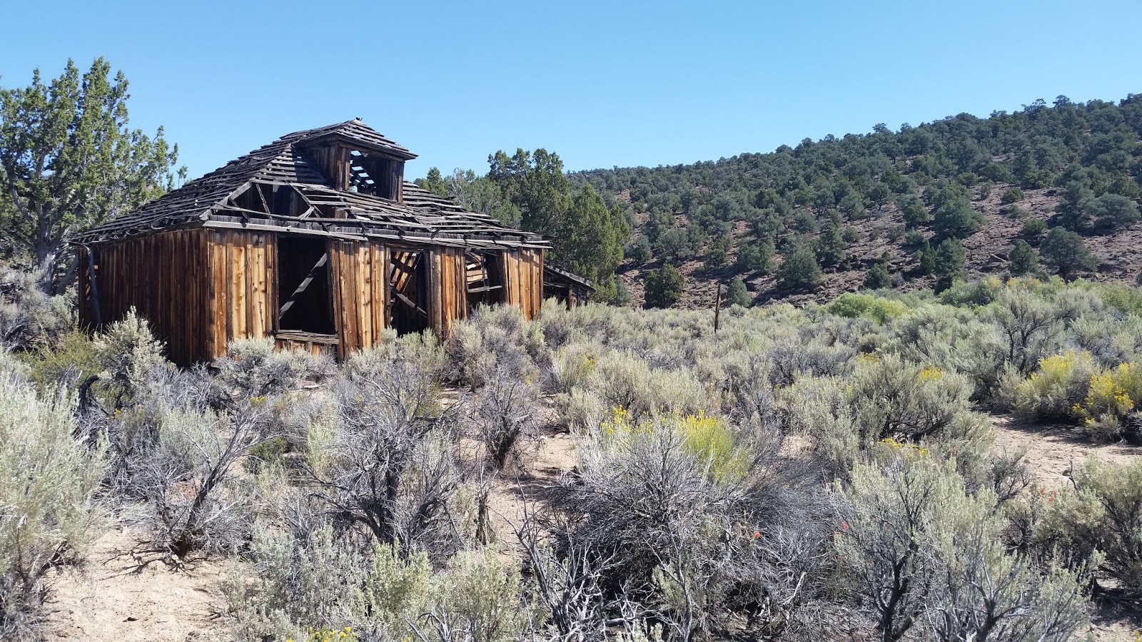
    Upper cabin in Georges Canyon

    Rock ring on Georges Canyon Rim

     Georges Canyon Rim

    Weird formations on the White Rock Peak route


    McCann Gorge
    The Mckinney Mtns is a subrange of the Monitor Range. Only Tonopah has gas and stores. An east side road leaves US 6 at mp NY 30.7 but hasn't been graded in years. A better road starts at mp NY 35.8 and runs north about 18 miles to a 4-way at Kiln Canyon. A good road goes NW from there for 9 miles to the mouth of McCann Canyon. It's 20 miles on to the paved Belmont road using the road up McCann and over into Hunts Canyon then nearly 40 miles on pavement to Tonopah. These dirt roads are maintained but I wouldn't take a low slung vehicle in there. McCann Canyon is the prettiest area and the best camp is at N38 28434, W116 41924 el 6750. More are at the pass on the crest el 7900+. The east side gets a VZ signal from a peak above Warm Springs, the SW side gets a signal from Tonopah. Posted 2018.
    • KILN CANYON has of all things, kilns. From the 4-way, go east 3 and a half miles on a sandy road to the first two. Then the road goes south a mile and a half to three more that have a huge carpet of charcoal around them. Less than a fifth mile up the canyon are cabin ruins on the left bank. A half mile beyond there is a dry thicket in the creekbed where a water pipe has survived, but I couldn't get thru to check the spring shown on the topo. I didn't visit the kilns in the north fork. This area is a gorgeous pj forest with countless camp spots  and no cattle. ITALIAN SPRING has a turnoff a mile and a quarter north of Kiln Canyon. The road turns into an ATV trail about halfway to the spring. Some ruins are there with a trace of water. A pipe brings some water down to the flats.  Posted August, 2018.
    • McINTYRE PEAK el 8105 is what I call the peak rising out of Stone Cabin Valley. From the 4-way at Kiln Canyon, go north 5 miles then west on a brushy road heading toward the south saddle. Go a mile on the brushy road then walk west up a drainage to the south saddle el 7400. Then go up to a 6 foot wide rock ring on the summit at N38 27467, W116 32420. That took an hour, but I wanted a longer hike than that. So I stayed on the crest running north to a flat at 28443, 32713 el 7900 then on to a viewpoint at 28660, 32477 el 7950. I could see the north summit el 8000+, so I kept going toward it. Some minor crags are on the crest but it was easy to walk the flat ground along the west side. When that played out I weaved up thru the crags then it was easy again to the 8000 contour line at 29292, 32246. The crest drops off beyond there. I retraced back to another rock ring at 28552, 32292 el 7800. Obsidian flakes were around there. I kept going south into the canyon running east of the high summit and it led back to the start with not a hint of water. This is all easy pj forest in pristine condition. 5 hours and the only noticeable gain is the 1200 up to the summit. The main road goes on north for 13 miles to Little Fish Lake, but it was dry.  Posted August, 2018.
    • LONGSTREET PEAK el 9240+ is what I call the peak at the head of Windy Canyon. A loop can be done from the canyon. From the 4-way at the mouth of McCann Canyon, go south on the main road for 5.7 miles to FR 405 at N38 22715, W116 39199. Go west on easy 4wd for 3 and a half miles to a shady camp at the Longstreet Mine. A few feet past there is a fading road forking right at 22826, 42711 el 7100. I walked to the end in a third mile and dropped into the next canyon to the north. I went on to a warm spring gushing out of the creekbed at 23490, 43533 el 7550. That's the best spring I saw in these mountains. I then walked up the right bank to 23601, 43779 el 7850 and followed along  the left side of a creekbed and then curved to the right into the main saddle west of Pinon Peak reading 23835, 43895 el 8450. The ridge from there leads up to the summit at 23531, 44328 with no sign of humanity. I walked south from there to 23445, 44514 el 9200 to get down to a major saddle then climbed back up to peak 9192 to stay on the high rim. I could see a mine trail on the south rim that leads back down to the start, but rain caused me to drop down the south side of a canyon at 22637, 44461 el 8900. I stayed high with easy going on the canyon wall and finally hit bottom at 22870, 43795 el 7750. A tent there meant pot farm, but it was recently abandoned. I kept going down canyon on game trails to a gorge then went right thru a saddle at 22955, 43203 el 7500 then down to the road and shortly back to the start. 5 hours with about 2500 gain. Long pants are needed for weaving thru light brush here and there. The mine road goes from the camp area on up the south slope of the canyon to a shady camp area el 7800 and then a foot trail goes on up to the rim next to point 8177. Jeeps could still easily make it and there are plenty of turnarounds. Posted 2018.
    • LONGSTREET CANYON has an overgrowing road to the Longstreet Ranch el 7100. Jack Longstreet lived there and worked the mine in Windy Canyon. From the 4-way at the mouth of McCann Canyon, go south on the main road for 3 and a half miles to N38 24583, W116 39545. Go west 3 miles to the ranch. 4wds can make it halfway, then it's an ATV trail but mtn bikeable. The trail goes on past the ranch for half a mile to springs, but cattle got there first. Apple trees at the ranch were loaded. Posted 2018.
    • BARLEY BENCHMARK el 9520 is as far north as I went on this trip. From the 4-way at the mouth of McCann Canyon, go NE on the main road for 10 miles to the Daugherty Ranch site. Go left there on FR 44093 for a bit over 5 miles to a pass el 8400. The last mile is easy 4wd. It's easy walking on the crest and soon the trees thin out and the route ahead is obvious to the main saddle at N38 36917, W116 39412 el 8550. I could look up and see a clear route thru the mahogany to a stand of the big trees. I went thru the stand then curved left to 36789, 39053 el 9400 and leveled off to skirt peak 9482 and then merged onto the crest. A quarter mile before the BM there is a convenient pathway left of center. The BM is at 37079, 38728. That took me 3 and a half hours with 1000 of noticeable gain. Light brush was not a factor with long pants. This peak is in pristine condition. Peak 9120 south of the pass looked easy. There was a small stream near the ranch and then springs along the road at el 7400 had a tiny flow. Posted August 31, 2018.
    • McCANN GORGE is what I call a scenic fork of McCann Canyon. It's easy to circle it on the bedrock rims. Park on the McCann road and start hiking up the canyon containing Bernice Spring reading N38 28434, W116 42103 el 6800. Go about 2/3 air mile then pick a spot to climb the left slope. I went up a gully next to a fence. Walk to the rim at 27901, 42470 el 7150. Then go up along the rim for a mile and cross over to 27176, 43073 el 7600. Next, angle up to a good view on the ridgetop at 27148, 42744 el 7750. Then just walk down the ridge to a mine road at the bottom reading 27880, 41938. The road goes to the main road then it's nearly a mile back to the start. That took me 3 hours, 20 minutes with 1000 net gain plus some minor dips, but never steep. The first half mile has some light brush then it's easy pj and bedrock. This is the most enjoyable hike on this page. There's a good camp spot on the McCann road near the start of this hike. Posted 2018.
    • WHITE ROCK PEAK el 9248 is what I call the peak at the head of White Rock Canyon. A loop can be done. Turn off the McCann Canyon road at N38 29519, W116 44472 el 7350 and go north on easy 4wd for .8 mile to el 7600 in an area of spectacular rock formations. Hike west up a drainage at 30194, 44624 el 7600 and it will top out at el 7800. Keep going to a 4wd road at 30298, 45088 el 7900 and walk up that to a saddle el 8287. Then go up the ridge thru an easy pj forest and it will level off at el 8800 where the rest is in view. Mahogany is the only obstacle. When I got to it, I stayed on the right edge of the crest and then moved into a clearing at 30877, 44186 el 8800 then on to 30850, 44062 to get to the next clearing. I weaved on thru to a neck at 30836, 43924 el 8800 and then dropped low on the right side. I found out it was safe to come back on top at 30786, 43683 el 8900 and then I kept going east up the center of the ridge and soon had a view. I went on to a passage at 30918, 43407 el 9000 then to 30945, 43338 where I started weaving to the right and soon the summit was in view and easy routes to it. Survey junk is on top at 31012, 43071. From there, it was easy to walk the south ridge then skirt west of peak 9183 and on down to 30390, 43849 el 8850 where easy slopes lead back down to the start. 4 hours, 1700 gain, not steep. Long pants are needed in the mahogany but there was always a passage. An alternate route would be from the road in White Rock Canyon, but it wouldn't be as interesting. Posted 2018. 
    • ROUND SPRING PEAK el 8844 is what I call the one on the crest south of where the main road climbs out of McCann Canyon. Turn off the main road at N38 28959, W116 45696 el 7850 and follow a DIY road for .7 mile up a canyon to the end el 8000. Hike on up the canyon and start up a low  ridge at 27982, 45182 el 8200. Go on to 27527, 45112 el 8400 where the rest is in view. Drop down and cross a creekbed at 27416, 45102 el 8200 and  go up the NE ridge to the summit at 27063, 45566.  That took me 2 hours, 37 minutes with 1200+ gain, 200 of it on the return. Some light brush. This peak is in pristine condition. The only good camping is along the main road at the divide el 7950. Posted 2018.
    • HUNTS CANYON has a dead end road going up it. It departs from the main road at N38 29386, W116 49661 el 6800. It goes upstream for a bit over 4 miles to the Hunts Canyon Cabin el 7100, a well kept public cabin. The road fades in a bog about a fifth mile beyond the cabin. That makes a decent mtn bike ride. Posted 2018.
    • GEORGE BENCHMARK el 9319 is a twin summit considered to be the high point of the McKinney Mtns. A 4wd road goes to el 8300 on the north side. Turn off the Hunts Canyon road onto FR 44707 at N38 29816, W116 54873. Go a fifth mile then turn left on FR 44127 and stay on the main road for 10 miles to a 4-way el 8450. Turn left on the road going downhill for a bit over 3 miles to a fork at 23230, 49530 el 7800 near Mud Spring where I saw the first stream. Go left there for nearly a mile to a divide el 8250. It's easy 4wd that far, but the next quarter mile down from the divide is harder.  It would be a 4 hour hike from the divide, but jeeps could still make it down into upper Hunts Canyon then it's a mile and a half on a better road to a fork at Flask Canyon. Turn up that canyon and drive nearly to the north ridge where the road gets bad. Hike up the north ridge at 22317, 46920 el 8400. It's easier to walk up the road to the drainage behind the ridge then switch back. It's a 45 minute hike up the easy, bald ridge to the north reg at 21850, 47000. Placed by M&L in 2000, it says it's the high point. It's an easy half mile south to the BM where a reg was placed in 2015 by Carey and Adrian. It says it's the high point. They came up Kellys Mine Canyon but had a 9+ hour hike because the trail is gone. A road goes west from Mud Spring back to the Belmont road but it's for OHVs and jeeps. Ranchers don't use it anymore. BIG TEN PEAK el 9115 can be done on the drive out along FR 44127.  I parked on FR 44127 at the SE canyon reading 23500, 51894 el 8200. I went up the left bank of the canyon for a fifth mile then got in the creekbed and went up to 23631, 52320 el 8550 where I turned left to get to the south saddle. The reg at 23885, 52540 was placed by M&L in 1993. It says it's the high point. That took 90 minutes with 900 gain and some light brush. On the one day, I climbed 3 different highest peaks in the McKinney Mtns. CHIMNEY PEAK el 8910 is what I call another major peak along FR 44127. Turn off at 27420, 52712 and follow FR 44127A until trees close in. OHVs can make it 2 miles to the end el 7950, 4wds make it half way or more. Aim for a minor saddle on the west ridge at 26578, 50887 el 8350 then the summit is at 26682, 50605. That took 63 minutes with 1000 gain. Nice pj forest, no brush.  The roads for these peaks are rarely rocky but ruts are forming on steep parts. The south fork of Flask Canyon has an aspen grove with some huge trees. Hunts Canyon had a good stream, all cattle were in lower Hunts on September 11, 2018.
    • HAT PEAK el 8644 is an easy one. Turn off the Hunts Canyon road onto FR 44707 at N38 29816, W116 54873. In fifth mile is the first fork. Stay right for 4 and a quarter miles then go right for a third mile to a short spur road on the right. Park there and get on the low ridge at 26149, 53479 el 7350. There is a faint track here that can be followed toward the south saddle. When the track goes left, get off and go up to the saddle then go north to the reg. 2 hours, 1400 gain. I did this years ago.
    • THUNDER MOUNTAIN el 7084 is a minor peak close to Tonopah. Turn off highway 376 at mp NY 7.9 and drive a mile to a free campground at Rye Patch pumping station. Get on an easy 4wd at the NE corner of the parking lot and follow that 3 miles or so to the north ridge. Hike up at N38 11409, W117 01373 el 6100 and walk the easy ridge to the Pump benchmark at 10280, 01639. A reg there was soaked. 2 hours, 1000 gain. RVs can park next to the campground. Posted 2018.
    • HANNAPAH PEAK el 6866 is south of US 6 and is named on Delorme maps. Turn off US 6 at mp NY 19.6 and go a fifth mile to a shady camp at McKinney Tanks. Keep going a little more past ruins then take a right fork and drive nearly 2 miles to the end el 6350. It's a half mile and 500 feet up to the summit at N38 04393, W116 53845. High caves are a quarter mile east of the tanks. There has been activity at the ones below the rim. On top are some rock alignments. All roads easy 4wd. Mtn bikes would work. Posted 2018.
    • RED PEAK el 7819 is north of US 6. It's a big pile of steep scree but there's a wuss route around back. Turn off at mp NY 20.1 and go 3 miles toward the peak. Only one road is still used on the south slope and it ends at N38 08924, W116 53959 el 6900. Walk to the upper road el 7000 then go left around the peak on game trails. Stay near that level under the scree to get at a saddle reading 09409, 53445 el 7300. Then go on to the next saddle el 7400 on the NE ridge and go up that to the reg. Then descend to 09217, 53465 and go on down the south ridge on soft scree. 80 minutes, 1000 gain. All roads easy 4wd. Mtn bikes would work most of the way in. Posted 2018.
    • WOODCHOPPER CANYON RIM - a loop hike can be done on this scenic rim in a gorgeous pj forest. Turn off US 6 at mp NY 24.1 and go 4 miles on 4wd then park at a washout. Stroll on up the road for 3 or 4 miles and then climb up to a break in the rim at N38 13078, W116 53120 el 7450. It leads shortly to a saddle el 7500 where a cave contained a log and a smaller piece of burnt wood. Far left of the cave is an easy class 3 route up over a minor cliff then stroll on to a view at 12636, 52877 el 7800 then go on to another view at 12384, 52614 el 7700. Next is a saddle at 12107, 52527 el 7550 then just follow the rim and drop down a shelf at 11756, 52197 el 7500. I descended off the rim down a drainage at 11250, 51700 el 7300 but could have kept going to peak 7638. That took 4 hours with 700 noticeable gain to get on the rim then some minor ups and downs along the rim. The road walk is boring but it's worth it for the payoff. This is the most enjoyable hike in the southern part of the  range. Horses haven't been on it. SAULSBURY RIM is an easier loop hike nearby. Take US 6 to the Saulsbury rest area at mp NY 25.4 then go north on a decent road along Saulsbury Wash. After a bit over 10 miles is a 4-way at Warm Spring which had pools that weren't warm. Go left there on road #164 which had just been graded. After about 2 miles start hiking up an easy ridge el 6800 and top out on the rim near point 7193.  Shortly there is a large rock ring at 15699, 52124 el 7100. Keep going on the rim in a thin pj forest to 15015, 51514 el 7050 then on to 14319, 51905 el 7000 where you drop into a canyon that had a good stream but likely seasonal. Stroll on down canyon then exit up an easy drainage to get on the rim at 14322, 50817 el 6800. Walk the rim to the end where it tapers down then head back to the start. This takes 3 or 4 hours with hardly any strenous gain, but there's horse shit nearly every step of the way. The stream wasn't polluted nor was the rock ring disturbed. RVs can part at the rest area overnight.  Posted 2019.
    • YELLOW CONE el 7135 is just south of US 6. Turn off at mp NY 29.1 and drive a mile and a half to where the main road tops out next to towers. Turn toward the peak on a faint unmapped road that ends in a fifth mile el 6600. It's less than a mile to the summit. I angled up to the left to W38 06686, W116 45279 el 6900  on the SE ridge then stayed left around talus to survey junk on top. No backsliding. All roads easy 4wd and mtn bikes would work. WHITE HILL el 6810 is what I call an interesting formation nearby. Retrace back to the road on the flats and go south on it for 1.2 miles to a main fork and go right on easy 4wd. It's nearly 3 more miles to a large mine area and it's a 15 minute hike to the top of the hill at 05262, 45755. Posted 2018, 2019.
    • GEORGES CANYON has a perennial stream. I saw fish 3 or 4 inches long. Loops can be done in a vast pj forest using Georges Canyon Rim. Take the east side road to FR 44164 at N38 13032, W116 41257, next to Fourmile Spring. Go NW a mile and a half then go right on FR 44164B. Go a mile and a quarter on that to a fork and go right for about 6 miles to Fancher Cabin. Go right for half a mile to the end of the road el 6750 with shady camping. OHVs can make it another fifth mile. The roads are easy 4wd and rarely rocky except for a quarter mile on 44164B chewed up by floods, and that might get fixed. It gets brushy near the cabin. I walked up the washed out road to another cabin then crossed the stream at 19927, 43597 el 6950. I walked the bank above the brush and on to a minor drainage at 20201, 43479 el 7200. I crossed that then went up a slope at 20313, 43247 el 7300. That levels off at el 7550 then I stayed on the high ground to 20842, 42657 el 7750 then stumbled onto a rock ring at 21036, 42638 el 7750. If that's Indian, you gotta wonder how many more there are that I could hit one on my first try. I kept going to the rim at 22063, 42600 el 8100 with a good view into Windy Canyon where I could see the next day's hike. Now I turned down the rim which soon got very easy and had some old cairns. I strolled down to a drainage running south at 20302, 42382 el 7550 and went down that to 19821, 42787 el 7450 and stayed on the high ground to 19482, 43068 el 7250 then down that ridge to the start. 5 hours with 1100 net gain, and some minor ups and downs. But only about 300 of the gain isn't super easy. Endless loop variations are possible because brush isn't a factor. It's borderline for long pants because I was rubbing against bushes and small branches here and there. ALTERNATE : Two days later I found a partial trail running up toward the rim. I got on it at a main fork in the canyon. Use the same stream crossing as above at  19927, 43597 el 6950 and stay on the high east bank a short way to the main fork.  I was on a cow trail in the left fork and it started climbing up to the bench between the forks in the area of 20430, 43577 el 7150.  Soon I saw cut limbs and knew it was man made. I lost it but hit it again at  21071, 43327 el 7400. It faded again but was heading for a saddle at 21388, 43068 el 7700. It was easy to go on from there without a trail to the trail coming up from the Longstreet Mine at 21981, 42970 el 8050. I went right on that for a tenth mile to  the rim next to point 8177. Then it would be the same hike back as described above. Posted 2018.

    Thursday, August 23, 2018

    Pahsimeroi Mountains


    McGowan Benchmark on the left. Somewhere to the right is an 11000 foot peak where a climber named Darcy fell and died in 2012. I skipped that one.

    Dickey Peak
    Christian Gulch South Fork

    Christian Lake
     This range is a subrange of the Lost River Range. It's drier and that makes for less brush and it's not surrounded by farms. US 93 runs along the west side then to Ellis where Custer Rd goes south along the east side.  Doublespring Rd leaves US 93 at mp 131.2 and cuts over to the east side to form the northern boundary. That road is maintained but bumpy and has the best camps north of the pass. Christian Gulch  has shady camps too. Challis is the main supply point with a supermarket and Family Dollar. Ellis has nothing. Posted 2018.
    • DICKEY PEAK el 11141 is the high point of the Pahsimeroi Mountains. An easy 4wd road goes to el 7850 on the NW ridge. Take US 93 to mp 135.9 and turn at the sign for Arentson Gulch. Go east nearly half a mile then go north on the main road for 2 miles along a fence to a 4-way reading N44 13994, W113 55847 el 7150. Mtn bikes are practical that far. Go right at the 4-way for nearly a mile to an aqueduct where the road tops out on the NW ridge reading 14337, 54973 el 7850. Some shade and a small camp spot are there. Go up the easy ridge to treeline el 9200 then scree sets in. I zigzagged up on goat trails with hardly any backsliding. The summit is at 13758, 53011. On the descent I could see the mega spring el 8600 that feeds the aqueduct. Not one to pass up an ice cold spring, I followed a goat trail down the gully that leads to it. Then I went down the stream 600 feet to a huge dead tree on the right bank. I was reading 14191, 54061 el 8550. At that point I climbed out on the left using elk trails to get back on the ridge then it was less than a mile back to the start. That took me 4 hours, 9 minutes with 3300 gain plus a little to get up from the spring. Skipping the spring would bring the hike well under 4 hours. I thought it would be a longer hike than that. The ascent ridge has what looks like earthquake damage near the start. Now it's an ATV blocker. Posted, August 2018.
    • PETROS PEAK el 11040 is what hikers call the next 11000 footer north of Dickey Peak. A steep route goes up the west side, but there's an old coot route up the Christian Gulch South Fork. Take the Doublespring Rd for 14.5 miles NE from US 93 to the turnoff for the Gulch. It's about half a mile outside the forest boundary reading N44 18722, W113 47840. Go 2 miles up that high clearance road then go left on FR 272 for a mile and a half to a meadow at the end reading 17841, 51348 el 7700. There is shady camping there. Go up canyon for 700 feet on an elk trail then it goes on the right bank a short way then comes back down. At 17213, 51766 el 8000 it goes up the right bank again. I had no trouble following it, but here's the waypoint sequence just in case. It crosses to the left bank at 17030, 51961 then climbs up 100 feet or so above the creekbed. It goes on to 16738, 52362 then 16633, 52538. It gets spotty after that but not needed. It's easy to walk the drainage to a grassy bowl at 16030, 53732 el 9495 where springs gush earlier in the season. Just keep following the smooth ground along the drainage up to the summit at 16879, 54477. 6 hours, 3400 gain. This is the most enjoyable hike I did in the Lost River Range. No brush, no bugs, no loose scree and what little is steep can be zigzagged. Snow near the summit was the only water I had, but there will be an intermittent stream if your timing is right. Posted August 11, 2018.
    • CHRISTIAN LAKE el 9500 is what I call the one in the north fork of Christian Gulch and it's easy. Drive the same as Petros Peak, but don't turn on FR 272. Stay in the main canyon another 1.7 miles and go right on 4wd or keep going another half mile and go right on FR 426 which might be 2wd.  Both roads converge at a meadow where the canyon forks reading N44 19083, W113 52882 el 8000. The left fork has the lake, but it's better to walk up the right fork. Stay on elk trails along the creekbed. There was still a stream for the first half mile. Exit up to the left at 19505, 53458 el 8400 and go up to 19762, 55456 el 8700. Now you're on the north rim of the left fork so just stroll on up to the lake at 19722, 55397. I could look up to the 11000 footer north of the lake and saw no obstacles on the ridge to it. For a loop back, retrace the rim and drop to a spring at 19531, 53905 el 8700 on the  floor of the left fork. I didn't filter that. Then walk to an elk trail at 19490, 53679 el 8550 that goes down that fork. The trail fades on the flat bottom then stay left of the creekbed to walk down the little ridge between the forks that drops to the meadow at the start. That took me 3 hours, 15 minutes with 1500 gain, hardly any steep. This is one to do in July when the lake is bigger.  Posted August 12, 2017.
    • MCGOWAN PEAK el 10700+ is fairly easy because trails go up McGowan Creek. Take US 93 to mp 147.1 and turn on a high clearance road that goes 2.3 miles to the mouth el 7000. It's mtn bikeable. An old constructed trail goes left around a thicket at the mouth and follows along a scree slope then comes back down to the creekbed in a fifth mile. It goes up canyon for .75 air mile as measured from the TH where a small stream was flowing. A tenth mile beyond that it enters a meadow and then it's elk trails along the meadow to a spring on the right bank at N44  21039, W113 59362 el 7750. I stayed on the right bank on elk trails to the first main fork el 8100. I went up the right fork to an elk trail at 21436, 59315 el 8150. I decided to use that trail to go up onto the south rim of that fork and it was an easy forest up to 21116, 58828 el 9150 where the rim gets steep and rough. At that spot, I used a game trail going up to the left to get back in the drainage and then it was obvious up that to the west ridge at 20922, 58554 el 9950. The ridge is class 2 and the McGowan benchmark is at 20934, 58204. A good view into the endless Grouse Creek can be had by walking to a point 450 feet east of the BM. I retraced to el 8400 then took a shortcut down a ridge at 21350, 59299 el 8250. 6 hours, 3700 gain. No loose scree. Long pants are advised because some patches of tall grass and other soft plants are in the main canyon as far as the spring el 7750. Shorts work beyond there. Doing this before August might mean dealing with boggy meadows. The stream was only running for half a mile. Posted August 14, 2018.
    • PEAK 10620 is an easy one at the north end of the mountains. A 4wd road goes to el 8900 on the north ridge. Take US 93 to mp 152.1 and turn at the sign for Lime Creek. Go 7 miles on easy 4wd to the chicken TH el 8000 where there is shady camping. Walk a tenth mile up the road to the worst spot at N44 24069, W113 59456 el 8100 and decide if it's worth tackling that. It's just a speed bump for jeeps. I rode on past it for a mile to el 8900 on the crest then walked to an elk trail at 23877, 58844 el 9100 and followed that around the east side of point 9182 to the saddle el 9100 behind it. The trail goes up out of the saddle then bends right into the trees and fades. I just kept angling up thru the trees to the NW ridge then it was a simple walk along the crest to the summit at 22118, 58212. There is a minor dip a quarter mile before the summit that some rate as class 3, but it's more like class 2 to me. I saw no danger there. Some hikers go up the steep ridge from the chicken TH, but I would walk the road and use the ridge on the descent. Posted August, 2018.
    • GROUSE CREEK MOUNTAIN el 11085 has a 4wd road up the NE ridge to el 8350. Use the graded West Double Spring Rd on the east side and drive to N44 24386, W113 47593. Turn there on easy 4wd and stay on the main road to a grassy road on the left at 23701, 51269 el 7400. The grassy road appears to be open according to the online MVUM. The road goes up to a fork at 23156, 51547 el 8150. Stay right for a quarter mile to the end el 8350. Then just go up the ridge thru the trees to 22207, 53356 el 10250 where the rest is in view. The summit is at 21966, 54497. 4 and a half hours, 2700 gain. There's no brush but mosquitoes converged on me at el 10400 and nowhere else. Some biting flies are lower. I saw no water except for snow even in canyons below. Posted July, 2018.
    • MILL CREEK, on the north side of Grouse Creek Mtn, has a 4wd road. It's a good ride for cycles and mtn bikes. Turn off the main east side road at mp 19.8, across from Livestock Rd. Follow the road for 5 and a half miles to aspen with camps and a stream el 6450. OHVs go beyond there. No recent grazing. Posted 2018.
    • GROUSE PEAK el 8464, at the north end of the Lost River Range, has an easy 4wd road to lookout ruins on top. The road goes on down to Challis. Turn off the main east side road at mp 8.1 and go 2/3 mile and cross Lawson Creek . The correct road, #111, runs on the north bank and there is just one main road to follow 9 miles to the crest. Grouse Peak is half a mile north. A mile and a half south on the crest is where #111 drops down to Challis. This dirt road is nearly 20 miles long and good for dual sport cycles. No gates except the side road to the peak. Posted 2018.
    • LONE PINE PEAK el 9658 sits on the west side of US 93. A 4wd road goes to el 8600 out of Bradshaw Basin. Take US 93 to the sign for Spar Canyon Rd at mp 144.2. Go 7 miles on that good road to power lines then take the far right fork for .8 mile to another fork at N44 17335, W114 10267 el 7000. Go right on 4wd with some minor erosion and there's just one main road to follow to el 8600 where it shrinks to a rubbly ATV trail. Shady camps are off to the left. I walked the ATV trail for a fifth mile then cut left to 19487, 09686 el 8950 and walked faint game trails along the base of talus. I topped out at el 9200 then dropped to the only saddle at 20045, 09816 el 8950. For the summit ridge, I stayed left of a crag to 20596, 10165 el 9600 then walked north on a natural pathway for a tenth mile to the BM. That took me nearly 3 hours with 1500 gain, 250 of it is on the return. Nice forest. I could wear shorts in that thin sagebrush. Horses and cattle are here but they don't go above 8600. They don't have ATVs. Posted 2018.