
 |
| 1940s Pepsi bottle at Coon Hollow |

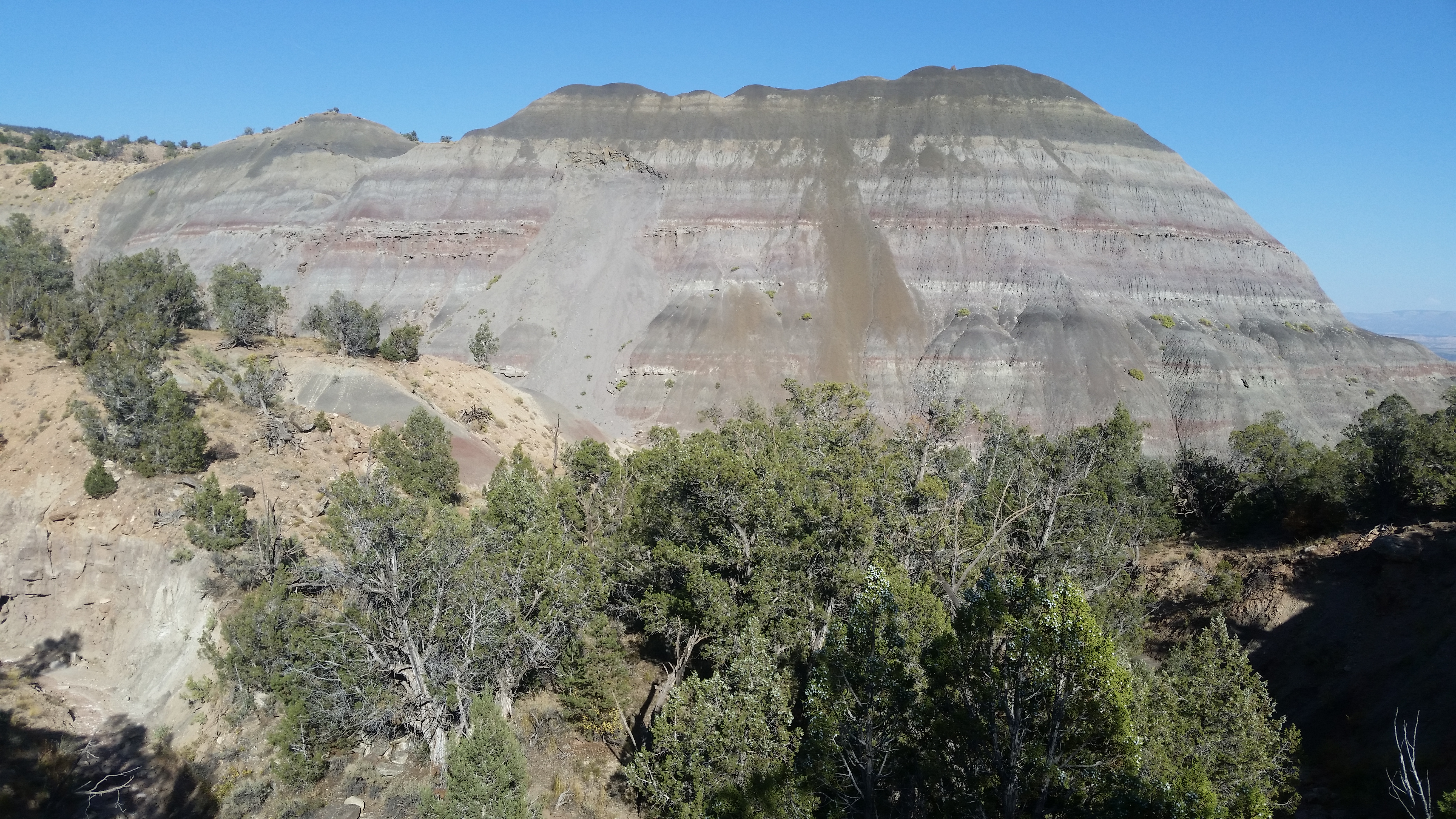
- PYRAMID ROCK el 5540 is fenced off with closed signs but I assume that's for vehicles. I made a loop from the south. I rode the west road then around to the south road to a left fork that is fenced near point 5009. I walked to a wash at N39 18063, W108 16010 and stayed straight to an obvious drainage ahead. It goes up left then bends right to the east ridge. I went up to the summit then came back and down to 18521, 15947 where a grassy slope leads down to the main east saddle. I only had one way to go to get on the east peak and had an easy ridge to 18602, 15250 where a spotty trail goes down the left side of a drainage. I then walked the main wash down to a fence and followed trails along that back. 2 hours, 18 minutes with 800 noticeable gain. Good badlands and I didn't disturb any of it on this loop. Posted 2023.
- COON HOLLOW is an interesting area west of De Beque. A good loop goes up the jeep road then back on the south rim. County V.2 goes in paved then gravel then easy 4wd to the parking spot south of peak 5464. A cow trail runs along the south base of that peak and meets a road that leads to the jeep road running up canyon. I walked it to el 6300 where it turns west. A faint road branches left to a defunct stock tank then it's easy on to the rim at a saddle el 6400 . I went over peak 6640+ then down the SE ridge but hit steep drops at a rim. So I should have gone down a gully at N39 18536, W108 20597 to the rim then right to a gully with a tunnel at 18442, 20694. The tunnel doesn't go thru so I went over it then down the drainage to a bridge and crossed on it then had easy shelves and then a dirt bike trail. I just stayed on the rim to peak 5945 then dropped off a rim at 18339, 17974 then down the final ridge at 18393, 18129. It's a 5 or 6 hour hike, 1500 noticeable gain, 11 miles. Easy terrain, good pj forests. I put a track on peakbagger under peak 5945. The jeep road up canyon is good for all two wheelers until where it climbs up and that gets tough even for jeeps. Posted 2023.
- UPPER COON HOLLOW has a lot of forks with good looking badlands. Short loops can be done. The road up canyon is easy 4wd to a washout at the 5560 line. A bypass goes left into the main wash but has sharp dips. Two wheelers make it thru. I strolled up the canyon west of peak 5830 and came to a big fall el 5950. I went up the left slope there at N39 19698, W108 21263 then walked the ridge to 19864, 21677 and could see a gully down to my left leading into the next canyon west. I walked it down to the floor then downstream to a slide of dark dirt that nearly blocks the way. I should have got on the right bank there because I came to a big drop below the slide and had to climb out anyway. I went down a drainage at 19552, 21495 to get back in. Near bottom I could have stayed on an easy rim and hit bottom at 19557, 21366. I walked down to the road and back. 2 hours, 20 minutes with 400 noticeable gain. WASHOUT CANYON - the canyon at the washout el 5560 runs north into some good badlands. It's an easy stroll for nearly a mile to a fall blocking the main left fork . The right fork gets bouldery but might go thru. A longer hike is to walk the west rim then down a skinny rim to the west. The rim goes up easy to a good pj forest el 6700. I walked west thru that then should have tried the long ridge going south to 29 on the topo. It looked OK from below, but I went down the gully on the west side of it and had a tricky little drop. Once down it's easy to move right to the skinny ridge and walk it down nearly to the saddle west of peak 5830. It gets too skinny along the way and I had to drop left then come back to center at el 5880. 2 and a half hours, 1200 easy gain. The skinny ridge is the best in the Coon Hollow drainage. Posted 2023.
- PEAK 6855 - I did a loop over that in upper Coon Hollow to the jeep road then down the south ridge. I rode up canyon to where the road climbs up and parked el 5700. 4wds would have to park a mile sooner. Then I walked the main canyon west past peak 6030 and the canyon narrowed down with mudslides trying to block the way but it's not hard to get thru yet. At a fork reading N39 19069, W108 22699 el 6250 I went right for 200 feet then up the right bank. I had clean slopes up to 19354, 22818 el 6900 where I leveled off toward the jeep road. I dropped too low along there and should have gone up to 19551, 22785 near the road. The road is nearly gone. It crosses a tiny stream where a bear lives. I walked it then veered south over peak 6855 and to the south ridge at 19491, 22098 el 6750. I dropped to a class 3 break at 19470, 22133 then at 19401, 22104 I dropped off the left side of the ridge then came back to center then down to el 6400. I then dropped left to a drainage at 19269, 21950 and crossed to the far side and walked the rim down. 4 hours, 15 minutes, 1000 noticeable gain, some easy class 3. I found a 1940s Pepsi bottle near the start half buried. An ebike is the best vehicle for the road up Coon. Posted Sept, 2023.
- MOUNT LOW el 5801 is a lonely one but good loops are possible. I started up a scenic wash along the Coon Hollow road at N39 18875, W108 17302 and strolled up nearly a mile to a main fork el 5150. Taking the right fork would make a good short hike, but I went left to get on the ridge between the forks. I followed the ridge up over point 6058 and on up to the main ridge east of peak 6520. I then rim walked down and left of peak 6268 then down a ridge at 20547, 17263 and on to a wash at 20543, 16818. I walked that to a drop and went down the left side to a rim and walked it to a huge shelf el 5650 and followed that to the peak. Routes go up the south side of the summit block. Just survey junk was there. I retraced back to a faint ATV track and walked it down a clearing and it might go where I needed to go but I took a direct line to 19917, 15551 where I could go down a slope to a wash which I followed south to the main road. 5 hours, 20 minutes, 1400 noticeable gain. An ebike works for the 2 mile shuttle. An easier version would be to start on the new road to Twin Peaks and walk one way down. Posted 2023.
- SULPHUR GULCH has one way options using the north rim road. I was camped at point 5370 and rode my Zizzo down the rim for 3 and a half miles to a road at point 4971 cutting over to the rim. A game trail there at N39 16445, W108 15714 leads down. I soon hit a tiny stream which I saw on the sat image but thought it was an early season stream. I barely stayed dry strolling up to a main fork el 5040 and took the right fork. It had a stream but soon ended and I walked under camp then to a fork and stayed left then came to boulders. I might have passed those on the west rim but I weaved thru then stayed right in a fork and easy ground to the WF road then back. 2 hours, 18 minutes, easy hike. Next time I'll wear wading shoes. No sign of cattle ever. I went to retrieve my bike and returned on the much better road running up to the south side of Pyramid Rock. Posted Sept, 2023.
- HORSESHOE CANYON is an easy one but not as good as Sulphur Gulch. I parked on the north rim NE of point 5725 then rode my Zizzo down to point 5413 and dropped in at N39 16012, W108 17502. I went down to the last cliff above a flat then left to a slide to get down. Then I walked the flat to the mouth of White Sage and down. I strolled up to the exit at 16508, 20761. 2 and a half hours for the hike, 100 noticeable gain. I wouldn't do this again but I might come down from the WF road and exit at point 5725. That looks to be unburned. Posted 2023.
- 6 CANYON is what I call the one draining into Sulphur Gulch near peak 5865. It would be easy walk to the mouth and admire the formations but the canyon is blocked high up. I made a good loop up a ridge to the east then down the west rim. I parked at mp 9 where there is a sharp curve near peak 5540. I walked the wash there and stayed right at the first fork and on into a fork at N39 17585, W108 20904. I went on up it another 400 feet then up a ridge on the right and all the way to a plateau at el 6350. I turned west to a gully at 17932, 21642 el 6200. I went up that then leveled of along the south side of peak 6440+ and had it easy to a canyon. I went up the far side at 17910, 22047 el 6150 then on to the rim of 6 Canyon at 17930, 22292 el 9300. I dropped down there and followed a streambed into the canyon but it goes into a sinkhole. So I went left down a gully at 17937, 22417 and up to the west rim then down. Near the bottom is a wide gully on the right that leads down to washes and those lead to Sulphur Gulch which leads to the road. Nearly 4 hours and about 1000 gain, rarely steep. Really good color and bizarre erosion. Over a mile could be saved by spotting a bike at point 5799 but Sulphur is a nice wash walk. Posted 2023.
- PEAK 6642 - I made a loop up the south ridge then down an east ridge. Leave a bike on the WF road at mp 12.1 where a faint road goes to a stock tank. Then drive on west 1.3 miles to point 6025 then hike up the south ridge and over the peak to a bright gully on the north side that leads into the canyon running east of the peak. At N39 18364, W108 23896 el 6500 start climbing out at an easy angle to the east rim at 18378, 23795 el 6600. Drop down the other side then stay along the 5960 line on open ground to the ridge with the number 1 on the topo. Go SE down that main ridge to 17687, 23105 el 6200 then drop down the right rim of a gully. When it turns to badlands soil, move to center on easy rocks and when those end move back to the right at a tree then down. At bottom a good side trip is the next canyon downstream with good color. Then head for the stock tank road on the topo and out. 4 hours, 1200 gain, all easy. 3 hours if skipping the canyon. Good pj forest, mostly j. Posted 2023.
- 6025 CANYON is a good short one at mp 13.4 on the WF road. At point 6025 a road goes north and then bends left in a quarter mile. I got off there and went right into the canyon and up to N39 18444, W108 24472. I went up the left slope there to 18422, 24499 and leveled off and soon merged onto the rim and strolled down thru a good juniper forest. I aimed for a ridge at 18015, 24626 that goes down easiest to the mouth. Under 2 hours, 200 noticeable gain. Posted 2023.
- ALKALI CANYON is the longest badlands canyon along the Winter Flats road. I made a loop in the major forks. I parked near mp 17 and walked up canyon to the fork just south of the 6 on the topo. The 6 fork is best but blocked just south of the 6. So I took the east fork to N39 18222, W108 28655 where I could cut back over a saddle into the 6 fork. But first I checked out the east fork to the end and it's good but might skip it next time. I then went up the 6 fork and came back to a point at 18121, 28718 and climbed out and on SW to 18078, 28947 where I could drop into the next fork. I hit a shelf at el 6400 and walked it upstream and merged into the main creekbed then left that at 18084, 29225 and west over the rim toward a basin in the west fork with two tiny 6600 circles. I dropped into the west fork at 17868, 29509 and any further downstream would not work but upstream would. I strolled up the fork to the basin where a fence was the only eyesore I had all day. I got behind it for some good badlands pics. I then walked the south bank to 17692, 29494 and dropped south into a drainage with ponderosa pines. In a few feet I moved right past a boulder to get to the main creekbed then down it to the mouth where brush was in the way but I used a trail on the left bank to hit the creekbed of Pine Gulch. Shortly down that is an unmapped road at 17401, 29659 el 6400 on the right bank. With a bike there I would have had a smooth ride back but I didn't study the sat image. The road pulls away from the creekbed and then I left it and shortcutted down the creekbed and hit the road again and back to the start. By skipping the east fork and using a bike for the last 3 miles this would be a 5 hour hike with 500 noticeable gain. I made it OK in shorts but could have easily guessed wrong and needed long pants. Cattle don't go into the upper forks but bears do. If just doing the 6 fork or east fork I would try coming in from stock tanks to the east and aim for the east fork at 18125, 28573. That would be easy. Posted 2023.
- KNIGHT BENCHMARK el 6701 is on the east rim of Main Canyon. It's a short hike but I made a day of it by riding rim roads. At 11.1 on the WF road is an easy 4wd road going south to 3 forks at N39 14023, W108 21274. Left goes out to rims and far right goes to the rim of Pine Ridge where a cliff is in the way. There is stairway on the right at 14138, 22257 that goes to the top then to the left is a road. It looked like a road was constructed to the top but no one noticed the cliff. I just walked the road to the rim then on to the summit. It's a nearly 3 hour easy hike. I rode back to the 3 forks and headed for the rims. The north rim of Asbury Creek is easy 4wd to point 5855 above I-70. The rim of Main Canyon is for OHVs and I went as far as an overlook above Cameo near point 6288. Everything but the Main Canyon rim is firm and ebikeable. Some fat tire ebikes might work on the Main Canyon rim. No rocks. I put a track for all this on peakbagger. Posted 2023.
- ASBURY CREEK is by far the best canyon along the river. A trail goes in from the south rim along the canyon on the east side of peak 6044 but it takes an OHV to get at it. The sat image shows the OHV trail dropping in and it ends on a slickrock shelf. Then the foot trail goes along the right side of the canyon at that level and soon gets fuzzy. I went too low but found out on the return that the trail resumes at N39 11196, W108 19192 and bends right to a white cabin in view on the sat image. I went down along the east side of peak 6044 and hit bottom then had an easy stroll up canyon past point 5485 to an arch at 11909, 20347. I made a U-turn down canyon to a trail on the right bank at 11292, 18503 el 5200 that goes up then down to a trail on the right side of a gully at 11136, 18271 that leads down to a spring. It pours over a fall there el 5000 that ends travel. I then retraced back and was able to find the trail out. Next time I would stay on the trail to the cabin and try to go direct to the spring then go up canyon to the arch. I saw no way up to the north rim. I spent 5 hours but got lost. A Verizon signal on the rim makes it easy to navigate the OHV trail. It's easy 4wd to a fork east of peak 6004 then a fat tire ebike might work for the last 5 miles on the OHV trail. The GPS track I put on peakbagger for Knight BM shows the roads. Posted Oct, 2023.
- UPPER MAIN CANYON - a one way hike can be done from the road crossing el 5950 downstream to the Round Mountain Trail that shows on newer maps. I rode the WF road to mp 19 and turned left down to the crossing. I left my pack there then rode on 8 miles and parked where the road drops to a gas well. I then rode my Zizzo bike back to my pack and dropped in on the north bank where the road pulls away to avoid brush. A tiny intermittent stream was there and I had an easy stroll down to the RMT. The last mile is best because horses can't get in. I got on the right bank at N39 12924, W108 23262 then walked a trail downstream for a tenth mile and hit the RMT. That goes up and bends left at 13146, 23454 and then at el 6200 it goes right somewhere but I just kept going up to the road at 13627, 23794 el 6350 and walked it back to the start. This is a bit over 4 hours and 1000 gain for someone with a 4wd and ebike. I took 5 hours as I walked the road some. This is the best part of the canyon but I would take wading shoes in May. All roads easy 4wd. There is free campground on Round Mtn just west of peak 6820. Posted Sept, 2023.
- HUNTER CANYON SOUTH FORK is best done as a one way with minor rappells up to 50 feet. The trail up out of Adobe Creek would be one way to get in. I made a hiking loop from the top down. I parked along the road (a good camp is near there) west of Corcoran Peak and dropped down a ridge at N39 18593, W108 31842. I followed paths thru light brush then near bottom moved right and hit bottom at the 6360 line but I should have stayed left on a path that hits bottom at 18756, 31922. Either way works then it's a dry,open creekbed and at el 6200 there was a seep and plenty of water. At el 6000 I came to a 50 foot drop and I walked the north rim then down a little ridge at 18767, 33362 to get back down below the drop. But soon I had a 6 foot drop at el 5880 and decided to bail. I went straight up the south slope on a faint trail at 18743, 33422 and about halfway to cliffs I leveled on a safe trail for a tenth mile to 18722, 33524 then directly up on game trails. At 18660, 33491 el 6200 there is a trail bending left up to another trail at 18591, 33471 and leads up to a burn area. I stayed on the right edge of the burn until I saw a trail going up thru it then stayed on center in thin grass to a road at 17867, 33792. That road is on the topo and tops out at el 7450. If I had my folding bike stashed there I could have coasted the last 2 miles back. 4 hours, 17 minutes with 1500 gain. Next time I would reverse this now that I know it goes. An ebike for a shuttle would make it easier. Rappelling thru would start at the 50 footer with trees for anchors. The remaining drops would be less and I know there is a 20 footer near the mouth and it had a pool. Fresh bear tracks were in there, even below that 6 footer that turned me back. Take bear spray. He'll be pissed now that I've exposed his hideout. The best road in is graded county X.5 running north of Corcoran Peak then turn south on the road thru the west pass. That road is high clearance with ruts but no rocks. Posted Sept, 2023.
- TWIN PEAKS el 7442 has a new road on the north side to el 6800. The Roan Creek Road goes NW out out of De Beque to county X.5. Go 2.7 miles on that to a sign for Rustic Ranch then go left on a good road then stay on the main road. Some cars can make it to el 6250 then it's easy 4wd to N39 20666, W108 19854 el 6700. I could see a steep route up to the main ridge but didn't know I would be doing a traverse, so it's better to come down that route. So stay on the road then start up a ridge at 21020, 20641 el 6850 and up to a game trail at 20914, 20808 el 7200 that leads to the main ridge then up. Going down the main SE ridge has a couple of class 3 drops of 4 feet or so. That's narrow and to be avoided in howling wind. Short hike. The 6 miles of dirt road is ebikeable. Posted 2023.
- ALKALI CREEK is a top notch wild area 6 miles east of De Beque with super easy walking, north of Castle Peak. A good road goes up Horsethief Creek then bends north to Smith Gulch. I parked on BLM land at N39 19479, W108 07357 and could have drove a car all but the last quarter mile. It's all public road. I then followed the topo up a fork of Smith to get into Alkaline and went up to the first major fork just below el 6200. I took the east fork along the south side of Housetop Mtn and it had a stream and little falls then at el 6600 there is a 20 foot fall with a flow. I saw the resident bear has a trail up around the right side so I went on to a fork at el 6900 and then turned back to the main fork below 6200. I took the other one and it had a stream for a third mile. I stayed left at main forks to water running over bedrock at 17914, 04264 el 6650. Not far past there is a tricky fall then one past that and so I turned back to the fork at el 6400 and went south in that but it gets bouldery and not worth it. I put a track on peakbagger under Horse Mountain. That took 8 and a half hours and only maybe 200 feet gain that wasn't super easy. Just going to the falls in the east fork would be less than 12 miles round trip and that's the best fork. All forks have plush forests of large conifers. I stayed dry but might not in May. Hikers who like to thrash around in brush will need to pack their own because there isn't any. And bear spray might be good in case that's a dopey bear who doesn't know he's supposed to be afraid of humans. Or invite a friend that you can outrun. I saw a million bear tracks in dry mud but nothing recent. No sign of cattle ever. I put a track on peakgagger under Horse Mountain. Posted Sept, 2023.
- SMITH GULCH is a well preserved little jewel on the north side of I-70 east of De Beque. I rode in on the road shown on the sat image but on the ride out I saw the No Trespassing sign. So next time I would go on Memorial Day and park 2 miles west on BLM land at an underpass. Then I would ride my folding bike on old highway 6 to it and walk under the freeway and on up canyon. I saw no signs along there but it is private. If that fails, then the north side of the freeway could be walked to where BLM land nearly touches it then circle over to the canyon. It would be worth all that only if the stream is flowing and that can be checked at the highway. A little over 2 miles up canyon are little falls. The left bank passes those then merges back to the creek. I had to get on the left bank again but the right bank might be better to get at the source of the water. I spent 2 hours but it would be twice that if I had to walk from the underpass. No sign of cattle ever. Posted Sept, 2023.