 |
| The crest trail running toward Wilson Peak |

 |
| Humboldt Canyon |
 |
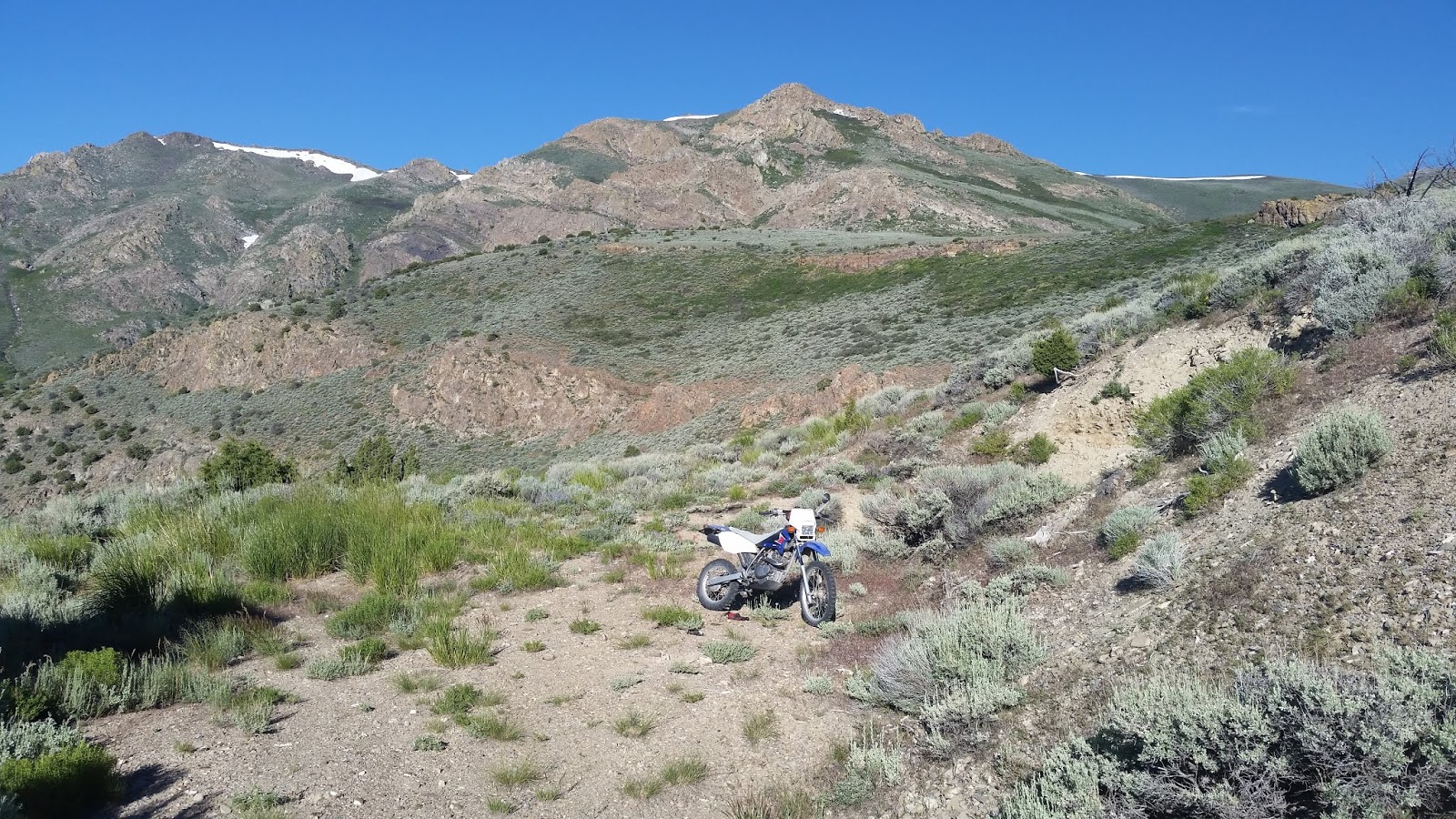
| Star Peak as seen from the south. The white line straight down from the summit is a spring gushing out of rock. |
 |
| Wright BM |
- INDIAN PEAK el 8931 has easy access from Spring Valley Pass. Take I-80 to exit 119 then go east for nearly 10 miles on a paved road to a graded road on the left. Go a tenth mile on that to the pass then turn NW on 4wd. It's easy for a mile and a half to the second gate el 6750, but maybe not worth it to drive beyond there. I went up the ridge staying close to center until N40 21057, W118 10572 el 7900 where I leveled off on the left side using a faint trail then merged back onto the ridgetop at a minor saddle el 8100. Then I went up to a spotty game trail at 21544, 10655 el 8450 that skirts around the left side of peak 8734 and into the only major saddle el 8450. The reg is a tiny pill bottle at 22204, 10931. 4 and a half hours, 2300 gain. LONE MOUNTAIN el 6999 is an obvious short hike on the drive in. The reg is at 19647, 11769. Posted 2019.
- WRIGHT CANYON has a good stream with rock formations and stands of aspen but no cattle making it one of the best canyons in the range. Take I-80 to exit 119 then go east for half a mile to the Old Victory Highway. Go north for 4.1 miles and turn on easy 4wd. Follow that road to the mouth where there is a modern house but the road isn't blocked yet. Beyond there it's an OHV trail and anything wider than an ATV has trouble. The trail ends at a pond el 7100. Backpackers could set up then walk the north rim to the crest. Rocky Canyon is the next canyon north but is blocked by private land. Posted 2019.
- BLACK CANYON has some remote cabin ruins in a gorge. Take I-80 to exit 138 and go south on the frontage road for 3.6 miles then turn on easy 4wd. Stay left at the next fork and go on up into the canyon where the road smooths out. At el 6250 the main road exits the canyon and goes to the Valerie Mine, but a jeep road follows the creek to the ruins. It took me half an hour to walk to the ruins el 7000. The road keeps going up to the north rim el 8000 and would provide a route to the high peaks. I wouldn't take a jeep past a turnaround at N40 32482, W118 12231 el 6550. ATVs might get all the way to the ruins. Posted 2019.
- HUMBOLDT CANYON has a 4wd road with ruins. Take I-80 to exit 138 and go north on the frontage road for 1.4 miles to the end of pavement then turn and go into the canyon. At the ruins, the main road switches up the north rim to el 7700 on a bald ridge below Yana Point. This road has no major erosion problems yet. Posted 2019.
- PRINCE ROYAL CANYON has an easy 4wd road. Take I-80 to exit 145 and go south a fifth mile on the frontage road to a house. Take the road on the south side of the house and it goes 6 miles to el 6700 in the canyon. There is a creek but no decent camps along it. A sheep herder had a trailer at the end. Posted 2019.
- STAR PEAK el 9836 has an OHV trail to the top from the west side. The adventurous might prefer a loop hike out of Star Creek that goes over all 3 named peaks. Take highway 400 to mp 7.4 and go 5 miles on a decent road to a fork and park at a camp area el 6000 with meager shade. Cars could make the first 3 miles then backpack or mtn bike the rest. The road from there along the creek is a bad OHV trail that is overgrown in half a mile. The road that crosses the creek and goes south up a side canyon is the one to start out on. I went up that to a fork at el 6850 then went right. The road switches back one time then ends el 7100. I went up the from there gaining 200 feet to the road on the topo running north under cliffs. That road soon goes downhill but an obvious pathway angles up to N40 32200, W118 09152 el 7550 where I could get around the cliffs and go up the NE ridge. There are no hidden dips in the ridge all the way to the summit at 31346, 10248. Then I walked the main ridge down on the OHV trail and that ends in a saddle el 9200 where some minor crags are in the way. I walked level along the right side of those and came thru a notch to the left side and had to drop a little to 32438, 10882 el 9150 and stayed low to a saddle el 9150. Then I stayed low along the right side of peak 9285 and could have stayed low all the way to Thunder Mtn but decided to go up to Van Zant Peak at 33421, 10522 el 9262. I kept going over Thunder Mtn el 9090 then down the NE ridge to el 8950 where I had an easy route down to a road at Sacred Point. I could have walked the road down but went down a ridge from the point. That took 8 hours with 4500 gain and not very steep. I had some patches of light brush at the start to nearly el 8000 then hardly any after that. With a jeep I could have easily drove to the fork at 31862, 08918 el 6850 and had a 3 or 4 hour hike to the summit and back. I might have been able to drive to the fork at el 7255. I saw no reg on any summit. WEST SIDE ROAD - take I-80 to exit 138 and go south on the frontage road for 4 miles to an S curve then turn left on 4wd into Eldrorado Canyon. The road follows the creek to a shady camp el 5700, the best camp I saw in the range, where 2 roads switch to the left. Take the second one and it's still in decent shape to a saddle el 7100. Beyond there, grades are steeper, turns are sharper and there is more erosion. The private land issue on this road seems to be at pipelines near the freeway, but likely doesn't apply to the road yet or else it would be gated. Posted 2019.
- COYOTE CANYON has a major creek. Turn off highway 400 at mp 3.1 and go along a fence for a mile and a half then a better road merges in. I followed the main road another mile and a half to the first crossing but could see that it continues high up the south slopes of Star Peak. The John Brown fork doesn't have a turnaround for 4wds. Posted 2019.
- UNIONVILLE PEAK el 9031 is what I call the one near that town. It has a decent route up the ridge between the main forks of Straight Canyon. Take highway 400 to the end of pavement then turn west to Unionville. Drive to the west end of town where there is a sunny, creekside camp el 5600. An OHV trail goes up canyon but I only made it a half mile on a cycle due to small branches hanging over the trail. Nearly a mile in is where the canyon forks. I went up the ridge between the forks at N40 27157, W118 09761 el 6250. At 27312, 11144 el 8500 I cut over to the crest on game trails and stayed low until the last saddle at 27876, 11087 el 8550. Hundreds of empty cans were there, some pop cans didn't look old. Several one gallon fuel cans and some one gallon glass jugs were nearby. The peak is a half mile to the north. I descended to what looked like an old trail at 27680, 10889 el 7950 then went on down to a mega spring at 27615, 10806 el 7700. I could see and hear that spring from the ridge. I could see the OHV trail el 7100 below and walked it back. That took 6 hours with 3000 gain, no cattle. Starting at the sunny camp would add half an hour. Light brush requires long pants and if the OHV trails overgrow then long pants won't help. The east ridge has cliffs but I could see a possible route thru. The Congress Canyon road goes higher than the map shows but it's a crappy road and I turned back near the start. A sheep herder was on that. Posted 2019.
- WILSON PEAK el 9020 is what I call the next one north of Wright Benchmark el 8882. An easy 4wd road goes to el 7200 out of Peru Canyon then a spotty game trail goes on up. Take highway 400 to the end of pavement then turn west to Unionville. Go 2.3 miles to a metal gate at the east end of town and go thru that and there's just one main road to a shady saddle el 6400. Go left for about a mile to another saddle el 6850 then stay left around a hill to the last saddle then take the high road to the end at a mine el 7200 with room to camp for two 4wds. The topo shows these roads. The route is in view, but walking straight to Fourth of July Flat means light brush, so go straight up from the mine to the left side of a little cliff then bend over to the flat and skirt above the brush. At the first crags, the route goes along the right side then back left above the crags then up to N40 24962, W118 10340 el 8100 where it cuts thru a brushy patch. Then it goes up to 24960, 10485 el 8350 where the trail is easy to follow nearly all the way to the crest at 24893, 10866 el 8800. The BM is 800 feet south and Wilson Peak is less than a mile north. A main game trail runs low on the west side of the crest. 3 and a half hours, 2200 gain. This is the easiest way to get on the crest south of Star Peak. The other road at the shady saddle el 6400 apparently goes down to Wilson Canyon and back to town, but I didn't ride it. Posted 2019.
- BUFFALO MOUNTAIN el 8206 - I went up by way of Fisher Canyon but it takes an OHV to get in there and horses have trashed it and Troy Canyon. Consult peakbagger.com for another route that isn't lined with stinky horse shit. Posted 2019.

Cabins at Black Canyon
