 |
| Boundary Cone |
Battleship Mountain
BOUNDARY CONE is an impregnable looking peak south of Oatman Az. Park in pullouts near mp 21 on Route 66. Don't be making any U turns in these blind curves. Walk to mp 21 and go up a steep track to some mine tailings. There is no room to park here. At the top of the tailings, go left thru a gap and fences. Look for a hiker trail and follow it as it angles up left into a steep drainage then thru a major break in the cliffs. The trail hugs the cliff base and gets you up on the west ridge. Go on up to the chicken route at N34 59009, W114 25065. This easy class 3 chute gets you thru a cliff band. Aim slightly to the right of a chokestone. Above this you're on open slopes. Angle up to the left to get to the summit blocks then go around to the left for an easy chute on the north side. If you find yourself on something dangerous anywhere along the way, you screwed up. 1500 gain, less than 3 hours. This is NOT for those afraid of heights.
NUTT BENCHMARK el 5200 is the highpoint of the wilderness. It has an interesting east side climb thru cliffs. Turn off old 66 at mp 38 and go west on Navajo to Garnet. Go north on Garnet for a mile to Dawson then go west for over a mile until graded road ends. Now it's a mile and 3/4 on rubbly 4wd. Park near a bench at N35 04844, W114 18727 el 2800 which is below a vertical point. Walk the bench to the left around the point and head up the valley to a small saddle at 05168,19681 el 3300. Now just go up the ridge from the saddle to the first cliffs. The drainage to your left has a break where it pours thru the cliff band right in front of you. Then go on up the drainage, but it's easier to parallel it on the right using sheep trails. The drainage swings left to a major break in the next cliff band at 04988, 19810 el 3900. Go thru that break and right away is a canyon coming down from the main saddle on the crest. The canyon is too brushy so go across it on a sheep trail and walk along the left side of it above some minor cliffs and soon you can see your way up to the crest at 04858, 19960 el 4400. Go along the left side of the crest on sheep trails until a you reach a dip in the crest a quarter mile from the peak, then you can move to center. The reg is at 05417, 20436. 6 hours, 2500 gain. Some hikers opt to come in from Sitgreaves Pass but there is a lot of tedious contouring. But you could climb all the peaks and return down Cottonwood Canyon. Or just backpack from the pass for a couple miles and set up camp.
- BATTLESHIP MOUNTAIN el 4165 has a direct route up the south canyon but I prefer a loop over the whole ship. A useful trail was built up Cottonwood Canyon to Flag Spring that makes it easy. Go north from Oatman on Route 66 for a mile to the Silvercreek Rd. Turn there and go a mile and a quarter to minor fork on the right. Take that and shortly you're at another fork at N35 03329, W114 24058. Go right again for about a mile on 4wd and park at the mouth of Cottonwood Canyon. Hike up canyon on the worsening road to a dam with a pool that stops all vehicles. A few feet after the dam go up the left slope on a road bed. The road drops back down but the trail to the spring is up above at 03993, 22606 and it crosses the south canyon of the peak then goes on to a road bed. Use the road or a trail right below it to continue up creek. At 04478, 22225 start up to the left on the bench and gently angle up and then into a major side canyon using a sheep trail. This side canyon is at the spring. Follow the trail up the canyon on the left side of the creekbed. You'll have to cross to the right eventually then go on up to the Deck at 04815, 22430 el 3400, which is near the main saddle. The Deck is a wide shelf you can walk around to the left (south) with sheer cliffs above and below you. It stays at about 3400. At about half an air mile from where you got on the Deck, you'll be right below a high rock dome, the Stack. Go up the gully to the right of the Stack then it gets easier and you can swing under the Stack to the left of it to get to the saddle el 3900 between it and the peak. Then stay low left of center on easy slopes to get behind the summit and come back up to the reg at 04436, 22921.That part is obvious. From here on has some class 3 and minor exposure. Keep going south on the summit ridge and it takes you into a notch. Climbing up the other side onto the bow of the ship looks impossible, but go up along the right side and soon there is a hidden class 3 break that works. Now follow the main ridge down till you're at cliffs right above the plateau. Move right to a cliff top at 04119, 22941 el 3700. Here you can see to your right where the sheep go down. Start down the route then it switches back left and you stay on that trajectory all the way down. Next, go to a break at 04081, 23134 to get to the next lower plateau then head for a break at 03986, 23333. Drop down here to the start. 5 hrs, nearly 2000 gain. It takes 3 hours to get to the top. Now there are enough cairns coming down the bow route to make it easy. There is a second route off the bow that a friend and I did in the 1990s but it's tougher. Updated 2023.
- COTTONWOOD CANYON is one of the best in the area. It's best done one way. A burro trail runs from Sitgreaves Pass to peak 4350. Just before that peak I turned north on the 4000 line then dropped down a burro trail at N35 04106, W114 20975 el 3950. It angles down to the right and on to a break in the lower canyon rim at 04396, 20790 el 3650. A dripping spring is there in that drainage and I walked down the left side of the drainage to get in the main canyon. Soon the canyon bends left and there is a trail on the lef bank that shortcuts under a white cliff with a seep and mine stuff. On down canyon there is a long trail on the right bank at 04475, 21639 el 3150 that goes a third mile. Next comes Flag Spring. A trail goes up on the right bank there at 04584, 22210 and it's best to stay on the bank for 600 feet then drop lower to a trail on an ancient road bed. It goes on to 04220, 22344 then on and across a side canyon then down to a road that drops to a swim hole with a dangling chain. It's an OHV trail from there on out to the Silver Creek road where you stashed a car or ebike. I had no shuttle so it was 75 more minutes back to the pass for me. 5 hours and 500 gain with a shuttle. I can do this in shorts. Posted 2023.
- NUTT TEMPLE el 4955 is what I call the first major peak north of Sitgreaves Pass. Start hiking the crest on a burro trail from the pass el 3550. The trail fades about a half mile before the peak and the ground is covered with small rocks. Near the base of the temple, get on another burro trail at N35 04084, W114 20429 el 4200. Keep walking the trail at that level until you reach easy slopes that go directly up to a smooth saddle at 04177, 20093 el 4500. Now you can see the east side break in the cliffs less than a fifth mile to the north. A sheep trail runs below the cliffs and on over to the break which is a 20 foot high class 3 chute. Go up that then turn left and walk the shelf on a sheep trail and then soon you'll see an easy route up the rest of the way to the top at 04262, 20172. 5 hours, nearly 2000 gain. NORTH NUTT TEMPLE el 4975 is what I call the sister peak a third mile to the NE. For that one, or if you want to do both, stay on the trail and pass below the smooth saddle and it turns a corner at 03980, 20078 el 4350. Keep going near that level as it goes along the south side of the peak. I left the trail and went up a south drainage to a shelf at 04450, 19886 el 4850 then followed that south around to the west side of the summit block where a class 2 route goes up. The summit is at 04489, 19867. Then I went back down the west side of the summit block and had to go down to the right thru a lower cliff then walked sheep trails to the main saddle el 4750 between the peaks. I went thru that and walked along the east side cliff base to the class 3 break that goes up to Nutt Temple. It's obvious. On the descent there is a sheep trail from the break that runs along the cliff base down to the smooth saddle el 4500. That loop took me less than 6 hours with gain of around 2000. This route becomes obvious when you get out there. It's just that the trails are hard to spot without GPS to guide you. One thing I might do different is stay on the trail longer and see if it climbs higher up the east side of North Nutt Temple. I saw another break in the summit block on the NE side. Revised 2017. UPDATE - I was back in 2026 and did a different version at the summit block of peak 4975. I stayed on the trail to 04331, 19823 then came back up to the left into a gully. That took me to the summit block then I went right around it then up to 04496, 19837 and took a left there to get on top. Easier? Maybe but less redundant. I put a track on peakbagger.
- SECRET CANYON PASS NARROWS can be reached from the east. Go to N35 13584, W114 18407 on highway 68 where paved Egar Rd joins. Go south on Egar for about 3 miles to Bolsa Rd. Go west on graded Bolsa for 2 miles to a T at Ganado Rd. Go left for a third mile to a fork with a kiosk. Go right on easy 4wd. Go thru the main gap in the mountains and follow the main road trending south, staying in washes. At 08792, 21567 is a fork. Left ends in 3/4 mile. But go right for a mile and a third to a parking area with a kiosk. It's a short hike downstream on a rough OHV track to the narrows. The main peak here is Bell Peak el 4400 at 08024, 22936. I went up in the 90s but didn't keep a record. Go around to the south side traveling east to west. I went up a tricky chute on the south side, but came down an easy one a little farther west. Mtn bikes would work on the 5 miles of crude roads here, but the last mile to the parking area is steep downhill.
- SECRET PASS LOOP - this is one of the best. The hike goes up Secret Pass Canyon and then back in the next canyon south with the USLM, making a loop around peak 4406. Drive north from Oatman on Route 66 for a mile to mp 26. Turn onto the graded Silvercreek Rd and go about 4.8 miles to a graded road heading to a huge mine. Turn north into the main wash and go upstream on the main road until it exits the wash but stay in the wash another fifth mile to a fork at N35 04946, W114 26533. Turn left up this bumpy fork in Mossback Wash for nearly 2 and a half miles to a cable at the wilderness boundary. There are forks before the cable that all go but I stay right as it's smoothest. Then go left along the cable and park in 1.8 miles. Hike on down the road then take the first right fork in about a mile and a quarter. That road goes into Secret Pass Canyon as the topo shows. Go up it thru a gorge to a kiosk then go right on a road up the right fork there el 3150. Go up to another fork at 08122, 22407 el 3300. Go up the right arm but use the ridge between the forks at first and stay left of a fin. Go on up to the main saddle el 3650 then down the other side. At a thicket there is a trail on the right then a longer thicket has a trail on the left. Cross over at 07210, 22583 el 3300 to get into another fork. Go on down to an Indian cave on the right bank just before joining the USLM canyon. Just after the cave, boulders get in the way. Walk bedrock on the right bank to bypass that then drop in and soon there is a trail on the right bank that leads into the USLM canyon. Walk down and just before the springs there is a trail on the left bank. Near the mouth there are trails far right then at the mouth a trail goes up on the high right bank and it's easy back to the start. 5 hours with 400 noticeable gain. Light brush is in the cave fork but I got thru in shorts. All roads easy 4wd. Updated 2023
- MOUNT NUTT el 5060 is hard to get at. Grapevine Canyon from the west offers an easy climb but a long approach. Drive north from Oatman on Route 66 for a mile to mp 26. Turn onto the graded Silvercreek Rd and go about 4.8 miles to a mine road reading N35 04719, W114 26995. Turn north into the main wash and go upstream on the main road until it exits the wash on the left. Stay in the wash another fifth mile to a fork at 04946, 26533. Turn left up this bumpy fork for nearly 2 and a half miles to a cable at the wilderness boundary. Go right for a third mile to a fork. Go right here for nearly a mile then turn left to the parking area reading 04987, 23574 el 2500. The last mile has some bad spots. A trail leaves the parking area and goes into a lush narrows. Grapevine Spring is at the upper end of the narrows. A million tadpoles were residing here. Follow the wash and soon there is another short narrows then it opens up. After an hour and a half of hiking up the wash, get on a right bench at 06031, 21681 el 3300. Then start up the slope to 05875, 21538 el 3800 at a cliff band. Go right along the cliffs for 400 feet to a drainage cutting thru. Go up that to open slopes above then angle right on a sheep route to a ridge at 05724, 21592 el 4200. Monster crags come into view here. Follow the ridge up and it curves right to one of the crags. At the base of the crag is a heavily used sheep trail. Go up left on that to 05541, 21196 el 4800 where you can go directly up a short way to a saddle on the summit ridge. Turn right and use a sheep trail left of center to reach the reg at 05255, 21190. Half a dozen parties signed in for the previous 17 years. 7 hours, 2600 gain. Some light brush. There are burro trails on benches in Grapevine Canyon that help a lot on the hike in. The first one is at 05776, 22352 on the right up a bouldery gully. The next one is at 05958, 22284 on the right. Soon you go back in the wash and the wash makes a hard left. Right there is another good bench on the right. The last bench of any use is at 06033, 22017 on the right. One option for this peak is to hike to the spring then go another hundred yards and set up camp on smooth gravel. On the drive out a couple of "shortcuts" seem tempting. Forget it. One is blocked by private land and the other is a rocky mess.
BLACK MESA HIGH POINT el 4300+ has a good view of the Warm Springs Wilderness. Drive south from Oatman on Route 66 to the sign for 4wd Stoll Rd at mp 23.6. Turn there and go nearly half a mile then stay left along some mine structures and go another third mile into a wash. Go third mile up that to get to a fork at N35 00302, W114 22641 which is about a mile in from the highway. Mtn bikes would work for the first 3/4 mile. At the fork, take the road on the right going up onto the bench. Soon there is a bad spot then another in half a mile. I stopped at the second bad spot and walked on up the road to a burro trail on the right at 00265, 21722 el 2950. The trail goes across some tailings then connects to an old hand built road. Follow the road into a canyon then it crosses to the right side of the canyon. It shrinks to a trail then at el 3350 it starts going too far right then soon fizzles.But don't follow it, instead you have to leave the trail at that point and go up to just below a wood post at 00073, 21387 el 3450 then drop down a few feet to cross the creekbed. Now it's easier to walk on the left side of the creekbed to the obvious main saddle el 3700 on top of the mesa. Then turn left and go up the rim gaining a couple hundred feet then veer right to a burro trail at 00170, 21027 el 3900. Follow that trail as it stays fairly level then goes thru a minor saddle then angles down to the right into a main wash. You lose over a hundred feet crossing this wash. After that the rest of the route is obvious. The summit at 00201, 20168 had no reg that I could find. 4 hours, 2000 gain. Mine owners could block this at any time. Posted 2014, revised 2017.- BLACK MESA NORTH TRAIL - miners built a rocky trail from the flats near Cool Spring up to the top of the mesa that can be used to get at the high point. Take Route 66 to mp 33.8 and turn south on a 4wd road. Go a mile to a rough stream crossing el 2750 and park. This stream would make a nice campsite if burros hadn't stunk it up. Walk a third air mile up the road, almost to the end, and get on a faint burro trail at N35 00908, W114 19221 el 2800+. Walk that to a wash crossing at 00664, 19384 el 2950 then keep going to another wash at 00523, 19597 el 3200. Cross that wash right there then get on the mine trail on the other side at 00481, 19695 el 3300. It goes up around the right side of a ridge then up into a saddle where at 00378, 19866 el 3600 it goes up to the left a short way then switches right. It's easy to follow on up to the saddle el 4050 east of peak 4191 but I couldn't see much of a trail beyond there. Then it's a stroll on up to the east for a quarter mile to the high point. 4 hours, 1600 gain. Walker Springs at 00466, 19373 el 3150 had a flow, but of course ruined by burros. Some faint petroglyphs are a couple hundred feet beyond the end of the road. Goldroad Well had a stream with a million tadpoles. Posted March, 2017.
- WARM SPRINGS BUTTE el 3714 is what hikers call the dramatic peak about a mile NW of Warm Springs. A loop can be made around it starting near the Tipperary Mine. Take Rte 66 to mp 17.1 and drive a bit over 3 miles up the wash to the wilderness boundary reading N34 55486, W114 22142 el 1950. Stay in the wash. Some rocky spots are in the wash but jeeps can get thru. Hike up the wash to the main saddle at 55321, 20267 el 2650. An aircraft wheel is along the way at 55395, 20591. A trail goes thru the saddle then down the left side of the drainage to the bed of Warm Springs Canyon. Trails on the right bank go down canyon to the springs. A good flow is coming out of a thicket at the lower palm. The closest I could get to the source was on the south side at 53910, 18740. I would trust that after filtering. Petroglyphs dot the area. From there, walk to the canyon south of the peak at 53920, 19498 el 2300. Go up canyon to the saddle el 2950. A faint trail is on the left bank for the last fifth mile to the saddle. It's a 1 hour side trip up to the peak and back. The reg and surveyor junk are at 54569, 19792. Go on thru the saddle down canyon. In a quarter mile step thru a minor saddle on the right bank to pass a fall. In another quarter mile look for a trail on the left bank. That comes back down to the bed then look for a trail on the right bank. Be on it at 54532, 20838 el 2300. Soon the canyon opens up then head for a minor saddle reading 54810, 21505 el 2150. Now head thru another saddle el 2250 straight ahead then a trail starts down along the drainage that leads back to the start. 5 and a half hours for the loop, add an hour to do the peak. A long, long, tedious road from the south gets close to the springs. Posted 2016
- BLACK MESA WEST RIM TRAVERSE - it's easy to walk 3 or 4 miles on the west rim using Rte 66 for a shuttle. Leave a car at mp 17 then go north on Route 66 to the sign for Stoll Rd at mp 23.6. This 4wd road has a million forks so it's easier to use GPS to get to a fork at N35 00302, W114 22641 which is about a mile in from the highway. At the fork, take the road on the right going up onto the bench. I stopped at a bad spot el 2700 and walked on up the road to a burro trail on the right at N35 00275, W114 21730 el 2950. The trail goes under some tailings then connects to an old hand built road. Follow the road into a canyon then it crosses to the right side of the canyon. It shrinks to a trail then at N35 00090, W114 21432 el 3350 it starts going too far right then soon fizzles. But don't follow it, instead you have to leave the trail at that point and go up along the creekbed to the obvious main saddle el 3700 on top of the mesa. Then take a trail going level to the left around a rocky hill then it goes along the north side of peak 3922. It gets spotty but I picked it up again at N34 58685, W114 22134 el 3650 and easily went to a break in the cliffs at N34 56672, W114 21725 el 3650. I went down there then angled to the right to get on a ridge at N34 56680, W114 21930 el 3300. I went down the ridge on burro trails then cut over to the next ridge to the north using a trail at N34 56742, W114 22365. I went down that ridge a quarter mile then dropped down to the left to some rock walls at N34 56664, W114 22635 el 2450. A trail goes from there down to the Cook Mine then the road can be walked to mp 17. I shortcutted the road down an obvious ridge. 5 and a half hours with about 1500 gain. This is a good way to see the Warm Springs Wilderness, but don't expect natural conditions. Burros have overrun the whole thing, but I wouldn't say the impact is severe on this part. BLM stands for Burro Lands Management. Posted 2016.
- WRIGLEY PEAK el 3000+ is an easy peak south of Oatman. Drive Route 66 to mp 18.4. Turn on road #7705 and go nearly half a mile to an airstrip. Most 2wds can get this far. Go left to the end of the airstrip then veer right to a fork reading N34 57731, W114 24090. Go NE here on a 4wd road up a wash for a third mile to another fork. Go right for about a mile to a miner trail at 58058, 23036. The last easy turnaround is .23 air mile before the trail. The trail climbs to the left then levels off and smooths out. The trail goes thru a main saddle el 2850 near the peak. It's and easy 200 feet to the reg at 58501, 23181. It needs a glass jar. 2 hours, 800 gain. On the way back I saw a trail in the canyon below. I dropped down and hit a trail that connected to it. The trail goes along the creekbed then crosses to the left side where there are several parallel trails. The high trail goes to the metal tank and a mega tunnel. It's a short walk on the road back to the start. Mine owners could block this at any time. Posted 2014.
-
THIMBLE CANYON is a short technical canyon on the east side. Here's how we did it. At mp 38 on old 66 is where Navajo Rd joins in. We went west on that for about 3 miles to the end. The last 2 miles are 4wd. Near the end is a nasty down hill. And right at that is the best camp spot. From the end of the road at the mouth, we went up canyon for nearly half an air mile on a burro trail to a main fork where the narrows start. The GPS reading at that fork is N35 03294, W114 18219. Next we went up the left fork using a trail on the left bank. We followed that drainage as it curved right and paralleled the narrows. At 03277, 18461 is where we dropped in. There is one bolt and a ladder. Right away we entered the narrows and encountered another ladder in a dark hole. That ladder is dangerous as it's really 2 ladders tied together. But there are new double bolts there to rap off of. After that comes a nice section then 3 raps near the end. The first 2 are short and the last is 90 feet and double bolted. 3 hours, 500 gain. To sum up, if we don't use the ladders, there are 4 short raps and then the 90 foot one at the end, all bolted. A 100 foot rope and pull cord are all we need for this. And a flashlight. Webbing won't be needed unless bolts are missing. Knotted handlines were at every rappel, and the 90 footer had one going only half way down. But we didn't see any corpses at the bottom. We stayed dry. Posted 2014.

Thimble Canyon.
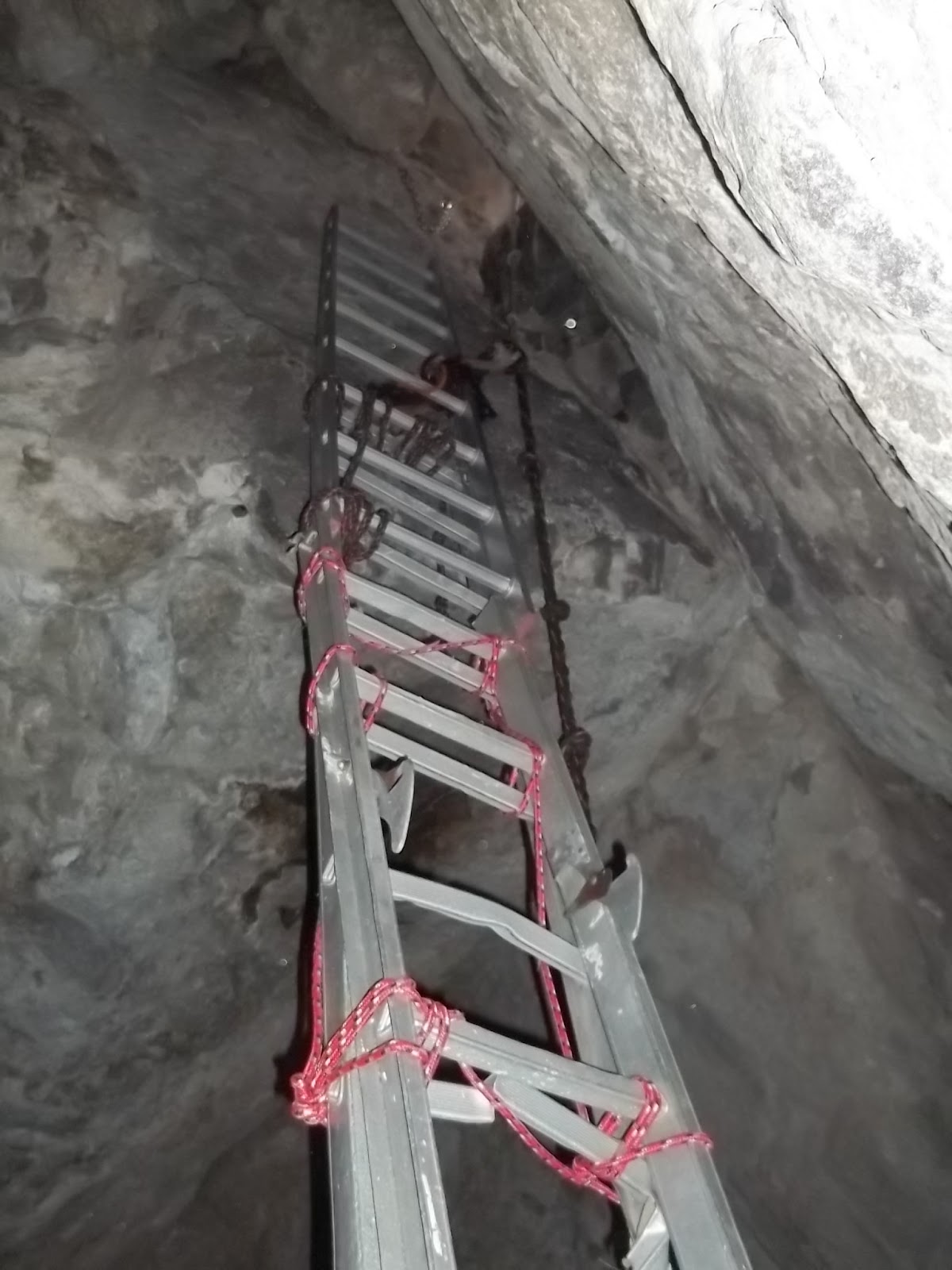
Ladders tied together in Thimble Canyon.

Vic Priebe on the last rap in Thimble Canyon.
 |
| Boundary Cone March, 2019 |
 |
- At the start of the Nutt BM hike I came across a big fat Gila Monster lounging on a rock. It advanced toward me and I had to back up. I couldn't finish the hike with a 20 inch lizard clamped to my ankle. Sadly, no camera. I didn't have one either.
|


