Thursday, October 10, 2019
Nevada's Sky Rock Petroglyphs
Peaks with registers dating back to the 1940s

 |
| These circles at el 11100 indicate the Indians were the first peakbaggers here. |
Saturday, September 28, 2019
White Mountains South
 |
| Active mine and cabin on the south rim of Silver Creek. I could find no trail. |

 |
| Mine road near Sams Spring. That took a lot of dynamite. |
 |
| Rock ring on the south ridge of Black Mtn. |
 |
| One of a half dozen rock rings I saw at a remote location on the Birch Creek rim hike. These are the best rings in the best setting I've ever seen. Only a few elite hikers will ever see them. |
- A paved road runs north from highway 163 on the crest for 10 miles. It allows for several one way hikes down ridges. Shady camps are along the way and at el 8600 is the Grandview Campground. It's free but asks for donations. I filled jugs at the historic Batchelder Spring at mp 26.4 on highway 163. I did every hike on this page in shorts. Nearly every hike has Indian rock rings so be careful to step around them.
- BIRCH CREEK RIM - a one way hike can be done from the Schulman Grove down the rim of Birch Creek. Leave a car at a pullout el 6600 on highway 163 at mp 34.6 then drive to the Schulman Grove on the crest road. The easiest start is the low trail from the visitor center but I wanted to go over Mexican Mine Peak el 10640+. I started at a TH just before the visitor center at N37 22988, W118 10886 el 10050. That trail soon joins the main trail and goes south up to the Mexican Mine then up to a saddle el 10450. It's a short walk south to the summit then it's best to return to the trail and follow it to the rim at 22683, 09619 el 9750. I walked it to 23277, 08780 el 9300 then 23430, 08074 el 8900 then in a third mile I came to a view of the craggy plateau where Indians lived in large numbers. I walked down a wash to a rock ring at 23228, 06968 el 8350 then went south down a narrow drainage that led to the main canyon. I followed that down to a dropoff el 8000 where large potholes had water but turning green from lack of rain. I then went south thru 22854, 06343 el 8050 and into a grassy fork and up that to the duplex at 22327, 06492 el 7950. Then I went up to saddle with a ring at 22242, 06307 el 8050 and saw 3 more along the way. Next, I walked south on the ridge and stayed right of center under boulders and came back to center then saw 3 more rings then a mess of crags was in the way. I easily walked left of those then saw 3 more rings before reaching a flat next to peak 7890. I saw 6 of the best rings there. I walked over to one at 21400, 06845 el 7700 on the rim of the deep canyon to my right. I walked down that rim and went thru 21120, 07013 el 7300 then hit bottom. The canyon goes into a scenic narrows blocked by a fall, so I took a right fork at 20956, 06986 el 6800 then went 400 feet to a main fork and went left. At the next main fork I goofed and went left, but should have stayed right in the main channel to a saddle at 20727, 07086 el 7150 where a mine road was in view. I went down from the saddle for a fifth mile and hit the road and went right on it to mp 34.5 on the highway. It's about a 7 hour hike and a dozen miles that can be done in shorts. If the peak is skipped then there is only about 600 gain of any consequence, mostly near the end. Newer maps show the trails around the visitor center. This is the best hike on this page. Posted 2019.
- DAN BENCHMARK el 8379 sits on the south rim of Silver Canyon. An easy one way hike can be done down the rim from the crest to the mouth. Take US 6 out of Bishop and follow signs to the canyon and leave a car at the mouth el 4400. Then either take the 4wd road up the canyon to the crest or drive 45 miles by way of Big Pine and follow signs to the Bristlecone Forest. Just before pavement ends, park at el 10050 across from a sign on the left that says Black Canyon Trail. The trail splits in a third mile. I stayed right and topped out at el 10200 then walked level thru N37 22781, W118 11797 el 10200 and in another 400 feet I was on the rim. I went down to 22958, 12613 el 9500 and could see a peak below with an OHV trail going over it. I headed for that but took a cycle trail skirting around the right side of the peak and into a saddle el 8150 behind it. The trail drops to the west down a canyon so I left it and walked along the left side of a peak thru 23041, 14350 el 8150 to get back on the rim then on to Dan BM at 23505, 15267. The reg was full of love notes. Just past that at 23534, 15361 el 8250 I came upon an Indian rock ring. That was a stunner. I kept following the easy rim and soon was stunned again by a cabin at an active mine. I could detect no trail for the mine. It was easy to go on down the rim to Silver Canyon Peak el 6890 then to a trail at 24011, 17135 el 6100 and down to the mouth. That took 5 and a half hours and the only effort of any consequence was the 500 feet up to the BM. Some patches of light brush were in the first mile but I could wear shorts thru that. This is just a long cakewalk. The registers need glass jars. Silver Peak Benchmark el 10800+ is the one at the head of the canyon with towers. Drive past the end of pavement and stay left at forks for nearly 4 miles to the top. The last third mile might need 4wd. There are good camps on the west side of the towers. Cold Benchmark el 11000+ is the highest around.It's a short hike to the summit at 23712, 10394. Some hikers use trails out of the Bristlecone Forest but that might entail a fee. Cheap hikers can use a parking area on the west side at el 10300. Posted 2019.
- DAN BENCHMARK WEST TRAIL - miners built a trail to el 7000 on a ridge on the west side. Take the paved Laws Poleta Rd south from the Silver Creek Rd for .7 mile then turn on a good dirt road. Follow it a mile around a fence to a fork at N37 23518, W118 23415, 16425. Go left up into a canyon on mostly smooth 4wd for 2 miles where it tops out el 5700. The trail starts there and in a third air mile it splits. The right fork is easier. At 23415, 16425 el 6800 it splits again, the faint right fork being easier. It levels off next to a saddle at 23450, 16118 el 7000. I stopped there but it looked easy to go on up but a bit steep. Cycles use the trail but I couldn't figure where the miners were going. Posted 2019.
- BLACK CANYON RIM - the west rim is a good one. Drive south from Bishop on US 395 for a mile or two and turn east at the sign for Warm Springs Rd. Drive to the end of pavement then keep going on a graded road as it bends south for 3 miles to the mouth of Black Canyon and leave a car at a pullout there. Then drive nearly 40 miles to the Grandview Campground on the crest then keep going another 1.1 miles to a saddle el 8600 and turn on FR 7S130. That short road ends in a fifth mile where a cycle trail starts reading N37 20888, W118 11260. Walk the trail down into Black Canyon then get on an OHV trail at 20923, 12549 el 7800. Walk that as it circles left into a saddle el 8250 then it goes down the other side. When it veers left, leave it and go to a saddle at 20543, 13224 el 8150 then down into a canyon on the other side and up a steep slope to a flat at 20325, 13830 el 8500. Peak 8840+ is a quarter mile to the west and makes a good side trip. It has a reg in a bag but needs a glass jar. Keep going down the rim and over some minor peaks. At the last wooded peak el 7960+, I skirted along the left side at 18592, 14362 el 7900 then on to 18259, 14579 el 7500 where the rest of the rim was in view. There are some rubbly patches but nothing serious to get down to the mouth. If it was all nice and smooth there would be a dirt bike trail the whole way. I saw 8 rock rings. The last 5 are at 19089, 14019 then 18843, 14070. Two more are in the next saddle el 7850 then a big one is a tenth mile more. That took nearly 6 hours with about 1500 gain with 600 of it strenuous but half that is up the optional peak. Posted 2019.
- BIRCH CREEK PLATEAU el 8000+ is what I call a 4 square mile area south of Birch Creek with a nice forest and rock formations. I was expecting it to be infested with rock rings and wasn't disappointed. I counted 2 dozen just wandering around in the south half and likely missed plenty. This access is off limits to most hikers because only OHVs can get at it but hikers with cars can get in using the Birch Creek rim hike. Take highway 168 to mp INY 33.7 and go up Mollie Gibson Canyon (soft gravel) to a fork at N37 20616, W118 09036. There is a good road on the left bank .27 air mile before the fork. When it dips back into the wash, go a few feet then move to the right channel and go to the fork then turn right. I followed it to a bad spot then started down a ridge there at 22183, 08368 el 8600 and came to a ring at 22220, 08142 then another just past it. Step around the rings to avoid disturbing even a single rock. Next, I dropped into the canyon to the north and climbed up a point at 22274, 07711 then curved left to get on the rim where I could walk NE down an easy canyon. I left the canyon at 22291, 07141 and walked rolling ground to a ring at 22305, 06841. I kept going east past more rings to a duplex at 22327, 06492 then one with a big tree in it at 22406, 06416. 300 feet past that is another good one then I made a U-turn and came back to a sunny one at 22387, 06897. Then I went high to one at 22518, 06990 and stayed high another tenth mile then dropped down to the left to a big one at 22554, 07160. I kept walking nearly level and merged into a creekbed. I could have stayed in that to the exit fork at 22759, 07629 but took a detour by going up a right fork at 22687, 07494 and up to a ring in a saddle at 22733, 07346. Then I went thru a gap at 22813, 07261 to get to the rim of the next canyon for a good view. Then I went up the rim to the exit fork and followed that west and up to a road at 22711, 08026. I walked west on that and down to a tricky T at a wash. I went right a few feet to the road again and back to the start. I spent 4 hours and not much strenous gain. If backpacking I might try coming down from the Schulman Grove then slog out on the road. The only water I saw was a fast drip in a crack at 22310, 07006 but hard to get tubing at it. Maybe there's more downstream. Big rains would leave potholes of water. Posted September, 2019.
- SAMS SPRING MINE LOOP - an easy loop can be done using a washed out road. Leave a car at mp 37.8 on highway 163 then drive to mp 34.6 and park at a pullout. Walk up the highway to mp 34.5 and start up the old road. It goes as high as el 7300 then drops down a wash. It exits on the left at N37 20444, W118 07245 el 7050 then goes into the next canyon and ends at mine structures el 6650. A trail can be seen behind the tall structure. It goes around a corner then drops to a flat with cabin ruins. Then it goes down a point at 20766, 06438 el 6400 and ends at a smooth creekbed. It's easy walking down that to a spring gushing out of a cliff el 6100. It's easy walking the creekbed on to Sams Spring then at the mouth there is a road crossing that can be walked past Antelope Spring back to the start. That took nearly 4 hours with less than 1000 gain, all easy. That turned out a lot better than I was expecting. Posted 2019.
- BLACK MOUNTAIN el 9083 is a short hike. Take the crest road north from highway 163 for .8 mile to FR 4S01B. Go a fifth mile on that then stay left at a fork and stay on the main road for nearly 5 miles to a shady camp area el 8450 near the end, and that's the last turnaround. It's easy 4wd and mtn bikeable. Walk north on the remaining fifth mile of road then game trails continue on to the smooth north ridge of the east peak. Go up to N37 16446, W118 12759 el 8800 where an obvious trail skirts into a saddle el 8700 then it's obvious the rest of the way to an ammo box at 16022, 13503. For the descent, I went down the south ridge. At 15761, 13577 el 8700 I came to a rock ring then another at 15707, 13569. But the first good one is at 15538, 13594 el 8450 with a smaller one 70 feet beyond. Another good one is at 15440, 13606 el 8250 with 2 more in the next 250 feet. There is where I moved right to get near the center of the ridge and walked down to the final leg at 13880, 13861 el 5850 and then to mp 23.3 on highway 163 where I left a cycle. It took an hour to the summit then 2 and a half hours down to 163. Posted 2019.
Sunday, September 8, 2019
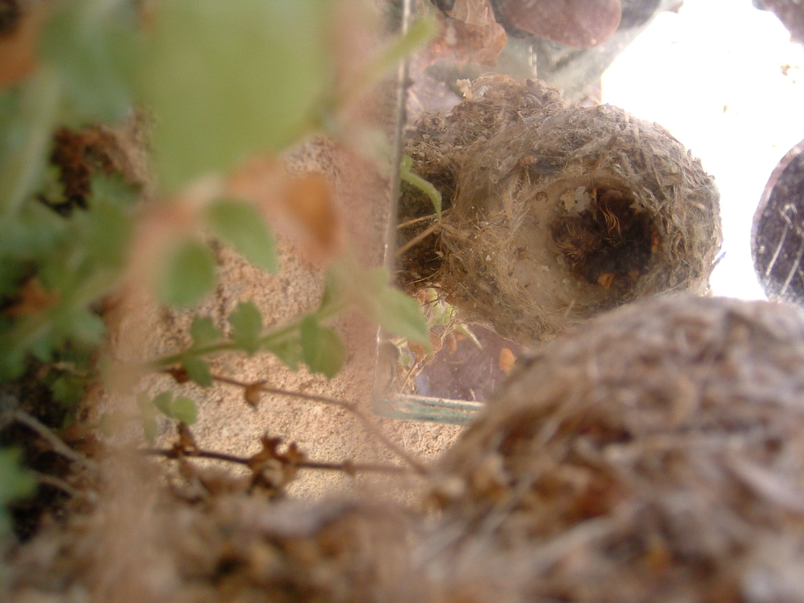
Attack of the Killer Hummingbird


Saturday, August 31, 2019
Mammoth Lakes Area
 |
| Joanne bailed me out of a jam at Valentine Lake. I forgot food but she gave me enough goodies to get me over the hump to Laurel Lakes. Thanks Joanne! |
 |
| White Wing Mtn and Glass Creek Meadow to the left. |
 |
| West Control BM |
 |
| 3 hikers I met on the Mammoth Crest |
- Mammoth has a Vons and also a Grocery Outlet for poor people. The vast area north of town has thousands of camp spots and some free campgrounds. I like the area around Big Spring. For that, take US 395 to mp MNO 32.7 and turn at the sign for Owens River Rd. It's paved for 2 miles to a campground. The spring is gushing out of the south bank of the creek nearby. Posted 2019.
- BLOODY MOUNTAIN el 12500 is south of Mammoth Lakes. From Vons, go south on Old Mammoth Rd to Sherwin Creek Rd, or get on it off 395 about a mile and a half south of the Mammoth turnoff. Take that to the Laurel Lakes Rd at N37 37411, W118 54402. Drive up this rubbly 4wd road for about 4 miles to a trail at 34745, 54337 el 9800. This is a good trail to the pass at el 10700, but switchback cutters are wrecking it. From the pass, go right up the ridge on a hiker trail to the summit at 33638, 54427. 4 hours, 2700 gain. The 4wd road is the hardest part of this trip but there are no big obstacles. I did this in 2013. ALTERNATE DESCENT - I returned in 2020 and descended by way of Bloody Lake. I walked west from the summit where I could see the lake and also down the ridge to the pass el 11300 that is SE of the lake. I descended there with a reading of 33628, 54578 el 12450. That was easy until some boulders near the pass got in the way. They were easy to step down but slow. I went on to the lake and then a passage at 33775, 55316 el 10800 to get thru scrub. I stayed on the right side of the canyon with easy going until a dropoff got in the way but I had been there before. I just headed for a game trail on the left side of the dropoff at 34424, 55115 el 10100. The creek emerges at the bottom of the dropoff. I went down the game trail and stayed high and left of the creek all the way to the first lake then crossed the inlet to the road. I crossed at 34461, 54893 el 9800 and hit a trail on the far bank that soon goes to the road at the lakes. The road goes up a little then it's a short walk back to the start. This return route makes it a 5 hour hike but well worth it. Posted 2020.
- BLOODY MOUNTAIN LAKES LOOP - a loop can be done around the mountain passing by six named lakes. I can't remember a better lakes hike. From Vons, go south on Old Mammoth Rd to Sherwin Creek Rd, or get on it off 395 about a mile and a half south of the Mammoth turnoff. Take that to the Laurel Lakes Rd at N37 37411, W118 54402. Drive up this rubbly 4wd road for about 4 miles to a trail at 34745, 54337 el 9800. Parking is tiny but there is big parking another third mile up the road and the hiking route passes thru there anyway. I walked the trail to a fork just before Genevieve Lake at 33950, 53420 el 10450. Right goes to Edith Lake and could be used on the return, but i stayed left on down to Genevieve where the trail gets spotty on the east shore. I picked it up again at 33538, 52969 el 10100 then went on to a well used trail at 33271, 52957 el 10100 that goes to Lake Dorothy. I followed that to a pass then shortly there is view on the left of Mildred Lake way down below. I stayed on the trail a little more to Dorothy then retraced back to Genevieve and kept going along the shore to 33318, 53192 el 10000 where a trail starts up to Edith Lake. I walked it along the shore to the inlet creek and followed up along the left side of that on a trail. I came to a spring at 33021, 53528 el 10250 and filled up. I went on to 33005, 53632 el 10300 where I jumped to the right side of the creek but there might be a better crossing sooner. That put me on a trail on the north shore of Cloverleaf Lake. I walked that then the shore made a sharp turn to the left, but I stayed straight and soon the shore came back to me. I followed the easy ground to 32965, 54016 el 10350 where I started up an easy slope. I went on to 32983, 54228 el 10500 then 33086, 54281 el 10650. That got me to the base of Bloody Mtn where I could walk to the pass el 11300 and over to Bloody Lake. A fifth mile before the pass there is an obvious shelf up to the left that makes it easy to walk into the pass. I went on past the lake to a passage at 33771, 55315 el 10800 to get thru scrub. I stayed on the right side of the canyon with easy going until a dropoff got in the way but I had been there before. I just headed for a game trail on the left side of the dropoff at 34424, 55115 el 10100. The creek emerges at the bottom of the dropoff. I went down the game trail and stayed high and left of the creek all the way to the first lake then crossed the inlet to the road. I crossed at 34461, 54893 el 9800 and hit a trail on the far bank that soon goes to the road at the lakes. The road goes up a little then it's a short walk back to the start. That took 7 hours with nearly 4000 gain, never steep. Skipping Dorothy would save an hour, but it's the best lake. There is also an option to turn north at Edith and walk a trail that connects to the starting trail. It shows on the sat image. This will never be crowded because the crappy road weeds out wuss drivers. No brush, no wading or bugs in mid August 2020.
- EARTHQUAKE DOME el 9386 has a gorgeous forest the whole way. Take highway 203 out of Mammoth for 2 or 3 miles to a sign for the Earthquake Fault. Turn there and drive a short way to the end at a restroom el 8500. The Mountain View Trail starts to the left of the restroom. I followed that to the west side of the peak and started up at N37 39723, W119 00421 el 8700 and on to the reg at 39974, 00005. That took 100 minutes. The trail is easy then there's 500 steep gain up the slope then it's easy for the last 200 gain to the top. Posted 2019.
- GLASS CREEK TRAIL - this trail goes to Glass Creek Meadow in the Owens River Headwaters Wilderness. It can be used for a loop over White Wing Mtn el 10010. Take US 395 to mp MNO 36.5 and turn at the sign for Obsidian Dome Rd. Stay on the main road for 2 and a half miles then turn right on FR 2S11C and go a tenth mile to the TH with camp areas along the creek el 8150. The roads are tricky for cars but mtn bikeable. The trail stays on the right bank to the meadow. I jumped the creek at N37 44388, W119 02994 el 8800 to get on the left bank then had easy ground in a nice forest to 44102, 03282 el 8900 then to 43978, 03353 el 9000 where I turned directly up the slope and topped out at 43616, 03202 el 9700. Then I went up the ridge to the reg at 43520, 02784. Next, I followed the summit ridge NE for half a mile then moved right of center for the next half mile to 44266, 02184 el 9700 where I descended next to a cairn. I went down the center of a ridge and jumped the creek at 44611, 01827 el 8500 to get back on the trail and then out. That took nearly 4 hours with 1900 gain. I'll put a track on peakbagger.com. I had no trouble wearing shorts but skeeters are gone by late August. The summit ridge has an ancient tree graveyard. Some had been cut, maybe researchers? Posted 2019.
- INYO CRATERS is mainly a tourist attraction. Take US 395 to mp MNO 30.7 and turn on the scenic loop. Go about 3 miles to mp 2.8 then turn and follow signs for 1.3 miles to the TH with a restroom el 8100. Cars can make it. It's a 10 minute walk to the craters el 8200. Miserable hiker trails go up Deer Mountain, but there's an easy route. Walk between the craters to N37 41631, W119 00776 el 8350 then to 41725, 00822 el 8450 then turn right to a drainage at 41722, 00734 el 8600. The drainage leads into the summit crater then a faint trail climbs out on the left to the rim. A level would be needed to figure out the high point. Posted 2019.
- SAN JOAQIN MOUNTAIN el 11549 has a hiker trail running the main ridge from Deadman Pass. That's the standard route and is easiest for hikers with 4wd rigs. Another route comes up from Deadman Creek and makes for a good loop in the Owens River Headwaters Wilderness. Take US 395 to mp MNO 33.7 and turn at the sign for Deadman Creek Rd. Go 6 miles to the end at a TH el 8300 with a camp area which is as good as I've seen in the whole Sierra. The road is graded halfway but most cars could make the whole 6 miles and it's mtn bikeable. The trail crosses the creek on a bridge then goes about 2/3 air mile to the main creek. It follows the creek on the right side but becomes overgrown. I got off the trail at N37 43015, W119 04353 el 8900 and switched back to the right on a game trail and followed it thru the big trees to 43113, 04385 el 9000. I could see a rocky clearing a tenth mile away up to my left. It took me 6 minutes to wade thru light brush to get there then I easily went straight up to the ridgetop el 9300. I followed that ridge up to 43411, 05123 el 10050 where I went left on game trails for a tenth mile to get into a wide drainage. I zigzagged up that and topped out at 43417, 05381 el 10500. Then I stayed low on the right side of the ridge to get to a minor saddle on the final ridge then on up to the reg in an ammo box at 43143, 06367. It took 3 hours, 50 minutes to get there with 3300 gain. Next, I followed the hiker trail on the main ridge to 41966, 05106 el 10500 where I dropped down a wide canyon with the best forest. There are countless routes. I went to 42119, 04666 el 9400 then to the road shown on the topo at 42258, 04415 el 8900. That road was easy to follow back to the trail at 42697, 04036 el 8500. The return took 2 hours, 15 minutes. The whole loop took about 6 hours. I only needed long pants for that tenth mile of light brush. A party with 2 cars could use the hiker trail to get to the summit then drop down my ascent route or keep going to the June Mtn ski area. To access the hiker trail, take highway 203 out of Mammoth toward Devils Postpile then turn right on easy 4wd about 50 feet before a toll booth. The road goes 2 and a half miles to a tiny parking area el 10200 where the trail starts down into Deadman Pass.The road is mtn bikeable, I saw 2 bikers on it. WHITE WING MOUNTAIN el 10010 has routes from the same parking area on Deadman Creek. Follow the creek out of the parking area. A faint road runs along the right bank. Cross to the left bank at 42897, 03349 el then go up to the west saddle at 43390, 03564 el 9400 then up the ridge to the reg at 43520,02784.There's 500 feet of steep sand to get into the west saddle. The unsteepest route is to follow the San Joaquin Mtn hike as far as the ridgetop el 9300 then turn toward the peak. A 300 foot bump is in the way, so either go left around it or nearly over it to get to the west saddle. Going over it has less clutter. I descended the south ridge with no problem. The Glass Creek trail is a good way to access this peak. Posted 2019.
- MAMMOTH CREST makes a fine loop hike.Take the Lake Mary Rd at the west end of Mammoth Lakes. Go about 4 miles from the last light, which is Canyon Blvd, and turn left at the sign for Lake George Campground. Drive to a T then go right to the Mammoth Crest TH el 9000 at the end of the road. Go up the trail and keep right at a signed fork about half an air mile from the start. The trail forks again near the crest. Both go, but left is shorter. The trail goes up to 11200 then drops 600 ft to a basin containing Deer Lakes which is the first water. There seems to be more than one trail to a lake at the upper end of the basin but the main trail stays low along the right edge of a lake then goes to the upper lake. At the far end of the upper lake is a talus slope. Stay low along the base of it and you hit a hiker trail that goes up into the main saddle el 11250. Be on the trail by N37 33558, W118 58838 el 11050. There's a peak 400 ft up to the right from the saddle with good views. The map shows the high point to be at 33280, 58652 el 11600+. It seems to be the highest along the route. Go thru the saddle on the trail as it heads for Duck Pass. The trail fades out in the flats, but just aim for a gully near the pass at 33518, 57823 el 10850 (keep right of brush when you're a fifth mile from the gully) where you drop down and pick up a main trail to the TH at the upper end of Coldwater Campground. This trail is the roughest part of the hike.It takes 5 hours and nearly 3000 gain to go from TH to TH. To get back to the start, go down a road on the left edge of the campground to a T. Go left at the T then follow the GPS back. It takes half an hour to walk back but easy with a bike. Posted 2019.
- VALENTINE LAKE / LAUREL LAKES LOOP - a loop can be done by hiking the Valentine trail to the lake then off trail over the ridge to Laurel Lakes. Take Old Mammoth Rd out of town to the Sherwin Creek Rd and follow that to the Valentine Lake TH at N37 37451, W118 55467 el 7400. Hike to Valentine Lake el 9600 at trails end. The Sherwin Lakes Trail merges in along the way at el 8800. At the lake, go left along the shore, walking on boulders for the first 200 feet, then there is a trail at waters edge. When you get to the inlet creek, climb the slope along the left side of the creek to some nice meadows. When brush gets in the way, it's easy to hop the creek to the right bank and go up and cross back to the left bank just before a talus field where the creek is roaring out. Then stay low on easy ground and finally enter a talus field then climb left to a saddle in trees at 34004,55609 el 10700. Do it right and you only have to deal with talus for a quarter mile before the saddle. Go down the valley on the other side on easy ground and in 2/3 mile from the saddle you come to a dropoff where you can see Laurel Lakes. Aim for a game trail on the left side of the dropoff at 34424, 55115 el 10100. The creek emerges at the bottom of the dropoff. Go down the game trail and stay high and left of the creek all the way to the first lake then cross the inlet to the road. I crossed at 34428, 54930 el 9800 and hit trails on the far bank and stayed on the highest trail that soon goes to the road at the lakes. The road goes up a little then it's 4 miles downhill to the Sherwin Creek Rd where you should have a bike or car waiting. I didn't have a shuttle so to save a mile of road walking, I left the Laurel Lakes Rd at 35821, 55060 el 8800 and walked a third mile thru light brush to a minor ridge at 35963, 55268 el 8850 where I could see a shady OHV trail just below. I walked that to the Sherwin Rd then had a third mile back to the start. 7 hours, 3600 gain with all easy terrain except the quarter mile of talus. And that's stable and no big deal. I did it all in shorts but the shortcut at the end needs long pants. I had pants in my pack but it was borderline and I got thru. There's no brush at all with a shuttle but Valentine Lake had a few mosquitoes. The Sherwin Lakes TH is nearly 400 feet higher but starting there would need a shuttle for sure. That's a longer trail. Posted 2019.
- LAUREL LAKES to CONVICT LAKE - A trail connects the lakes. It's the best all trail hike for day trippers around Mammoth. I downloaded the map from peakbagger for Laurel Mtn to cover the area. The topo is generally accurate except at Mildred Lake the correct trail runs on the north shore. I left my truck at Convict then rode my cycle to the TH el 9800 on the rough road to Laurel Lakes. I walked the trail to a fork at N37 33956, W118 53429 el 10400. Left is the trail on the topo and it goes directly to Genevieve. I took the right fork that goes to Edith and then on to Genevieve where it merges with the trail on the topo. I followed it to Dorothy then down to Mildred but I took a side trip to a waterfall draining out of Dorothy. I left the trail at 32862, 52706 el 10200 then down a slope at 32873, 52654 el 10000 to get to the creek. Then I went up creek for 5 minutes to the fall. It's at 32899, 52700 el 10000. I couldn't tell if it can be reached from the top down but it can't be reached from the sides. I went down the creek to Mildred and resumed on the trail. A sixth mile past Mildred is a gushing spring below the trail where I filled up. The trail goes on down and crosses to the left bank at bridge ruins then on to Convict where it forks and the correct fork depends on where you spotted the car. That took 6 hours and the peakbagger app said it's 12 miles with 2700 gain and a mile of loss. No bugs and no wading in late August. The next day I drove to the Sherwin Lakes TH and did the Valentine Lake to Laurel Lakes hike and that got me back to my cycle. It took 5 hours. I got two great lake hikes for the price of one shuttle. Posted 2020.
- MILDRED LAKE TRAIL - this rocky but easy trail goes from Convict Lake up a spectacular canyon. Go SE on 395 for a bit over 4 miles from the Mammoth turnoff to a big sign for Convict Lake. Follow signs on a paved road to the TH el 7600. The trail runs along the north shore then a sign points up canyon to Mildred. The trail stays on the west bank to a fork in the creek el 9000 where a huge bridge washed out. There are two crossings close together at that point. The trail resumes on the east bank at N37 33530, W118 52334 el 9050. It swithches up then on to the lake at 32787, 52399 el 9800. A sixth mile before the lake I filled up at a gushing spring below the trail. That took 6 hours with 2200 gain. The two crossings were barely jumpable. Posted August, 2020.
- MOUNT AGGIE el 11565 is a wuss hike if you have a jeep or OHV. Turn off 395 at the big yellow sign for Mount Morrison Rd. It's a about 6 miles SE of the Mammoth turnoff. Go a short way then turn left at a cemetery to get on the powerline road. Go SE less than a mile then the road gets close to 395 and meets road #4S48. Follow that up a canyon but don't take a steep left fork. Soon it opens up and you'll see the switchbacks. It's not steep to the top but it gets loose at 9400. After that it levels off then stay right at forks to the end where the road is blocked at a fork el 10400. Mount McGee is an easy stroll to the left at 34015, 48665 el 10886. Use the right fork for Aggie. The road fades in half a mile on the ridge top. Follow the easy ridge to where it steepens. Then angle right thru trees to a game trail at 33155, 50508 that angles up to the ridgetop. Now it's a short stroll to the summit 32746, 50575. 3 hours and 1300 gain. I could have easily drove a jeep to a turnaround at 35338, 49046 el 9100. Slides are creeping onto the road beyond there. Any 4wd can make it to the start of the switchbacks at el 7800. The low road goes on to a sunny camp with a table overlooking Convict Lake at 35205, 50908 el 8250. Posted 2020.
- BALD MOUNTAIN el 9105 has an easy 4wd road to a public cabin on the summit. The best route would be to use the Bald Mtn Rd at mp MNO 36.5 on US 395. I went in from Big Spring Campground and followed signs. Posted 2019. In 2020, the road was gated at the last mile el 8700, thanks to vandals. But they can drive around the gate.
- EARTHSCOPE PEAK el 8508 sits next to US 395 and has an easy 4wd road to the top. Turn off at mp MNO 36.5 and go NE on Bald Mtn Rd for a mile to FR 2S119. Go left for a mile and a half to the summit with equipment to measure tectonic plate movement. The last bit is steep. Posted 2019.
- COMM TOWER PEAK el 8478 sits next to US 395 and has an easy 4wd road to the top. Turn off at mp MNO 34 and follow FR 2S21 for 2 and a half miles to a fork then go left on pavement for the remaining half mile. Posted 2019.
- LOOKOUT MOUNTAIN has an easy 4wd road to the top. Take US 395 to mp MNO 30.7 then go east and north on the main dirt road to a fork at N37 43083, W118 56822. Go left there on FR 2S02 and it's 2 miles to the summit. Posted 2019.
- WEST CONTROL BENCHMARK el 8571 is related to the Mono Craters Tunnel. Turn off US 395 at mp MNO 39.7 and go a third mile on pavement then go left on graded road for a mile and a half to the Punch Bowl on the left. Keep going on the main road for 2 and a half miles to a fork at N37 50221, W119 00067 then go left for a mile on easy 4wd to the BM at 49946, 00665. Structures there are dated August, 1932 and the BM is dated 1933. Engineers reports from the 1930s about the tunnel are online. It's 11 miles long and 9 feet in diameter. Posted 2019.
- SENTINEL MEADOWS PEAK el 10200 is west of Glass Mtn. Road #1S17 is the main road running along the north side of the peak thru Crooked Meadows. Turn off that road at N37 48296, W118 47400 onto road #1S51 and go south to the next fork and go left on road #1S51C. It goes over peak 9255 and ends at el 9250. Just go up the ridge. It goes parabolic then levels off at el 9700. Stay left of some minor bumps to the reg at 46686, 46516. It's in a can that will get soaked. I took a direct route back down a ridge at 46978, 47097 el 10000. 2 hours, 15 minutes with 1000 noticeable gain. Nice forest. Crooked Meadows has a good campsite with a table along the main road. Posted 2020.
Subscribe to:
Posts (Atom)