Search This Blog

Thursday, February 21, 2019

McCoy Mountains

Bluebird Mine


Rock was blasted out then sealant applied.


  • A frontage road with power lines along I-10 accesses the southern part of the range. It starts at the Wiley Well exit and runs east to exit 232. In between,  road #1081 goes thru a gap in the I-10 fence at N33 36621, W114 49470. That's dangerous for eastbound drivers and likely not legal. They should proceed to exit 232 and come back. The frontage road is generally easy but has sandy spots. The north side is accessed using the Lovekin exit at Blythe and following pavement north. The west side is largely blocked by wilderness. Posted 2019.

    • PEAK 721 meters dominates the southern end. The south ridge is easy. Use the frontage road to get to N33 36791, W114 50700 where a road goes north up a channel. But take the one running parallel to the right of it and it will pull away and go nearly 2 miles to old cars. A rough crossing is there then 3 forks on the far bank. Take the middle one reading 38316, 50299 and go half a mile to another fork el 600. Take the one going up the hill and follow the road north to the end where it makes a loop. Cut left into a canyon and go up a bedrock gully at 39294, 50650 el 1000. Go up to 39430, 50808 el 1500 where the rest to the main saddle and up to the summit is obvious. The reg is at 39785, 50569 el 2365. Placed by M&L in 1979, Bob Burd came in 2015 and that's it. 3 hours, 1800 gain from the fork at the hill with hardly anything steep. The roads are mtn bikeable. The SW ridge could be an alternate route but it's rough. Posted 2019.
    • McCOY PEAK is next to I-10. Exit at Wiley Well Rd. Go left around the rest area and around the west end of a dike then east behind the dike keeping right of a kiosk and dunes. Soon the road goes left across a wash to a power line road. Go right on the power line road for a few feet then take a left and go a mile to a hidden road at N33 37571, W114 53377. This hidden road is just before a stone house. Go east for half a mile to a T at a post. Now go left. In about a mile the road swings to the right across a wash and on toward the peak. The road ends at a canyon west of the peak. Hike up the old track at 38777, 51918 then canyon to a right fork at 38890, 51576. Go up that to the ridge then go right keeping left of a bump. Climb up and around to the north side of the summit block and go up into a notch at 38971, 51200 then right to the top el 2000+. 3hrs, 1300 gain. All roads easy 4wd as of 2013.
    • PEAK 409 meters is a twin summit east of McCoy Peak. A mine road goes nearly all the way up. Use the frontage road to get to road #1081 at N33 36790, W114 49473. Go north on that for half a mile and stay left at a main fork and go to the mine road at 38330, 49672 el 700. Walk it a fifth mile then it switches back then stay on that trajectory and it ends at the bottom of the 0 on 407 shown on the topo. It's a short walk to the saddle between the summits. 75 minutes, 700 gain. PEAK 433 is in view to the east with a tower on it. Use the frontage road to get to 36782, 47492 then drive north for 2 miles to a saddle with a gate el 750. Walk up to the tower el 1300 then up the ridge to the peak at 38446, 47761 el 1421. 1 hour, 700 gain. An Indian trail cuts thru the saddle. I walked it east down the canyon. It's on the south side at first then goes to the north side at the bottom. I followed it thru a saddle at 38209, 46957 el 650 then on to the flats where it fades. That's the longest stretch of unmolested trail I've found for that trail. It looks like a million Indians went thru there. It starts at the river and cuts thru the Big Maria Mtns then goes around the south side of the McCoy Mtns to the spring. Another branch of the trail cuts thru a saddle to the south. It can be seen crossing the road a half mile before the gate. These roads are mtn bikeable and easy for 4wds. Posted 2019.
    • McCOY MOUNTAIN el 2828 is the highest peak. An old coot route goes up the NE ridge. Exit I-10 at exit 232. Get on the paved north side frontage road and go west a mile and a half to a sign for Dracker Rd. Go north on pavement for 5 and a half miles to a gate blocking the road at a solar site. Go west then north along the fence to a faint road at N33 42357, W114 46594. Keep going on the road to a faint track on the left at 42581, 48991, which is just before a deep gully. Take that for a mile to a T el 850 at the base of the range then walk to 41874, 50309 el 1200 and start zigzagging up the ridge. A shelf near the top at 41448, 50718 skirts under crags then the reg is at 41360, 50674. 4 hours, 2000 gain, not very steep. The 5+ miles of dirt road are mtn bikeable and easy for 4wds. Drive back the same way to avoid rocks and gullies. RV camp areas are along Dracker Rd, the best being 2 and a half miles in from the frontage road at a sign for Rose Way. Take plenty of extension cord to plug into the solar site. Posted 2019.
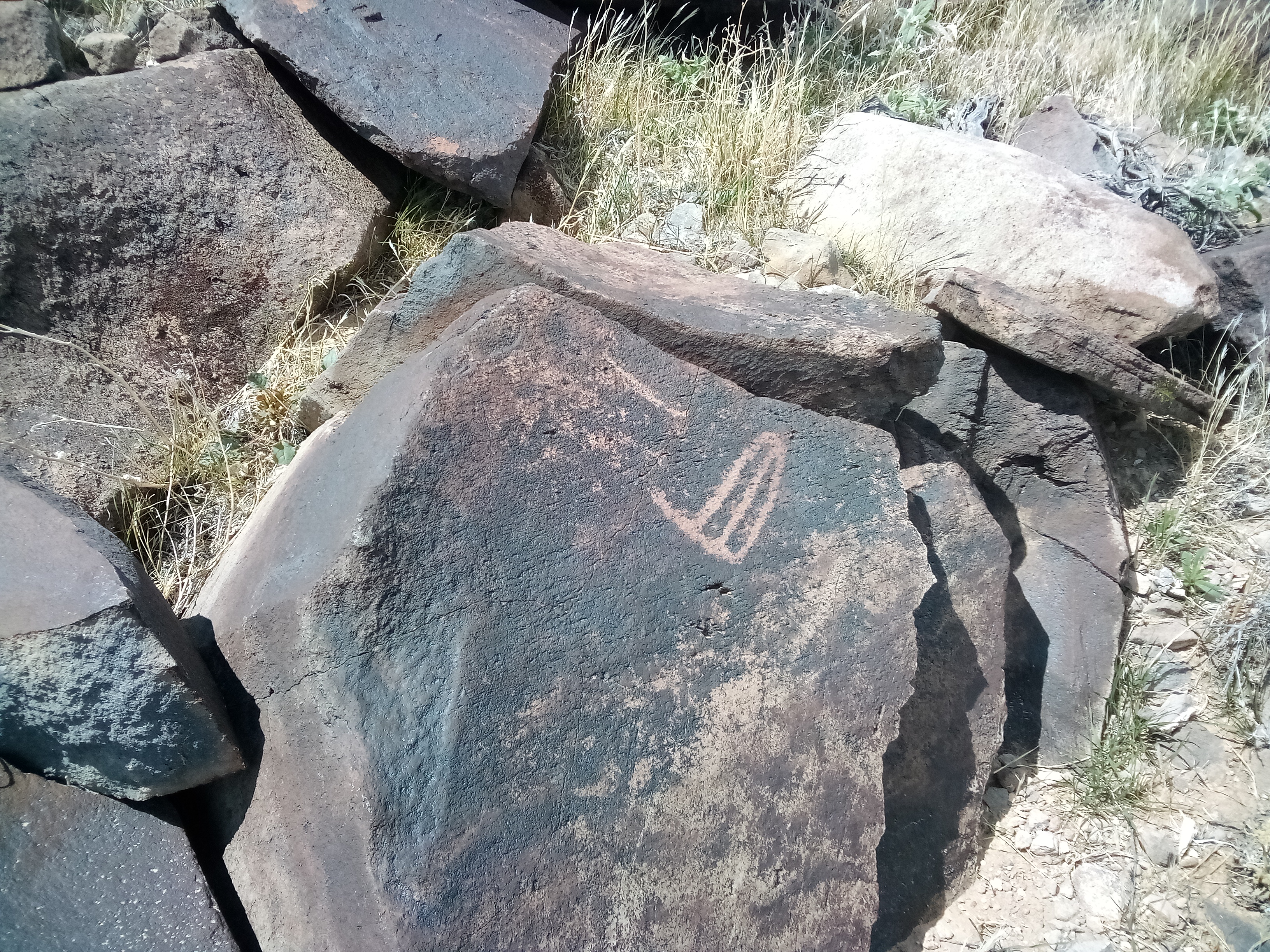
    • BLUEBIRD PEAKPEAK el 812 meters is what I call the northernmost of the 800+ meter peaks. A mine trail goes to the south saddle el 2200. Take the Lovekin exit at Blythe and go north on pavement for about 18 miles to a sign for the Standard Mine. Go west there on graded road for a bit over 7 miles to a main fork. Go west for 3 and a half miles to another fork and stay right. Now just follow major roads that circle around the north tip of the range to a canyon on the west side with cabins. The last turnaround is a foundation with plenty of nails at N33 47911, W114 56183 el 1050. Walk on up the washed out road to a mine at the end with a winch still intact. Just above is the trail angling up left to right reading 47983, 55719 el 1750.  It goes up with no major switches and tops out at the saddle reading 47828, 55376 el 2200. Now it's just a class 2 ridge up to the reg at 47944, 55355 el 2664. Another trail can be seen in the canyon to the south for a loop back. Retrace to the saddle and go left on the trail a short way to a minor tunnel then drop down the canyon on decent terrain. Trail fragments start showing up on the left bank around the 1600 level then the route goes over to the right bank. At 47605, 55468 el 1450 the trail becomes obvious and soon cuts over to the left bank then back to the right bank at the mouth. It's an easy stroll on down past a rock dwelling then a trail goes thru a gap to get back to the start. That took me 3 hours, 11 minutes with 1600 gain. The 8+ miles of unmaintained road are mtn bikeable and easy for 4wds. The main high trail goes on past the saddle el 2200 and crosses a ridge at 47833, 55089 el 2500. It then drops down the other side to el 2300 and seems to end. A lot of turquoise rock is along the trail and some boring mines. Posted 2019, 2021.
    • PEAK 2710 ( Alzheimers Peak ) is 3 and a half miles SE of St Johns Mine. It's one of the elite 800+ meter peaks. The long canyon from the mine is an  easy route. Take the Lovekin exit at Blythe and go north on pavement for about 18 miles to a sign for the Standard Mine. Go west there on graded road for a bit over 7 miles to a main fork. Go left for 50 feet then left again on a crude road hooking back to the south. Follow it 3.3 miles to the bank el 1100 of the long canyon. It's easy 4wd but for one crossing at the last half mile. Walk up the wash a fifth mile then get on the left bank and pass under the mine. The left bank works intermittently but be on it again at N33 45345, W114 54326. Soon there is a trench to cross so drop back to the main wash and come up the trench a few feet to get back up and then a second trench can be crossed at 45013, 53944. That will play out then get on the left bank again at 44686, 53831 and next get on the right bank for the first time at 44555, 53382. The peak is in view and it's best to go up the west side. I circled to the south side but had to deal with crags. The reg, at 44450, 52395, was placed by M&L in 1985. No surprise there, but the only other entry was a stunner. It was my name from 2009. What? I have no recollection whatsoever. I must have come up the east side to the south saddle. It's easy to walk north for a fifth mile from the reg staying mostly left of center to the first major saddle el 2400. I wanted a loop back along the base, so I descended east down from there to a gully at 44616, 52451 el 2200 then dropped to the left down that. The canyon eases up and it's easy to walk the left bank to a ghost road at the mouth. It might be best to use the road, but I shortcutted across the flats to a trench crossing at 45398, 51622 then drifted right and hit the road. It runs north along the base then starts curving east, and I should have got off it there and went staight to the next trench crossing at 46173, 52331. Then there's one more easier gully to cross on the way to the point then cross a gully at 46859, 52452 and then the last trench crossing is at 47087, 53509. That took me 7 hours, 20 minutes and 800 feet up the peak plus several trench crossings is the only strenuous gain. But that will come in under 7 hours next time because I know the route. It's hard to find a pristine canyon as big as this. And a lot of good pavement too. It rained 2 days earlier but I saw no water. A drill pipe at 44781, 53843 and cairns are the only human impact I saw in the canyon. PEAK 817 meters is the next one south and the north ridge looked easy. I didn't do it (I don't remember doing it), but my route up the south side of peak 2710 gave me a view. Stay in the long canyon and use the right bank at 44402, 52963 then cut over to the right bank of a left fork at 44294, 52840. In a fifth mile up that fork it opens up on the east side of peak 616 with easy ground to the north ridge. I betcha there's a reg on that one too. Posted 2019. SHORT VERSION - an easier loop can be done by skipping the peak. Leave the long canyon at 44621, 53452 el 1650 and walk along the bank of a side canyon to 44902, 53254  el 1750 where a route up a gully to the east goes to a saddle el 2150 on the crest. Then walk south on the crest on a faint trail to 44912, 52968 where an easy ridge goes down. At a major saddle el 1400, drop off the ridge to the right and walk smooth ground to a point where it's easy to drop off the left side and cross the main wash. Keep going to a ghost road that leads to a T. I decided to circle way out into the flats on easier ground and it took me an hour to get to the point, which is an air mile and half away. The more direct route might save 15 minutes but is rougher. I went to 45621, 51590 then 46178, 51354 and then went north a third mile where I could turn back toward the start and go with the flow of the gullies. I went to 46625, 51813 then crossed a gully at 46648, 52038 then another at 46859, 52452 and then on to The Trench (which is skippable) near the start at 47087, 53509.  I went down that for 250 feet to a pothole with a minor class 3 drop. It had the only water I've ever seen in the range. Miners used it. It's a fifth mile down to an exit then a short walk to the start. That took me 5 and a half hours with 300 feet of strenuous gain. It's just a long, easy stroll in a wild place and the best pavement I've ever been on. Posted 2019.
    • BLUEBIRD MINE - This hike starts at the same spot as the peak 2710 hike.  Walk to an old road at N33 47364, W114 54388 el 1250 and go up to rock dwellings where the road crosses a deep gully, but a trail on the right bank is more appealing.  It goes a third mile and fades where the mine is in view. Walk on up toward the mine and meet the road again and the trail  goes up the right bank there. It will cross to the left bank and stay there to the mine el 1950. A dam and a long tunnel with rails are there. 2 hours, 500 noticeable gain. St JOHNS MINE - the trail starts at 47117, 54140 el 1200 and gains 250 feet to the tunnel. Short hike. Posted 2019. THE TRENCH is nearby also. Walk to 47263, 53431 el 1100 and drop in. It's a fifth mile up to a minor class 3 fall and pothole then a trail exits to the right just past that. That pothole had the only water I've ever seen in the range. Posted 2019.


      Residents at The Trench

      The Trench

      1996 map
      Compressor and dump truck on the Bluebird Peak hike.

      Mine on the Bluebird Peak hike.

    Friday, January 18, 2019

    Trigo Mountains Wilderness


    Needles Eye and Bobbin in the background

    White Rock Canyon


    First rappel in Bridge Canyon

    • A west side road accesses the area. Use the exit for highway 78 west of Blythe. Go south, no turns, and cross a river bridge where the road becomes River Rd. It goes 8 more miles to the end of pavement where RVs can camp with TV and VZ signals. A graded road continues south another 7 miles then it's 4wd on thru to Yuma. Another way in is a graded road at mp 77.5 on highway 78 just south of Palo Verde. Many peaks on this page are in the Yuma Proving Ground. The policy in effect seems to be "don't ask, don't tell", but the Army isn't liable if anything goes wrong. OHVs penetrate miles into it and hunters are legally allowed in. The peaks are in good condition but burros have trashed everything else to varying degrees. A wilderness it ain't. Posted 2019.
    • MOHAVE PEAK el 2768 is the high point of the Trigo Mtns and well inside the YPG. The west canyon on the south side of peak 2195 is easy then the SW side works for the summit block. The best approach I found is a well used jeep road running thru Crazy Woman Wash from the NW. I saw two jeeps and two ATVs on it. They said they ride thru there all the time. A 4wd road goes to it from the Cibola dump, but a much better road starts at mp 6.1 on River Rd. Go 5 miles on it to a T then go left on a wide road for .4 mile then go right for a fifth mile to N33 20607, W114 34819 which is where the sign is for the YPG, which everybody ignores. The road goes on another mile and a half then enters the wash at 20643, 33662 el 750 where rocky patches slow things down. It's easy 4wd that far but would be 8 miles to the peak. There's nothing to stop a jeep going all the way thru and then they apparently turn north to the public road cuttting across the YPG, but I didn't go that way. Parking at the YPG boundary would mean a 9 or 10 mile hike one way. Backpackers would find water at the Louie Coor guzzler reading 19188, 31777. It had fish in it. The biggest pool I saw was at 17645, 31780 and 3 feet deep. More smaller ones were just past it. A parallel canyon had a big pothole at 18591, 32108. That canyon could work as a return route, but has rocky stretches. The west canyon had bathtub size pools starting at 16588, 30109 and burros can't get to those. Another approach is the Black Diamond Mine road. It's closed at the wilderness boundary at el 750 but signs are long gone and everybody keeps driving. Jeep tracks go all the way to Lopez Wash. I saw potholes on that route, the best one at 14878, 31729 because it's hard for burros to get at. A grand loop could be done up Crazy Woman and out Lopez. I would drink any of the water after filtering, but it had rained two weeks earlier. Christmas or Thanksgiving would be good times to go when there's nothing going on. The reg was placed in 1993 by a Sierra Club group. It had six entries since. Posted 2019.
    • CRAZY WOMAN PEAK el 2007 is what I call the crag peak on the north side of Crazy Woman Wash. Use an easy 4wd road at mp 6.1 on River Rd. It follows an Indian trail that is still visible despite the burro onslaught. Go 5 miles on it to a T then go left on a wide road for .4 mile then go right for a fifth mile to the sign for the YPG, which everybody ignores. The road goes on another mile and a half then enters the wash next to the Indian trail. Walk from there to a flat at N33 20764, W114 33445 el 750 then on to the bank of a wash at 20881, 33208 el 800. Walk that into a canyon then go up to class 3 rock at 20936, 32141 el 1200. Climb up that to get into a bedrock gully and go up to the NE saddle at 20786, 32000 el 1800. An obvious class 3 route goes up to the summit cairn but has one exposed move. Take a 20 foot line for the squeamish. Sheep go up, how hard can it be? 4 hours with 1000 noticeable gain. For an alternate descent, the south canyon has huge potholes up to swimming pool size. Aim for the canyon at 20382, 31831 el 900 then walk downstream past the potholes back to the start. I found the potholes on a separate hike. The wide road goes to Cibola but has bad crossings. The Indians were likely walking to Mohave Tanks. I've seen grinding holes there. Posted 2019.
    • BOBBIN PEAK el 2562 is north of Needles Eye Peak. Take River Rd to mp 7.1 and turn on easy 4wd reading N33 18758, W114 39707 el 250. Go 4 and a half miles, keeping right at a tricky fork along the way, and go left up a wash at 18999, 35240 el 700. Mtn bikes could make it that far. Go half a mile up the wash where a slide blocks vehicles. The route up is obvious, the following waypoints are for hikers who might want to do it in a blizzard. Walk on up the wash and go left on a trail at 18777, 34578 el 800 and stay on the low ground to a sheep route at 18803, 33908 el 1050 that runs on a shelf along the base of a cliff. A bee hive was about 2 or 300 feet further along at the base, so it might be better to stay low to get past it. Just follow the shelf along the cliffs to the north saddle el 2150 then go up the ridge until it gets ugly then angle to the right up to 18639, 33427 el 2400 and on to the reg at 18606, 33383. That took us 3 and a half hours with 1500 noticeable gain. The bees didn't strike until the descent, but I was wearing yellow by then. I got two stings, but I've had worse mosquito bites. These are wuss bees. The road goes on to the Hart Mine then on to the Black Diamond Mine road, but there are many sharp dips. Posted 2019.
    • HART MINE ROAD - this good road starts at the end of pavement on River Rd. It goes 3 miles to a large quarry, not the Hart Mine shown on the topo. Then a 4wd road cuts over to the Black Diamond Mine road. Posted 2019.
    • NEEDLES EYE PEAK el 2539 is what I call the Chocolate Benchmark. It's the most dramatic peak in the area. Go south on River Rd for about a mile south of the end of pavement to a main fork. Go left on graded road for 2.3 miles then go left 1.3 miles to a main wash. Go 2.2 miles to the end of the legal road and walk up a left fork near there reading N33 16322, W114 35365 el 750. After a fifth mile there are potholes and a trail on the left bank bypasses them. Go on to a left fork at 16347, 34891 el 850 and on toward the peak and climb out on the right at a fall 16436, 34402 el 950. Keep going along the main creekbed using the right bank to bypass an occasional fall or boulder jam but stay near the creekbed. The canyon goes parabolic and tops out at a flat el 1750 a half mile south of the peak. Go left toward the peak keeping right of a crag. Go behind the crag to a saddle el 2100 then another saddle at 16554, 33792 el 2200. Drop a little and walk to the SE saddle of the peak to an easy class 3 chute at 16705, 33763 el 2300 then go up to the peak 16763, 33793. The final block has some more class 3. M&L placed a reg in 1981. No one had signed in since my visit in 2008.  5 hrs,1800 gain. 2wds and mtn bikers would have a 7 hour hike. Backpackers could use the potholes at 16342, 35151 el 750. They run for a tenth mile and up to 3 feet deep. They looked OK but floods will send burro poop into them. Burro impact was light but that can change. Posted 2019. PEAK 1744 can be hiked from the same parking area. Use a trail at 16359, 35522 el 750 that starts up a canyon. Stay in the main canyon past huge potholes as it circles to a saddle at 16169, 35686 el 1050. Then go directly up on steep bedrock and a faint sheep trail to a gully at 16158, 35818 el 1400. Go up that to the crest at 16186, 35869 el 1500 then it's just a stroll for a fifth mile NW to the reg. Placed in 1999, it had no entries since. 2 hours with 800 noticeable gain. All the bedrock makes this a pleasant hike. One of the big pothholes at 16261, 35492 el 850 is inaccessible to burros, though they rarely visit the canyon anyway. Posted 2019. PEAK 2020 is to the south. Walk the jeep road which is running along the east bank. At the next side canyon, get on the high right bank at 15965, 35212 el 800. The bank ends in a tenth mile then a constructed trail goes on a fifth mile to a big waterhole that burros can't get at. Walk past it on the left then up canyon to a right fork at 15717, 34662 el 900. Go up that to the valley at the foot of the peak. Only one easy route is in view and it's up the SW ridge. I went thru a saddle at 14844, 33947 el 1300 then up to an obvious saddle el 1500 on the SW ridge. There are no big dips on the ridge all the way to the reg at 15028, 33707 with no entries since 1999. Surveyor junk is past it. 4 hours, 800 noticeable gain. Posted 2019.
    • BLACK DIAMOND PEAK el 1920, next to the Black Diamond Mine, is what I call the high point of the wilderness. A class 3 gully goes up the west side. Go south on River Rd for 2 and a half miles beyond pavement to where the road bends right. Stay straight on easy 4wd for .6 mile to a mega wash reading N33 15519, W114 39552. Go 2 miles up the easy wash, staying right at forks, to a fall at the end of the road el 350. We climbed the fall just to prove that we're men, but there's a trail at 15314, 37814 on the south bank that's faster. Keep going east on the low ground past a peak with a double eye then next is a crag. Follow a trail along the left side of it in a wash and go on using trails to a minor saddle at 14847, 37169 el 650. Go thru on a trail then up a fork at 14804, 37004 el 650 that goes over a saddle el 750 into another canyon to the south. I call that Bridge Canyon. Burro impact is almost nonexistent by this time, and you'll start to think you're in a real wilderness. 5 minutes downstream is a major fall with a bridge. But go upstream and stay right at main forks to the end at a saddle on the west ridge reading 14408, 36193 el 1200. Go up the ridge using bedrock to the right of center all the way to cliffs blocking the way at the summit block. Go left along the base on faint trails to a palo verde tree at the final gully reading 14613, 35902 el 1700. A minor fall blocks the gully, but 50 feet beyond the tree are at least two class 3 chutes to get above the fall then it's simple to go up to the cairn at 14643, 35873. That took us 5 hours with nearly 1000 feet of strenuous gain, but no backsliding. It would only add an hour to rappel back down Bridge Canyon. The canyon has some potholes upstream from the technical section, the biggest was bathtub size at 14663, 36714 el 750 and no sign of burros ever, but occasional burros have been upstream of it. Vic Hanson posted a GPS track on peakbagger.com, but it doesn't show the best trail I found later. Posted 2019.
    • BRIDGE CANYON RAPPELS - three fun rappels are in a short section of the canyon. They're not quite vertical and have easy launches and good anchors. Start at the same parking spot as the Black Diamond Peak hike and use the same trail at N33 15314, W114 37814 on the south bank. Keep going east on the low ground past a peak with a double eye then next is a crag. Follow a trail along the left side of it in a wash and go on using trails to a minor saddle at 14847, 37169 el 650. Go thru on a trail then up a fork at 14804, 37004 el 650 that goes over a saddle el 750 into Bridge Canyon. Walk down the creekbed for 5 minutes to the first drop. It's 90 feet with an anchor 25 feet back. A bridge is at the bottom. An escape route heads up the south rim there. The next 2 drops are shorter then some class 3 is next to get down to the bottom. Soon there is a trail on the left bank. Use that to get to another trail on the left bank of a side draw at 14604, 37279 el 500. Follow that up over a low saddle el 650 and it joins the approach route then retrace back to the start. That took me less than 3 hours with 4 or 500 feet of noticeable gain, not steep. I used a 200 foot rope and a pull cord and about 20 feet of webbing. I ran out of webbing at the last drop and used pull cord. A 150 foot rope and pull cord with 25 feet of webbing should do it. Using a 200 foot rope doubled over would mean using a scary horn at the lip of the big fall, or extending the anchor I used but that would be an eyesore. It would be hard to get trapped in this canyon. Posted 2019.
    • WHITE ROCK CANYON is what I call an interesting canyon on the west slope. A loop can be done starting in the same mega wash where the Black Diamond Peak hike starts. Drive that route until the last mile then walk up a fork at N33 15559, W114 38484 el 300. Go up canyon to a trail at 15631, 37173 el 600 that goes up a left fork. In a tenth mile it goes over a saddle el 650 then goes down on the left side of the drainage and hits bottom. Walk on down canyon and get on the right bank at 16175, 38038 el 400. In another tenth mile there is a shallow narrows that runs for a quarter mile. Walk thru it for a thrill then there is a shorter one at 16128, 38460 el 350. Now just walk south over a bench to a trail at 15766, 38387 el 350 that goes back into the starting wash. That took 2 hours and nothing steep. A corpse could do this hike. Don't be suprised to see me on it when I'm dead. Posted 2019.
    • LOPEZ WASH cuts a deep gorge thru the wilderness. Various loops can be done. Drive south on River Rd for nearly 7 miles from the end of pavement to where the graded road ends. Keep going on a crude road for 1.3 miles to a fork at a kiosk. Go left for 1.4 miles and park on the west bank of the wash reading N33 13035, W114 38404 el 400. Mtn bikes can make it. Drop down on a trail and walk down the wash and exit on a trail at 13374, 38319 then go north a third mile to another wash. Get on the left bank at 13760, 37971 and go east toward a mine road going up a minor ridge. Follow that road as it winds thru rugged terrain and ends at a boring mine. Walk a 100 feet more to a rubbly gully and go down that to the canyon floor. We  then went up the other side of the canyon on a trail and on thru the main saddle at 13739, 35689 el 850 and down the wash to a minor fall. A class 3 ledge goes down the right side of the fall then it's a short walk to Lopez Wash. But for the mines, don't go down. Instead, go left to a tunnel at 13128, 35524. It has ladders and skylights. Follow a road down from there to Lopez Wash. The next tunnel is on the right bank at 13036, 35517 with some wooden chutes in it. On the opposite bank is a wench and trail going up the drainage to a huge tunnel. A shaft in that one has a wooden cover. Follow the wash back to the start. One more peculiar mine ruin is on the right wall way downstream. That took us 5 hours, 20 minutes with hardly any strenous gain. Someone cut the refuge fence making it possible to drive into Lopez Wash. The wash is soft gravel and burros keep it that way. The road goes on down the west rim of the wash to a washout at 13790, 39459, but there's another road where someone cut the refuge fence making it possible to drive into Lopez Wash. Posted 2019.
    • COXCOMB MINES are south of Lopez Wash. Drive south on River Rd for nearly 7 miles from the end of pavement to where the graded road ends. Keep going on a crude road for 1.3 miles to a fork at a kiosk. Go left for a mile to a T then go right for a fifth mile and park at a bad spot el 400. Walk south down the road to a major wash and go up that to a road on the left bank at N33 11896, W114 36740 el 600. The road goes to the mine area with a camp at 12227, 36650 el 650. A winch is at 12404, 36705 el 750. A high mine is above that at the top of a talus slope, but I skipped it. Around the corner is a tunnel at 12307, 36548 el 750 with rails and a gelatin box. Not just any old gelatin, extra strength gelatin. Next to it is a workshop in solid rock with a steel door. The last mine of interest has a road at 12270, 36353 el 700 that goes thru a canyon and circles up to a shaft in a saddle reading 12251, 36197, el 900. It has a homemade ore bucket. For Coxcomb Benchmark el 1030, retrace back down the major wash and exit at 12070, 37639 el 500 and go up to a saddle el 750. It's obvious how to go on up to the reg at 12352, 37791. A fast way back down is to circle around to the north side of the summit block to a trail that goes to a saddle at 12369, 38168 el 750 then move right onto a ridge that goes down to the start. 4 or 5 hours and the only strenous gain is the 500 up to the BM, but that can be skipped. This area has the worst burro impact and is strictly for hikers who don't mind looking at endless piles of shit. Posted 2019.


      Add caption

      Huge pothole at peak 1744

       Lopez Wash


    Monday, November 26, 2018

    Death Valley, east side

    Tunnel near the Graham Mine

    Graham Mine camp

    Moorehouse Mine


    The Wonder Mine. The main wonder is how they built a road up there.

    A clue in the photo reveals that this started out in life as a car or truck engine.


  • IBEX BENCHMARK el 2557 has an easy north ridge. An Indian trail goes thru the north saddle. I parked on the highway at mp 39.2 and got on the trail at 45963, 19487 and on to 45881, 19640 then it fades for a mile and reappears at 45205, 20596 and goes a fifth mile to the saddle. Then it's an easy ridge until the last bit where I angled right on stable slopes to the west ridge then up. 4 hours, 800 noticeable  gain. Posted 2023.
  • MOOREHOUSE MINE has some old trails. Turn off highway 127 at mp SBD 39.6. Go north about 3 miles to a fork, then keep right for over 2 miles to the mine camp at Ibex Spring. Take the road around the west side of the camp and park at fork at N35 46549, W116 24982 el 1250. There is a camp spot a tenth mile before the fork. The road this far is easy 4wd except for one tricky gully crossing where a bridge washed out decades ago, but it was easy that day. The right fork ends at the mine in a third mile, but that's the return route. Hike the eroded left fork up into a main saddle el 1500 which is to the left of white tailings. Now you can see a trail to the left going along the ridge. Take that trail and soon it drops into a bright canyon draining west to the big valley. It soon goes along the left slope as it drops down to some diggings then on to the main valley. Now turn north up the valley for a fifth mile to a large wash that goes back to the main saddle. Go up the wash to a trail on the left bank at 46822, 25288 el 1450 that goes to the saddle. It's worth it to go up the white tailings from the saddle to the main mine then down the road back to the start. 2 or 3 hours, not steep. One good side trip is the WONDER MINE. After dropping into the big valley, aim for a smooth bench at 47525, 26082 then walk that to a trail at 47892, 25856. Go left on that a short way to the eroded road that goes up canyon to the mine at 48363, 24640 el 2400. The road will fade in the creekbed then reappear again on the left bank just before the mine. A trail at 48382, 24637 el 2500 goes up 100 feet to the mine stuff. On the way out, I dropped left off the road at the canyon mouth and walked the creekbed. Two minor falls were easy to pass on the right, then I went on to the trail and followed it back along the base and into the main wash that goes to the white tailings. This side trip will take 3 hours, not steep. Posted 2018.
    • MCLAIN BM el 4300 is near Ibex Pass. Take highway 127 to mp INYO .50 then go west on easy 4wd for about 3 miles to a canyon mouth. Stay right at one tricky fork. Hike the mine road into the mouth reading N35 49249, W116 23052 el 2800. Follow  the road to the end at the Comet Mine el 3700. Now you have to get on the ridge next to the mine. I had to drop down some tailings on the north side to get on a slope to the top. Then walk the easy ridge. About a half mile before the peak there is a bump in the way. Walk left around it into a major saddle el 4000 then up to the BM at 50051, 24145. I went back down to the major saddle then dropped down into the canyon that goes back to the start. One minor fall is easily passed on the right. 3 hours, 1500 gain. Posted 2015. In 2020, I returned by a better route. I walked south from the summit on the main ridge for 3/4 mile to peak 1281 meters which I call Mammoth Peak. A 30 foot rock circle is there with an inner rectangle. Don't let it get disturbed as it might be of Indian origin. I descended the east ridge reading 49426, 24062 el 4150. At a saddle el 3600 a crag got in the way so I dropped down to the right and hit a mine road then walked south past the Mammoth Mine and out to the flats and back to the start. That version took 4 hours. Posted 2020. 
    • GLADSTONE MINE is in the middle of the Ibex Wilderness. A loop can be done from the Eclipse Mine because it has the only legal road for access. Turn off higway 127 at mp INYO 5.5 and follow easy 4wd along the left side of a quarry. It goes 5 miles then turns bad at a white mine. I parked there and walked to a cairn on a minor ridge at N35 50558, W116 22997 el 3000. I went up the ridge then moved left near the top to get over the rim then down to an easy wash. I went up that and got on the right rim at 50582, 23448 el 3350 then on to a saddle at 50689, 23556 el 3400 where I could see a road below. I walked up the road to a fork el 3650. Left goes to mines, but I stayed right thru a white saddle and followed the road to a white mine at the end. I dropped down a main wash there and came to a narrows with a minor class 3 drop. After that I came to harder drops. The right rim passes it all, but it's more scenic to go up to a saddle on the left at 51440, 24029 el 3250 and drop into the next fork and stroll on thru the narrows. It opens up and I came to rock house ruins on the left bank. A few feet more there is a side canyon. The right rim of that is a route to the Gladstone Mine but too rocky, so it's preferable to go on down to a wash at 51552, 23299 that leads to the road to the mine. It tops out at a divide where I went down the main wash and got back on the road at 51964, 23282 and on to the mine at the end. A 3 room ruin is next to the road then rock house ruins sit on a hand built road that ends in another 200 feet at a tunnel. I retraced back out on the road to a main wash at 51363, 23018 el 2750. I went a third mile up that to a main fork then left for a third mile where there is an option to go left for a shortcut but it's too rough. It's better to stay straight back to the minor ridge with the cairn near the start. 5 hours with hardly any strenuous gain. Posted 2020, 2022.
    • IBEX PEAK el 4750 is the high point of the Ibex Hills. Take highway 178 to mp 30.8 and turn on a crude  road. Go a mile and a quarter to a wash el 3000 with closed signs. Walk up that to a road at N35 53752, W116 26525 el 3150 then go up that for 2/3 air mile to a fork el 3450. Go right into a wash then go up the main bed for half an air mile where the road exits up the left bank. There's a better road another 100 feet up the wash. It merges with the other one and tops out in a saddle el 3900. Then go up the ridge and stay left around a bump just before the summit. The reg is at 52726, 25006.  3 hours, 1800 gain. The road ends in half a mile at a camp with a view. Posted 2017.
    • IBEX PEAK EAST APPROACH - the most scenic route for this peak is to go west up the canyon to Sheephead Spring then over the peak and down the east ridge. Turn off higway 127 at mp 9.6 and go 5 miles on the graded Furnace Wash Rd and set up camp at a point. Then drive to mp 5.5 on highway 127 and follow easy 4wd for 2 and a half miles to a small hill. Park there then ride a bike for a dozen miles back to camp and do the hike the next day. Walk the flats to a wash at N35 54284, W116 22165 and it leads to the spring. A narrows at the 840 meter line has minor falls that stop 4 wheelers. Somebody drove all the way up there to find out the hard way. At the spring there is a trail that goes up on the right bank at 54040, 24417 then it's an easy ridge to a drainage at 53309, 25010. Go up that to a saddle at the end then on up the ridge to 52869, 24952 el 4650. Level off there along the left side of a bump then the peak is next where the easy descent ridge is obvious. Then drop to the south saddle and go a few feet more to the easy ridge at 52569, 24914. Go down to a saddle el 3750 at a bright hill then left down an easy ridge and hit a main wash between cliffs at 52667, 24176. A half mile down the wash is a short narrows. Go thru and a few feet more is steep route up the right bank. Go over and drift left down a ridge and it will split. Stay left into the canyon and walk it out. 7 and a half hours, 3000 gain but nearly half is up the easy wash. The app said 13 miles. The spring had a tiny flow and tamarisk had been cut down. Backpackers could use it but take a pocket saw to clear out tamarisk that is growing back. Sheep use this so give them room. I saw one. This is the best hike in the Ibex Wilderness. I put a track on peakbagger under Bob G. Posted Nov 2022
    • PEAK 1034 is west of the Rusty Pick Mine. A good loop starts north on the road to the American Mine. A good high clearance road goes in from the Badwater Rd to a fork at point 921. Left is closed and goes to the American Mine. Right goes half a mile then is closed and is the return route. Stashing a bike there would save some at the end. I walked the left fork to N35 52949, W116 25705 where the road exits left out of the wash and over a divide and into a main wash. I went down that toward the Rusty Pick and thru a narrows then there is an option to shortcut over to the north ridge of the peak. But instead I got on the left bank at 51725, 26655 and walked high on it on down and then to good pavement at 51062, 26761 and on to the fork that leads to the peak. I went up the fork that circles north of prospects then up a ridge at 50606, 27867. I went up 200 feet then right across a gully to get on the easiest ridge up. I descended the north ridge into a canyon and at the mouth headed for 52481, 28442 then to the return road at 52737, 27783. 6 and a half hours, 13 miles and the only strain is the 600 up the peak. That could be eliminated by taking the shortcut and going up the easy north ridge but would miss some good pavement. In the future I'll do the loop and skip the peak or use the shortcut if doing the peak. The topo shows the roads and mines. Posted 2025
    • SHEEPHEAD MOUNTAIN el 4275 - a loop can be done by way of Salsberry Spring. Take highway 178 to a pullout next to a downhill sign at mp 31.4. It's a half mile south of Salsberry Pass. Walk south on the road for 200 feet then get on the south bank of a deep gully and walk uphill for over a tenth mile and merge with an old road. Walk that into a canyon and go up that and soon it's obvious how to go up the ridge to the reg at N35 55200, W116 24615. Then walk the crest on a sheep trail for nearly half a mile and walk left around some crags into a deep saddle el 3800. A peak is in the way here, so walk around the left side of it going slightly downhill and on into a broad drainage then up along the left side of that to a ridgetop el 3900. Walk that to 55640, 25024 el 3900 then go down a ridge there to 55771, 25030 el 3650 where the route down to the spring is in view. It was dry, but had a stream years earlier. Then walk down the canyon a quarter mile and cut left thru a mine camp at 55986, 25308 el 3150 to get back to the pass where you left a mountain bike. A second car could be left at mp 33. The loop took me 3 hours with about 1500 gain and I had no shuttle at all. Posted November, 2017.
    • SHEEPHEAD MOUNTAIN CIRCUMNAVIGATION - this is an easy one that just needs a topo on a phone. I parked along the highway near point 868 meters and walked up Bradbury Wash to Sheephead Pass then moved right to get down the other side on a ridge into a canyon. It has some class 2 drops then when I was passing north of peak 951 I went left over the rim and on to a nameless spring. It's best to circle right then go up the drainage to it. It's only a dry clump of mesquite. I walked the base on to the highway near peak 949 then rode a pedal bike 4 miles back to the start. 3 and a half hours for the hike and the bike ride was the only strenuous part. An ebike would make it easy but that's cheating. Good color, easy terrain, nearly pristine. Posted 2022.
    • SALSBERRY PEAK el 4250+ makes for a good loop by way of Montgomery Spring. Take highway 178 to mp 34 and leave a car or bike there then drive over Salsberry Pass and park at mp 30 el 2800. Walk to a minor wash at N35 55357, W116 27486 el 2850 and follow along that on the low ground to a wide wash at 55776, 27551 el 3050. Follow that up to the east saddle at 56738, 27183 el 3950. About 500 feet before the saddle it's easier to climb up out of the creekbed and walk along the right slope into the saddle. A sheep trail goes up the ridge to the summit area where crags are easy to weave thru. The reg is at the south end. Retrace to the saddle and follow a sheep trail to get down into the canyon and walk to a sheep trail on the right bank at 56877, 26942 el 3500. It leads around the corner to a small cave containing the spring. It's a clear puddle with several drips into it and likely perennial. Go on down the canyon and exit on the right at 56972, 26638 el 3300. Keep going at that level for 400 feet to the next little ridge and go down that then it's obvious back to the highway. I went down the little ridge for 2/3 mile then cut thru a gap at 56774, 25548 el 2900 to get to my bike at mp 33. That loop took me 4 hours and there was only about 500 feet of gain that wasn't very easy. It's easiest to start at mp 30 for anyone wanting to go up and back the same way. Posted November, 2017.In 2019 I did the loop without a shuttle. I parked at mp 31.4 and dropped into a wash and walked down to 54751, 27056 where I cut over to the minor wash el 2850 and merged with the other route. That only took 4 and a half hours.
    • EPAULET PEAK el 4765 - a loop can be made from Rhodes Spring to the NE ridge. Take the Badwater Rd to mp 54.2 and turn on easy 4wd. Stay left at a fork in a few feet then go on a mile to the end of the road at the spring el 1900, which is a hole with rough looking water. Hike NE up the valley to N35 56375, W116 20375 el 2300 then on to a canyon at 57405, 29895 el 2700. Go up canyon to a main fork at 58144, 30077 el 3000. Go left and stay right at main forks just past there in order to stay in the main wash. It bends left at 58557, 30258 el 3300 and goes up to a saddle on the NE ridge next to peak 1218 meters, reading 58757, 30714 el 3900. Go up the ridge right of center to skirt some outcrops then comes the final slope which is not nearly as rocky as it looks. A third mile before the summit, move left to skirt rocks. The reg is at 58365, 31466 in a plastic jar that won't last. It's obvious how to walk west on the main ridge for half an air mile and descend a bright ridge. I could see how I could drop to the right off the bright ridge into an easy canyon, but I had to be a hero and dropped into the canyon on the left side at a gully reading 58012, 31909 el 3350. Then I had two minor falls to skirt on their left side in that canyon. No big deal but the other canyon looked easier. Either way, once down at the flats get on a mine trail at 56265, 32672 el 2000. It goes over a saddle then down a wash and resumes at the flats and goes back to the start. 6 hours with nearly 3000 gain, but only 200 could be called steep. Top notch scenery. Sheep had just been in the descent canyon. The north side roads are closed, but that side is extremely boring anyway. I pity the hikers that walk in that way. A hiker using a phone with topo map on it wouldn't need hardly any coordinates. The route is obvious on the map. Posted 2018. LONG VERSION - from the summit the main ridge can be run to the Graham Mine then back to the start on the mine trail. I strolled to 58570, 31698 where I could decide whether to go over peak 1422 or skirt under it to the east. I chose the latter to avoid cold wind. I could see an easy ridge down to my right and so I took that down to a basin then up a fork back to the main ridge on the west side of peak 1422 then over the next peak. I went down to 59094, 32938 and could see the route below on down to a main saddle. I dropped to the right and stayed low to merge back on the ridgetop above the mine. The trail runs down a smooth ridge left of the mine at 58626, 33279 and goes to the wash. I walked the wash on down to the trail at 56723, 32982 and on to 56383, 32759 then 55915, 32162 and the last leg at 55878, 31747 near the start. That took 8 hours and the extra gain not very steep. I would not reverse this. I put a track on peakbagger in 2025.
    • GRAHAM MINE TRAIL - miners laid out an easy trail from Rhodes Spring to the mine.  Take the Badwater Rd to mp 54.2 and turn on easy 4wd. Stay left at a fork in a few feet then go .6 mile and park. This road is mtn bikeable. Walk the flats to N35 55918, W116 32179 el 1800 where the trail is dipping into a major wash. Go NW up the wash for .3 mile where the trail exits up the right bank and goes thru a low saddle el 2000 then on to a valley where I lost it. I found it again at 56539, 32874 el 2000 where it crosses a low ridge into the next canyon where sheep had been hanging around. Go up canyon to a trail on the left bank at 57966, 33437 el 2850 that skirts minor falls then follow the main wash to a fork at 58485, 33185 el 3300. The right fork goes for 3 minutes to a clean tunnel in solid rock on the left bank. The left fork goes 300 feet to a mine camp el 3400. A trail goes up from there to the Graham Mine at 58660, 33346 el 3700, a bottomless shaft. It's only a short way up to a good view and the energetic could keep going to Epaulet Peak. 5 hours and only the last 300 feet of gain gets steep. It would be the same mileage to hike directly up from the highway, but very monotonous. Anyone starting at the spring could pick up the trail at 55875, 31649 el 1850 then 55924, 31853 el 1900 then on to the major wash. No one had walked this in decades, but someone started to fence off the shaft but stopped.  A heavy metal object is on the flats at 55795, 32001. Posted 2018.
    • For the DESERT HOUND TRAIL, drive to mp 50.1 on the Badwater road in southern Death Valley. Turn on an easy 4wd road and go nearly a mile and a half to the end. Head for a bench at N35 56012, W116 34725  keeping to the left of a rock field. Go on up canyon to 57273, 34913 which is the trail to Virgin Spring. But go up the wash to the right of the trail to 57289, 35037 where you go up the slope on the right and pick up the Desert Hound Trail. Follow this as it goes along the right slope of the wash and up into a saddle. Keep going up the ridge and you'll hit the trail soon again. At about 3100 feet ignore a spur trail going left and don't be tricked by it on the way down. The trail eventually drops into a wash. Get on it again on the other side at 57784, 36062. Soon it drops into another wash then exits on the left about 200 feet upstream. It soon fades so head for 57802, 36300 where it goes up steeply then veers left to the right of a big cairn. Now it goes along on the level across a minor saddle to 57925, 36540 and then on to a wash nearly 200 feet deep. The trail goes down the nose to the left then into a wash and resumes on the left bank at 57952, 36817 and on to the mine at 57975, 37557 el 3900. Old artifacts here include a Coleman type stove. More stuff is further along. On the way back, detour over to the spring at 57217, 35122 and walk out on the right side trail back to the main Virgin wash. About 7 hours for the whole trip and about 3000 gain. A hiking book says you get all scratched up but I had no trouble. ALTERNATE DESCENT - in 2025 I returned down the canyon east of peak 1187 and on down past Charlies Mine. There is nothing harder than class 3. I dropped in at 57814, 36679 and went on down easily dealing with minor drops. At a big drop I went up a little on the left to 57314, 36396 then down a point to the next fall and then up to the west rim. I walked that to 57241, 36310 then down a gully on the left. More little drops are easy then at the mouth could have walked the east rim down to a second vehicle at mp 49, but I didn't have one so I walked down a ridge to a cleared circle at 55952, 35912, likely Indian, and then left on a trail to the next ridge and then on to my truck on the 4wd road about a half mile in from pavement. This whole hike took 8 hours and a dozen miles with a little over 3000 gain. But I didn't go all the way to the mine and went up Desert Hound Peak instead. My GPS tracking went out near the peak so I made a second track for the descent and put both on peakbagger in 2025.
    • PEAK 1027 is SW of Epaulet Peak and is an easy loop. Drive to mp 50.1 on the Badwater road in southern Death Valley. Turn on a primitive rd and go nearly a mile and a half to the end east of peak 602. Ebikes might work. I walked up the canyon that leads to the east saddle. At the 860 line I got on the right rim and soon saw a cleared circle. Too big for sheep, but what else could it be? I soon saw a rock ring at N35 57565, W116 33745 then a suspicious one at the summit reading 57500, 34144. I walked back down the east rim of the canyon toward peak 602 and saw a fire ring size circle along the way. 4 hours, 11 minutes with 1900 easy gain. Don't let the rings get disturbed. Posted 2024.
    • BROWN PEAK el 4947 - a loop can be done going up the standard west route then down the SW ridge. Take highway 127 to mp INYO 34.3 at N36 12592, W116 23366 and turn on an easy 4wd road. Go 7 miles on that and park. I parked at a camp spot reading N36 07338, W116 25851 el 3000. Walk to a canyon at 07407, 24502 el 2950. Go a tenth mile up that then angle up the left bank to get over into the next wash. Go on up canyon and take a left fork at 07037, 23837 el 3450. Follow that to the end at a saddle el 3750 then go up the ridge to 06887, 23366 el 4700 where you start up the summit dome. The reg is at 06917, 23138. Retrace back down to el 4400 and walk the SW ridge to a  saddle at 06489, 23592 el 4400. Go thru then down canyon and aim for a saddle at 05974, 24039 el 4200. Stay in the creekbed until reading .22 mile from that saddle then angle up to it and go thru and move left 300 feet to get on a smooth ridge down to the wash. Stay in the wash, no shortcuts, until another wash at 06928, 24781 3200 where you veer left back to the start. 4 and a half hours, 2000 gain, the last 400 is steep. This is a top notch hike. On my previous ascent, I went up and down the standard route and it took half an hour longer than the loop. Or maybe I'm just getting faster. Not likely. PEAK 4029 is the southernmost 4000 footer in the Greenwater Range. The north ridge is easy. Stay on the dirt road for 6.5 miles on over Deadman Pass and you'll hit the Furnace Creek Wash Rd. Go left for 6 miles then park and stroll the flats for 3 miles to a fork in a wash at N36 01586, W116 23746 el 3050. The rest is obvious. I went over the summit then down a ridge at 00920, 23336 el 3900 to get back down to the flats. 4 hours with 1000 noticeable gain. Some good pavement with big rocks dispersed on it is on the flats. Posted 2018.
    • LEMONADE SPRING TRAIL - this trail is on the 1:100,000 topo. Drive up the Dantes View Rd for 4.4 miles from highway 190 to a small wash at 36 18358, 116 41114. Look for ducks on the ridge to the right of the wash. Follow this man made trail to the spring at N36 17683, W116 42562. Don't be fooled by the first pipe you see. The spring is in the next canyon to the right over the saddle. It had a trickle but it wasn't lemonade. Return down the canyon on smooth gravel with a couple of class 2 obstacles and one class 3 ten foot fall. You'll hit pavement  a couple hundred yards down from the start. 1000 gain, 3 hours.
    •  MOUNT PERRY el 5700 is best done as a one way hike. Leave a car on the paved Dantes View Rd at N36 17108, W116 40560. Then drive on up to Dantes View and walk the rocky ridge trail to the summit at 16423, 43464. The trail skirts the biggest bumps. Come back a mile and go down at 15484, 43193 and walk smooth gravel back to the start. 5 hrs, about 1000 gain.
    • PEAK 4020 is one of the high ones on the east rim of Greenwater Canyon. A good route goes up the ridge from the Lila C Mine. At mp 40.6 on highway 127 there is a road with mild sand that goes over 5 miles to a roadblock at the mine el 2650. I walked on up the main road to a mine trail at N36 14134, W116 29685 el 2800. It goes to the ridgetop then levels off to the left to a 100 foot long tunnel el 3000. I stayed near that level sometimes losing a little to 13616, 29843 el 3100. I went straight up from there toward peak 3383 and soon hit pure rocks then bent left on easy ground to the ridgetop then at el 3450 it smoothed out. I went on to peak 3635 and dropped along the right side of that then on up the ridge dealing with a few bumps. I had a Verizon signal on to the summit at 12848, 32444. I took a direct path back in sandy washes.  4 hours, 8 minutes, 1700 gain. Posted 2023.
    • PEAK 5300 is east of Pyramid Peak. A class 2 route goes up the scenic west canyon. I parked on highway 190 at mp 130.2 and walked desert pavement to N36 20975, W116 34807 and followed the high ground into the  canyon then up to a fork at 22668, 33406 el 4300. I went right and stayed right at the next main fork then a third mile before the peak I got on the right rim. I stayed left of center and merged back to near the creekbed then on up to the summit at 22239, 33102. No reg that I could find. 5 or 6 hours, 2300 gain, not very steep. Posted 2023.
    • NORTH GREENWATER RANGE TRAVERSE - a pristine one way hike can be done over peak 4450. The starting ridge is along the Dantes View road at N36 16500, W116 39876. I left my pack there and kept going to the Furnace Creek Wash Road and went 2.5 miles on that to a camp spot on the left with signs. I could have drove a car there that day. I then coasted back 3 miles on my Zizzo to my pack and started up. I stayed on center to peak 3780 then skirted high along the right side of that one then the ridge goes parabolic for 200 feet. But there are paths to zigzag up then on top I stayed low left around bumps then on to the west side of peak 4390 at 16221, 37418 then on to the high peak of the hike at 15490,37073. I then dropped SE to a smooth ridge at 15405, 36835 and stayed on that trajectory into a wash that led me around to peak 3930. I walked to the east rim near it at 16205, 35472 for a view then retraced back to a saddle on the rim at 14958, 36358 where I dropped down. But I soon saw that the north end of the saddle had a smoother descent. I hit a smooth wash at bottom and stayed in it most of the way to the road. Nearly 6 hours, 2000 gain, 11 miles. 3 miles and 80 minutes of that was the detour to peak 3930. Rocks are dispersed and rarely an issue. Reversing this would save 300 feet but it's an easy 300 so no big deal. Posted 2023
    • PYRAMID PEAK has a much more appealing route than the standard one. I'll post that when I get around to hiking it again.
    • SCHWAUB PEAK el 6400 is east of Furnace Creek. Take the easy 4wd Echo Canyon road for about 10 miles to the end el 4100. Hike on up a mile to a big wash at N36 29978, W116 39990. Go up it as it curves right to a ridgetop at 29014, 40030 el 4900. The plan is to go up the ridge then come back in the canyon to the right of it but that descent route is optional. At about 5700 there is a minor crag in the way. Go left around it a short way then come back up and stay mostly right of crags to the reg at 28425, 39175. Come back down from the reg in a scree gully then at 28502, 39142 move right for a couple hundred feet to get on an easy little ridge that goes to the canyon bottom. Go on down canyon and out. 4 1/2 hours, 2400 gain. For WINTERS PEAK el 5000, park on the Echo Canyon road at a closure sign about 2 miles up from the narrows. Go up a smooth wash at 29893, 43985 all the way to the divide then go left to the summit at 31063, 45303. Easy grade to the divide then steepens at the last 400 ft. 3 hours, 1900 gain. Good views of the valley.
    • THIMBLE PEAK el 6381 is accessed via the Titus Canyon road. Leave Beatty on highway 374 heading for Death Valley then turn just AFTER the sign for Titus Canyon. Go about 13 miles on a decent dirt road to Red Pass el 5300. This is the second pass. There is a hiker trail heading south up the ridge. It's easy to follow but there's a 300 foot deep saddle in the way. Go across the saddle then up to the summit. One 5 foot high class 3 step is the only obstacle. No reg in 2013. Under 3 hours, 1700 gain. All but the drivers would have the option of returning down the drainage heading north from the deep saddle, eventually hitting the road much lower. In April 2013 the Titus Canyon road was firm enough for mtn bikes, but that can change. I would start pedaling at the park entrance el 3600 about 2 miles in from 374. It's 11 miles and nearly all uphill to Red Pass with a little over 2000 gain then 15 miles of coasting to the highway on the floor. 
    • GRAPEVINE PEAK el 8738 is the highest in the Grapevine Mountains. Take highway 374 from Beatty for 4 miles then turn at the sign for Rhyolite. Go 3/4 mile then left on another paved road. Follow that for 2 and a half miles to a main fork, which is right after a sharp right bend. You should be reading N36 53706, W116 51943. Go left for 8 and a half miles to a fork, staying on the main road which is decent high clearance 2wd. The fork is the Strozzi Canyon road at N36 58851, W116 55880. Go left for 2.7 miles and you'll see a road on the right climbing at a backward angle onto a bench. The Phinney Canyon road is on top of the bench. Follow that for nearly 9 miles to the best campsites in a pj forest at N36 57275, W117 06541 el 6600+. In another third mile is the short bad spot in the road el 6900. Rigs without lockers will have a tough time getting up. Then it's another 3/4 mile to the main saddle el 7500 with good camping. Hike the ridge from the saddle toward the peak. There are several bumps on the ridge, and you have to go nearly over the top of most. But one can be completely passed. At a saddle at N36 57668, W117 07590 el 7750,  just drop down a little on the left side to get on easier terrain and walk that level for a third mile where you then get into the next saddle which is 100 feet higher. There is spotty trail along the way. It's easier to find on the way back. Then stay close to the ridgetop all the way to the last saddle at N36 57808, W117 08321 el 7900. From there it's an easy ridge to the summit. 4 hours, 1600 gain, pj forest all the way. There is parking room near a mine just before the bad spot. That adds 700 of gain and nearly a mile one way if starting there. Some high clearance 2wds might make it to the bad spot, but it's over 20 miles to get help. No water. Wahguyhe Peak is not hard but Palmer is a tedious roller coaster. Posted 2013.  
    • T89 HIGH BENCHMARK and it's higher south summit are worth a visit at the north end of the Grapevine Mtns, but I didn't keep a record of that hike. I'll get around to it again.
    Rock circle at McLain BM

    Peculiar figure on Epaulet

    Sunday, October 21, 2018

    Devils Hole Hills


    Chance BM


    Indian trail running past Devils Hole Peak connecting Death Valley to the Spring Mtns.


    • This area of rugged little peaks is named on the USGS 5K map. Bell Vista Rd goes west from highway 160 at mp NY 13.8 and cuts thru the area and on to Death Valley Junction. It's paved but no mileposts. Ash Meadows NWR borders the west side. Sheep infest the peaks supplied with water by at least 4 guzzlers. Posted 2018.
    • DEVILS HOLE PEAK el 4355 is what I call the rugged peak south of Rocky BM that is likely the high point of the range. A loop can be done up the west ridge and down the north. Turn off Bell Vista Rd at N36 18418, W116 11907 and follow a gravel road for 4 and a half miles to an easy 4wd road at 21744, 14545. Go 2 and a half miles on that to a wash el 2800 forking south. An Indian trail runs along that road. Walk up the wash then thru a low saddle and into the next canyon then up to a saddle at 22010, 11842 el 3100+. Now it's easy to follow sheep trails up the ridge to the reg at 21924, 11149. A guzzler is in view in the north canyon. To get down the north ridge, I retraced 150 feet from the summit to a gully then went a few feet down that then angled to the right to get on the ridge. I went on and descended a slope at 22356, 11277 el 3800. Soon I came to a fall then moved left on a shelf to get in the next gully and went down to an obvious trail exiting to the right to get back on the ridge. It was simple to walk the ridge past peak 3533 and down to the start. 3 and a half hours, 1600 gain. The north ridge has a couple of easy class 3 spots. A lot of dramatic cliffs are here. The road goes on another 8 miles to highway 160 at mp NY 22.8. Posted 2018.
    • PEAK 4112 is south of Devils Hole Peak. A good loop hike uses the west canyons. Turn off Bell Vista Rd at N36 18418, W116 11907 and follow a gravel road for 2.8 miles to an easy 4wd road at 20331, 13672. Go east for 2.2 miles then walk a fifth mile to a canyon at 20723, 11470 el 2720. DON'T try to drive to it and make a big eyesore. It won't help on this loop anyway. Go up canyon and climb to the top of the left rim at 20330, 10970 el 3120 where the descent canyon is in view just below. Go up the rim to a sheep trail cutting left at 20216, 10639 el 3450. Walk that past a guzzler and on to a trail at 20141, 10333 el 3800 that goes up to the summit ridge then stroll to the reg at 20303, 10182. Placed by Vitz in 2007, no one signed in until 2018. For the return, walk west a short way to a sister summit and go along the right side of that on sheep trails and keep going west down the ridge to a saddle el 3620. Then drop left to the creekbed and walk down canyon and out. That's a pretty canyon. 2 and a half hours with 1100 noticeable gain. Posted 2018.
    • ROCKY BENCHMARK el 4144 is at the north end of the range. Loop hikes can be done using the NW canyon. Take Bell Vista Rd to N36 20866, W116 18100 and follow the graded road east past Devils Hole for a couple miles and on out of the refuge on the graded road to a view of a lake bed. At that point, turn right on a crude road and follow that for 1.7 miles to N36 26988, W116 14392 then turn south and go about 3 miles to a narrows el 3050 at the end of the road in the NW canyon. Stay right at one main fork in the canyon on the drive in. A tricky 8 foot fall is the first obstacle. Use a ledge on the left then the next fall has a cave. Go left above the cave then get back in the creekbed and go a quarter air mile to a main fork. The left fork is soon blocked by a high fall. Take the right fork past 2 guzzlers and follow it up to the end at a saddle el 3900. Then go left to a reg at 24008, 12808. There is another reg a fifth mile SE that might be higher. For a loop back, there is a main sheep trail in view a half mile north of the BM that is cutting thru a saddle. Walk to that then go left on it for a fifth mile where easy slopes lead back to the creekbed downstream from the guzzlers. That took me 2 hours, 45 minutes with 1200 gain, never steep. It would be hard to hike here and not see sheep. I saw a herd near the summit. One I saw on the drive in seemed to be heading for the brothels at Crystal. There must be some good looking girl sheep there.  I followed the crude road on to Crystal and it's easy when dry. The brothels have a sign there that says " Gateway to Devils Hole". Some people might take that the wrong way. All roads easy 4wd. Posted 2018.
    • ROCKY BENCHMARK LOOP 2 - another loop can be done using the NW  and NE canyons. Take Bell Vista Rd to N36 20866, W116 18100 and follow the graded road east past Devils Hole for a couple miles and on out of the refuge on the graded road to a view of a lake bed. At that point, turn right on a crude road and follow that for 1.7 miles to N36 26988, W116 14392 then turn south and go about 1.8 miles to a fork in the canyon. Go left for half a mile and park el 2850. Trying to drive closer won't help on this loop. Walk up the canyon to the main saddle at 24543, 13296 el 3500. Then go left to a main trail at 24483, 13148 el 3600. Walk that for a fifth mile then drop to the creekbed and go up to the main saddle at 24146, 12730 el 3900 where routes into the descent canyon are in view. I went up the ridge to the second reg at 23912, 12691 el 4100+. I could see routes down from there but chose to stay on the ridge. About 350 feet past the reg is a tricky class 3 chute. Then it's easy on down the ridge to 24182, 12232 el 3350 where I dropped to the creekbed. It opens up after a couple of interesting narrows then it's easy to walk the flats to a drainage at 25284, 13169 el 2600. Go up that to the lower saddle. A trail is on the left for the  final approach then it's a short walk back to the start. That took 4 hours with 1300 gain, not steep. All roads easy 4wd. Mtn bikes could make all but the last mile. Posted 2018.
    • TRUMP BENCHMARK, HIGH PEAK el 4037 sits at the south end of the range on the east side of Stewart Lake. A loop can be done using the north canyon. Take Bell Vista Rd out of Pahrump to an easy 4wd road at N36 16303, W116 07160. Go south for a mile and park within a third mile of a canyon mouth which is at 15499, 07680 el 2950. Go up canyon a short way to a fall and pass it on the right. Next you come to a fork at 15349, 07714. Go up the right arm to a fall and pass it on the right. Keep going up the canyon to a saddle on the main ridge at 15289, 08131 el 3800. Now go left up the ridge to 15115, 08100 el 4000 where you can see the summit 400 feet away. A complete horse skeleton was on this last stretch. No reg. From there, it's obvious how to walk SE down the high ridge on sheep trails and drop back down to the main canyon. I circled as far as the first major peak el 3700 then strolled west down an easy ridge to the creekbed. It takes  2 hours with 1200 gain to go up and return the same way. The loop I did took 3 hours. 2 wds will have a 3 hour hike minimum. Mtn bikes would work part way in. Posted 2017.
    •   CHANCE BENCHMARK el 4862 is at the south end of the Last Chance Range and is the best hike around Pahrump. Take Bell Vista Rd to Corbin at N36 15827, W116 05686. Go north on Corbin to a T then left to Cabo. Go right and park at the end of Cabo. 4wds can get 3/4 mile closer. At the T, you'll see a weird house on a hill in front of you. Use a road along the east side of their fence. In a mile and a quarter you'll be within a half mile of the ascent gully which is at 17588,05937. Go up the gully to the ridgetop and go up the ridge until you hit cliffs you can't climb at el 3900. Then go left on a skimpy game trail along the base of the cliffs. Aim for a wide gully at 18192, 05462 el 4100. Go up the gully to get back on the ridgetop. As the gully opens up, it's easier to go right to a viewpoint on a neck then on up the ridge to the summit at 18495, 05485. Stay on the center of the ridge for this last part. There is a gully to go up at el 4600 then some minor class 3 but easy to deal with. For a loop back, go north on the easy crest for .55 air mile to a minor saddle. Then go left down a ridge for a quarter mile to the descent point at 19107, 05538 el 4500. At the descent point, drop left down a gully. Soon you reach a cliff band. Move right just a little to get in an easy chute then it's clear sailing into the black canyon below that drains back to the flats. The hardest obstacle in this canyon is a 10 foot class 3 fall. Or as an alternate, from the bottom of the cliff follow an obvious sheep trail to the west rim of the canyon and on to the Giesler guzzler at 18960, 06047 el 4050. Then walk left of center down the rim on trails. The trails will fade but just stay on the rim all the way down to the wash then walk the flats back. 4 hours, 2000 gain. Some class 3 but not dangerous for the experienced. Near the descent point one year I came down on 9 reclining sheep. It was a Mexican standoff until I finally moved and they took off. I saw one sheep there in 2018.
    • LAST CHANCE RANGE TRAVERSE - this route goes up the crest from the south end and over Chance BM then on to the high peak 4985 then down the east canyon. A few easy class 3 spots is as tricky as it gets. Take highway 160 to mp NY 17.5 and turn on Leslie St. Go about 2 miles to Mountain View then go north a bit over a mile to a T. Go right a  few feet then turn left and park on what the BLM map shows as public land. Then go back to Leslie and turn right and go 3 miles to a gas station. Turn right there on Bell Vista and go 2.5 miles to Corbin.  Go north on Corbin to a T then left to Cabo. Go right and park at the end of Cabo el 2700. Walk the flats to the ascent gully which is at N36 17588, W116 05937 el 2900. Go up the gully to the ridgetop and go up the ridge until you hit cliffs you can't climb at el 3900. Then go left on a skimpy game trail along the base of the cliffs. Aim for a wide gully at 18192, 05462 el 4100. Go up the gully to get back on the ridgetop. As the gully opens up, it's easier to go right to a viewpoint on a neck then on up the ridge to the summit at 18495, 05485. Stay on the center of the ridge for this last part. There is a gully to go up at el 4600 then some minor class 3 but easy to deal with. Keep going using sheep trails on the crest and it will drop below el 4400. The Giesler guzzler is in view on a west ridge. Then at 19498 04968 el 4350 ( 300 feet or so before that works too ), drop off the crest and directly down to the west to a shelf el 4100 next to the N on the topo. A sheep trail runs on that shelf on top of a bright layer. Walk it to the south gully of peak 4985 and go up that to 20039, 05015 el 4700. Then go directly up a short way and it levels off then it's a short stroll to the peak where sheep were patiently waiting for me. The descent route is posted on peakbagger.com as a GPS track. They saved me the trouble of scouting it. Retrace from the peak a few feet then drop to 20118, 05003 el 4850 where you're looking down a gully. Go down it until a fall near the bottom then angle to the right and walk on down to a major saddle. Then go east down the canyon to the flats. Be on the lookout for a right bend in the canyon near el 3600 where it enters a rough narrows. It's easier to walk the right bank around that. 6 hours with about 3000 gain. Using a bike for the shuttle would be 10 easy miles but there's no bike lane. I started hiking at 16639, 05992 and ended at 19357, 02981. Posted 2018. I put a track on peakbagger in 2025.
      The sign at Crystal where brothels are located. They didn't think that through.
      Giesler guzzler and Chance BM

      Sheep near Last Chance high point. They all seem to be unemployed and so they just lounge around all day chewing on the vegetation. It's a good life.