


- Sheep herders were on Middle Mountain decades ago. I didn't realize that until after the hike. I followed their route as far as upper Blue Castle Canyon then took a route I could see goes to the top. The herders likely went to the head of Blue Castle at point 6317 then up. I will try that next time and make a loop. Posted 2024.
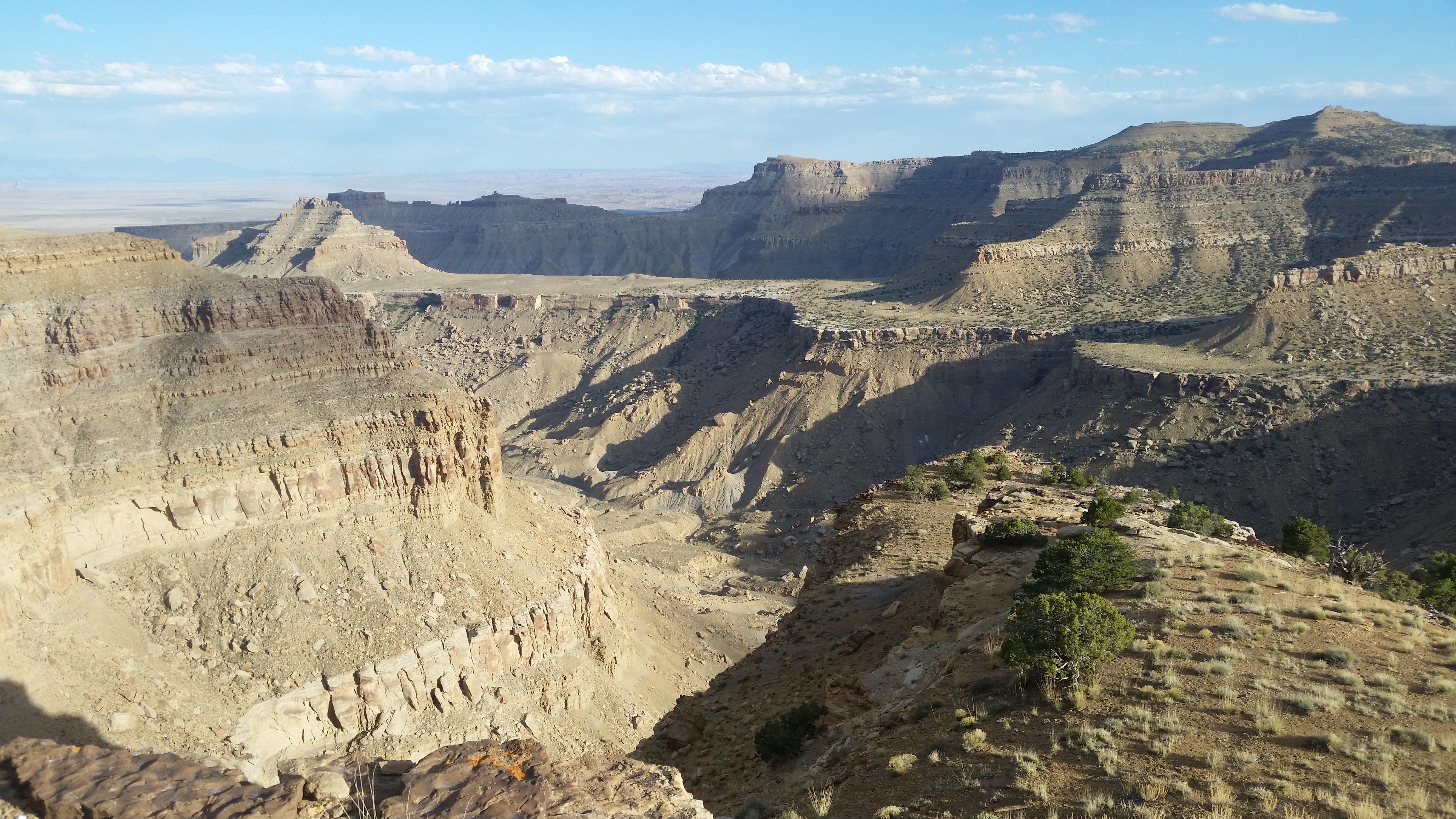
- Middle Mountain el 7022 is NW of Green River. It's too long a hike for one day. An ancient stock trail climbs out of Blue Castle Canyon to el 5300. It tops out on the rim a half mile west of Blue Castle Butte where the rim turns north then it's a rim walk to the upper part of the canyon for basecamp. It took me 3 hours from the parking spot on the north side of Blue Castle. The 700 gain up the trail is the only strain. The west side river road is paved to N39 05107, W110 08834 where a 4wd goes left for about 2 miles and drops into the wash on the north side of Blue Castle. I was able to ride my 125 a short way up the wash then walked it until I was reading 450 feet from the trail which starts at 05525, 12827 el 4700. A gully there with cairns leads 450 feet to the trail. It goes up and bends left then back right up to 05355, 12898 el 5050 then to 05331, 12990 el 5200 where it goes up to the base of the rim cliffs then right along that to the top at 05332, 13106 el 5300. A million cairns are there now so GPS shouldn't be needed once on the trail. I strolled up the rim to the upper part of the canyon where " canyon " appears on the topo. That's where the cottonwoods and seasonal water are. The class 2 drop in point is at 06138, 14986 el 5650. A tenth mile past that on the rim is a drainage with a bunch of potholes with water. I dropped to the creekbed and started to panic when I saw it bone dry as opposed to intermittent flow on May 12, 2023 ( I found the rim potholes the next day ). I went up canyon and wet sand cheered me up then I came to a puddle shaded by a flat rock. Not much but it bailed me out. 10 minutes or so up canyon is a dry fall with pools of water on top. A sheep trail goes up around the right to it. Then comes a slot that is blocked. MIDDLE MOUNTAIN - for that, climb a slope up to the east rim but the final climb is a 15 foot class 3 crack which tops out at 06228, 15107 el 5650. It's easier going down than up. Then stroll down nearly a mile downstream to a canyon and go up the creekbed until 200 feet from 06560, 13877 then go up to it and level off to get into the right fork. Then go up a slope to a stairway at 06480, 13798 el 5900 that leads to the top of the ridge then it's obvious up that to the rim at 06782, 13691 el 6400. Some old cans are there. It's a good pj forest on to the summit at 08704, 16134 that had nothing, not even a cairn. Along the way were more cans at 07668, 15526 then at 08016, 15588 is a survey marker dated 1930. That took 7 hours with 1000 strenuous gain. UPPER CANYON - to get to the end of the canyon from basecamp at the cottonwoods, walk either rim though the east one is shorter. Before the first fall, go left up a ridge with cairns at 07028, 15358 then bend right to 07064, 15434. Go up a little more to a shelf then level off to the top of the fall. The next fall has an obvious route around the left then it's a stroll to the main rim el 6317 where I stopped but later figured out that sheep herders must have had a route on up the rim. Peak 6572 looked climbable. That's a 2 or 3 hour hike with 400 strenuous gain. It's best to do this over 3 days, 2 nights. I did it in 2 days and one night but had 10 hours of hiking one of the days. And going in late April reduces the chances of water issues. Every storm will leave behind thousands of potholes with water. Posted May 18, 2024. UPDATE - in 2025 I rode my 125 to the TH then hiked the route to the top of Middle Mtn and on to the spring on the topo just below 6400. It had a tiny flow under an overhang and a camera set up. A trail had been built down to it. A log fence is nearby. I went on up the rim to find the stock trail out of Blue Castle Canyon but only found cairns. I went down with 2 minor class 3 drops then walked the canyon back out. I would prefer this loop clockwise. Take the route to the upper canyon then get on the last segment of the trail that I could find which is at 07548, 15684. That ends soon then go up to 07663, 15569 and angle up to the right to the first class 3 at 07656, 15538 then up to the rim at 07672, 15536 with a 4 foot step. Then down the other route at the 6400 line after side trips to the summit and or the spring. I put a track on peakbagger 2025. I did it in 10 and a half hours but way better to have a basecamp at the cottonwoods. Ebikes can make it to the TH.
