Search This Blog

Monday, June 3, 2019

Stillwater Range

Job Peak as seen from the south 

  • The west side road (WSR) starts out east of Fallon as highway 116. Pavement lasts for 12 miles then it's a wide, rarely graded road and goes nearly 50 miles to pavement again at N40 03617, W118 11223 where it swings west around the Buena Vista Hills. Then it's another 6 miles to a fork. Left goes paved for 13 miles to I-80 at exit 112. Right is paved for nearly 9 miles then it's a super graded road for about 24 miles to McKinney Pass. I started on highway 116 and towed a camp trailer for 40 miles as far as Fondaway Canyon and had a Verizon signal, but then damage from May floods was making it too slow. I made a U-turn and came back in at exit 112 on I-80. Fallon has a Walmart at the west end. Lovelock has a Safeway and Family Dollar. Posted 2019.
  • TABLE MOUNTAIN el 8312 has a jeep road to el 6000 in West Lee Canyon. Turn off the WSR at N39 36248, W118 22048 and stay right at forks for about 3 miles to a gate el 4700. Stay left at the next fork and soon there is a bad hill el 4800. Jeeps have no trouble with that then it gets easier to a flat area el 5800. It's not worth going beyond there. I walked on up the road from there and it shrinks to a steep OHV track that ends at a stream el 6500. I climbed up the left slope on a trail reading 33807, 18461 el 6500 and got on the ridge and followed it up to 33459, 18173 el 7150 where a trail skirts along the east side of peak 7318. I kept going on cow trails past some small trees at 33180, 18147 el 7300 then up to a constructed trail at 33009, 18337 el 7550 then picked it up again at 32971, 18409 el 7650. It takes an easy angle up to the plateau el 7850 then it's less than a mile to the summit at 32483, 17939 where a can had no book. It needs a jar too. 4 and a half hours, 2500 gain and hardly any is steep. The canyon had a good flow and a camp area with some shade at the bad hill el 4800. Posted 2019.
  • MOUNT LINCOLN el 8569 has an easy route out of Pete Canyon on pleasant ridges. A loop can be done to Job Peak. Turn off the WSR at N39 36248, W118 22048 and stay left at forks until a creekbed crossing at 35562, 17073 el 5234. Use the road on the east bank of the creekbed and it's good for a mile then it dips into the creekbed at el 5800 and is chewed up for a tenth mile. Jeeps can get thru and in less than half a mile is a main fork el 6034 in the canyon. OHVs can go left up Middle Fork to el 6800. I took the right fork into South Fork, which is good but has a sharp dip, and parked at the end el 6300 in nearly half a mile. I walked up canyon on cow trails then up the smooth east rim at 34161, 15419 el 6600 and on up to the crest. An antelope came down to el 7800 to greet me. A faint trail runs on the crest. At a third mile before the peak, it swings east around a steep section then goes up and crosses back to the west side about a tenth mile north of the summit. The reg is at 32964, 15783. I then walked north on the crest and the trail faded away on the east side of peak 8089 but it's not needed to go on to Job. I descended off the crest at 34451, 14617 next to peak 8121 and followed the main ridge down. Just doing Lincoln would be a 4 hour hike with a little over 2300 gain. With Job it comes to 6 hours and the last 700 feet up that peak goes parabolic. It would add nearly a mile each way if starting where the road goes bad at el 5800. There was a lot of water running in this canyon. The trail was likely a CCC project, but I couldn't see it south of Lincoln. Posted 2019.
  • JOB PEAK el 8700 is the high point of the Stillwater Range. A man made trail along the crest can be used from the north. It is visible on google earth. There is an upper TH and a lower TH, I only used the upper. Turn off the WSR  onto the Poco Canyon road reading N39 38400, W118 20893. Go up that easy 4wd road and keep right at forks for nearly 6 miles until you reach a fork way up canyon reading 36653, 15659 el 5650 (the best shady camp is a third mile before the fork). Left goes to the upper TH, right goes to the lower. Look straight up the right fork then up to the high crags. Right below the crags the trail can be seen going up and left. Drive the right fork for a mile on easy 4wd to the last camp spot at a corral. Then go another tenth mile to the end el 6400. Walk across a gully to a juniper at 36468, 14572. The trail is right behind it. It goes up and starts switching. One faint switch is at 36616, 14527 el 6700 where it goes left and straight over to the main ridge el 6800 where it is visible from the road below. I stopped here and was less than half a mile from the upper TH.  Now the upper TH road is bad and is now for OHVs only. Right away is a steep hill with a narrow bypass on the left. After that there are eroded sections, but no big obstacles.  The road ends at a good camp spot el 7300 next to a fence. The trail starts up to the left of a crag and is hard to see at first, but it crosses the fence at 36774, 14111. Or just walk over to the fence then go up along it to the trail. The trail goes along the east side of the crest and crosses a saddle el 7500. Two trails can be seen across the saddle, take the high one switching up. The trail will get faint at el 7900 where it goes left around a crag. It stays at the 7900 level until you need to leave it and climb a little to a viewpoint at 35690, 13819 el 8050. Now you can see the rest of the route. Just keep walking on the easy ground on  the east side below the crest, and gradually gaining. Stay on the east side. The reg is at 34983, 14128. The last 300 feet is the only steep part, and game trails zigzag up that. 4 hours, 1500 gain from the upper TH. A top notch hike. These trails need to be adopted by someone. Are there any hikers in this part of the state? BIG BOX CANYON - this is easy to get at for anyone with the means to get on the crest road. On the crest about a half mile north of the upper Job Peak TH there is a road going SE into the canyon. The reading there is 37198, 14082 el 7050. In half a mile there is a cabin where the creek rises out of the ground. The cabin is intact but messy. The road ends a fifth mile past the cabin where I could see a good viewpoint on the north rim 3/4 mile away. I walked to that and could see a grassy slope into the gorge. I went down to the creek and shortly came to the main fall. I stayed high on bedrock on the right and found an easy gully down to falls in a side canyon then it was a short walk to the base of the main fall. I took a chance and climbed a wide ledge up along that fall. It starts out tricky but then it's class 2 to the top end where it narrows down to one foot wide. It took a couple of steps to get past that but it has good holds. That shortcut paid off big time and is worth it even if you fall and die. I followed the creek back to the start. That took 3 hours with 1000 feet of gain, mostly not steep. There is some light brush. Backpackers could use the lower TH in Poco Canyon to get in, but there are no shade trees around the cabin. 4wds have been driving in on a crest road from the Job Canyons, but there are ultra steep grades on the crest and some flood damage in West Job but I didn't check East Job. Posted 2019.
  • LAMBING PEAK el 7200+ is what I call the peak at the head of Lambing Canyon. A 4wd road going over the crest to the south makes it easy, when passable. Turn off the WSR onto the Poco Canyon road reading N39 38400, W118 20893. Go up that good road and keep right at forks for nearly 2 miles then go left at a main fork that goes into West Job Canyon. At el 5500 the road forks. The fork that goes up the south rim was chewed up by recent floods and I couldn't get traction, but a 4 wheeler might make it. I expect that popular road to get fixed, but meanwhile a 3 hour loop hike can be done. Keep driving in the canyon bottom for another .4 mile to a sunny camp with a stream el 5700. Walk along the stream then go up the north rim next to a lone cottonwood at 38700, 15144 el 5950. Keep going up to 39038, 14669 el 6850 where a saddle el 6800 on the crest is in view. Cut over to it then go up a steep jeep road almost to where it tops out then angle around to the right to a saddle at 39323, 14265 el 7000. Then it's easy to the reg at 39676, 14412 placed by the Henneys a month earlier. They beat the floods. Walk back on the road on the south and drop down to the start. 3 hours, 1100 noticeable gain. These are pleasant ridges. A few cows grazed here years ago and horses haven't found it yet. An OHV trail runs south on the crest then down Poco Canyon. Posted 2019.
  • SILVER HILL el 7300+ has an OHV trail to el 5450 on the west ridge. Turn off the WSR at N39 41675, W118 18708 and drive into Cox Canyon then take the first left that's still in use, not the one on the topo. That's gone. Drive to a fork at 41628, 16479 el 4800. I wouldn't take a 4wd past there but OHVs can take the left fork up to a saddle el 5450. It's a pleasant ridge from there to a saddle at 42200, 15175 el 6750 then a plush pj forest to another saddle at 42247,14738 el 7100. It's another quarter mile to the reg. Placed in 1993, the Henneys signed it in 2019 and that's it. That's a long drought, but likely because it's only a hill. That took me 3 hours with 1900 gain.  4wds will have an extra hour of hiking. A decent road goes on up Cox Canyon past rock cabin ruins to el 5600 with pinyons and a stream. Horses haven't found it yet. Posted 2019.
  • COX BENCHMARK el 4453 is the tiniest peak in the range. Turn off the WSR at N39 44615, W118 16895 and go half a mile then turn right on an eroded road that goes to the peak. It's 5 minutes and 100 feet to the top. Posted 2019.
  • MILL CANYON has a high clearance road to the mouth where there is a stream and cabin. Turn off the WSR at N39 45550, W118 16302. Horses have decimated the area. Posted 2019.
  • HOT BENCHMARK el 7578 has a jeep road to el 6100 on the NW ridge. Turn off the WSR at N39 47225, W118 15418 and there's just one road to follow. At 46704, 13868 el 5100 some rocks have slid into the road but one man can move them. The road ends at the Shady BM then it's a nice pj forest up the ridge to a minor saddle at 45573, 12657 el 7400. The reg is another tenth mile beyond that in a plastic jar that won't last. 2 and a half hours, 1500 gain. The jeep road has little erosion but that won't last. Shady Run Canyon would be another way to climb this peak. Posted 2019.
  • SHADY RUN CANYON has a stream and cottonwoods and has largely recovered from horses. Turn off the WSR at N39 47717, W118 15113 and drive on easy 4wd to the end at the mouth. A faint trail runs up the canyon. The trees end in a third mile and I was able to easily walk to the 5000 level where I could see it getting easier to climb up to the rim and go on to Hot BM. That would be a good hike if horses don't return. Posted 2019.
  • FONDAWAY PEAK el 7444 is what I call the peak on the north side of Fondaway Canyon. A jeep road goes to el 5700 at the SE ridge. Turn off the WSR at N39 48487, W118 14702 and drive up into the canyon for about 4 miles to where it opens up then stay left at forks to the end. The route is obvious until el 6600 where there are 2 choices. I went up the wide gully ahead but had to traverse a risky slope. It's better to stay left to 48700, 10816 el 6650 then go up to the main ridge. Then walk level along the west side to a gully at 48833, 10833 and go up and the rest is obvious to the summit at 49093, 10687. 3 hours, 1800 gain. This is one of the better looking peaks. Rigs wider than a jeep might have trouble on these roads. Posted 2019.
  • SHAMROCK PEAK el 6537 is what I call the rugged peak on the south rim of Shamrock Canyon. Turn off the WSR at N39 50066, W118 14479 and go a mile on 4wd to where the road goes bad el 4150. Walk to the ridge straight ahead and go up to el 5800 then stay left around boulders then get right back on top and go up to a sheep trail on the right at 49624, 11918 el 6150. Go on up into the crags and there are pathways thru with a couple of class 3 spots to get to the summit at 49530, 11932. 3 and a half hours, 2400 gain. The ridge has no hidden dips. Sheep tracks cover this route. Posted 2019.
  • WHITE CLOUD CANYON has a major stream and a miner trail. Turn off the WSR at N39 51181, W118 14231 and drive to the mouth el 4300 on easy 4wd then hike up the south rim to 50860, 12890 el 4500 where the trail first show up. It runs along the slope to 50918, 12628 el 4600 where it starts dropping down to the creek about a half mile from the mouth. I was able to go upstream a quarter mile then it got too brushy. There is some light brush and shallow wading. This trail needs someone to adopt it. Are there any hikers in this part of the state? Posted 2019.
  • CLOUD BENCHMARK el 7512 has a smooth ATV trail to a saddle el 5450 on the north rim of White Cloud Canyon. Turn off the WSR at N39 52876, W118 13710 and go about 2 miles on easy 4wd to a fork at 52151, 11952 el 4500 where 4wds are stopped. ATVs and cycles can go up the right fork thru a short patch of tamarisk then take the next right fork and the road can be seen climbing up. It tops out on the rim which is where I started hiking. Peak 5950 is in the way right out of the gate. It's best to go nearly to the top then cut around the right side and shave off 50 feet or so to get to the saddle el 5800 behind it. The next bump on the ridge is peak 6558 and I had to go over that one. Next comes a good game trail at 51416, 09605 el 6600 which skirts along the right side of peak 6664 and into a saddle behind it. Cattle trails run from there all the way to the summit at 50472, 09369. I wasn't expecting that. Next, I dropped down to the west ridge at 50530, 09546 el 7100 and walked low along the right side to get past fallen trees then got on top and on to 50628, 09949 el 6850. From that point any ridge would work. I went down steep dirt then moved left to a ridge at 50587, 10015 el 6700 and easily went down that to 50449, 10403 el 6100 where I turned NW to get to the bottom. I followed an intermittent stream down the canyon to the road that goes back up to the start. First I went downstream for half a mile to cottonwoods and a collapsed building. Water was flowing out of a tunnel just past that. I returned to the road but should have gone up a drainage at 51149, 11241 to get to the rim. That took 6 hours with a little over 2000 gain to the peak then another 400 to climb out of the canyon. It would be about 5 hours if I had returned the same way. Hikers with only 4wd rigs would have an extra 1000 gain and likely a 7 hour hike. It's easy terrain. Posted 2019.
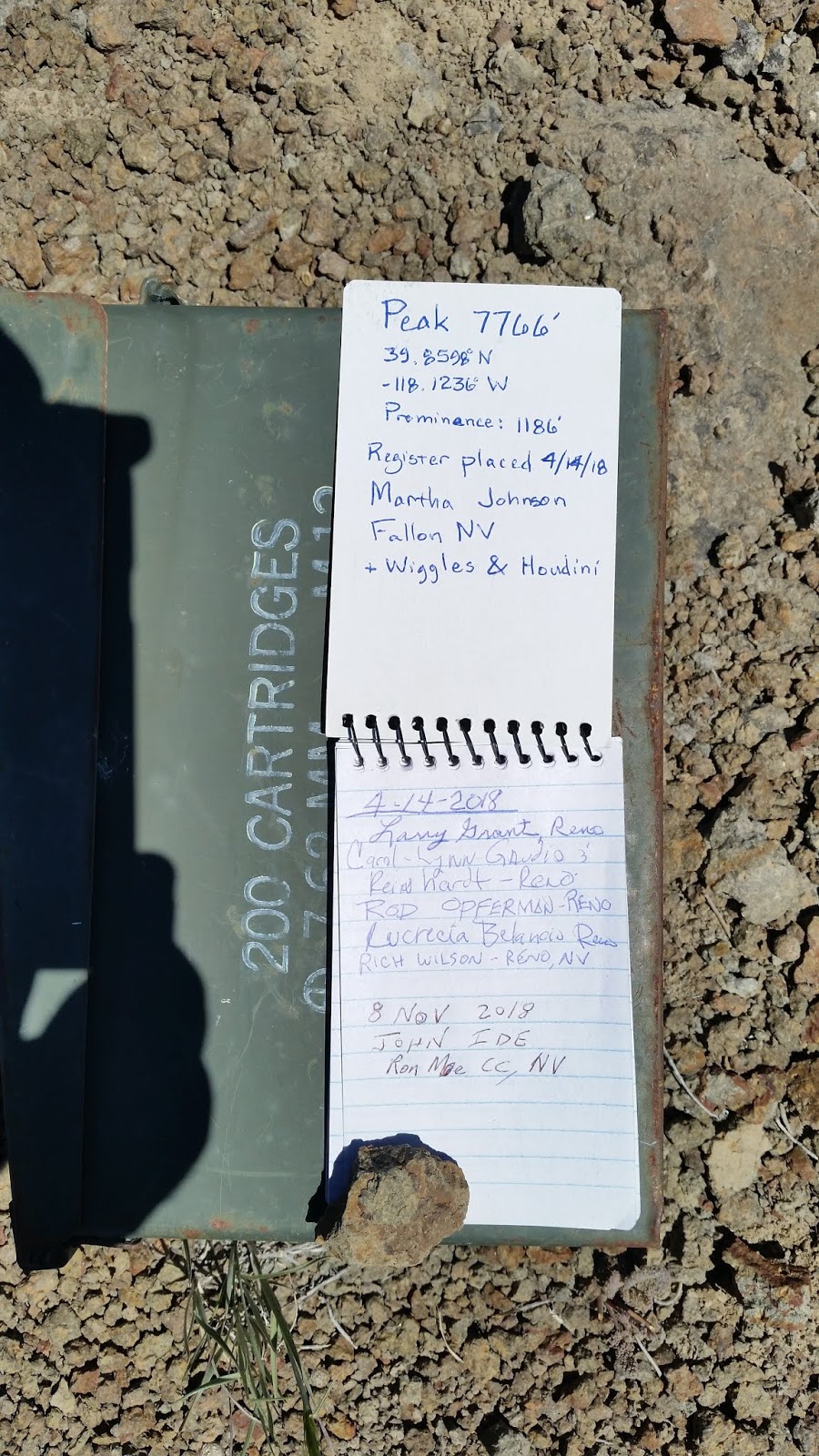
  • EAGLE SPRINGS PEAK el 7766 is what I call the one high on the east rim of Mississippi Canyon. Jeeps can make it up Copper Kettle Canyon to el 5100, OHVs make it to 6100. Turn off the WSR at a silly gate reading N39 58092, W118 12252 and go a bit over a mile to a 4-way. Turn south for 3 miles to a fork at a crossing. Go right to 54065, 07676 el 5100 which is as far as I would take a jeep then I would hike the north ridge. A rocky stretch along the jeep road only lasts a fifth mile. OHVs can keep going a bit more to a sign for the Steam Shovel OHV Trail. It shows on the topo as a pack trail. Follow it to el 6100 then start hiking the easy NE ridge at 53652, 05765 el 6100. A useful cow trail at 53099, 06258 el 6800 dodges a lot of fallen trees. The next useful trail is at 52809, 06753 el 7100 and it skirts the left side of peak 7217. Then go on to 52155, 07122 el 7400 to skirt the left side of peak 7448 then on to the summit at 51592, 07409. An ammo can had been placed a year earlier by a Reno party. That took 4 hours with nearly 2000 gain, all easy. It's a nice forest but pristine it ain't. Remnants of a crest trail can be seen along this hike that likely went as far as Cloud BM. EAGLE BENCHMARK el 7615 - keep going on the OHV trail and park a third mile before the peak. It's 500 gain to the summit at 51850, 03959 with dramatic views sitting 4000+ feet above the valley floor. There was easy access to this peak until the Anderson Ranch blocked the main road in from the north. A fortune was spent building that road. But I could see on the sat image that an OHV trail connects from the main road to White Rock Canyon. Then there's a way out to Kitten Springs because I rode in that way earlier. Hikers don't have OHVs but the east ridge from Dixie Valley looks feasible as an alternate. Posted 2019.
  • TABLE MOUNTAIN el 7700+ is the second such named peak in the range. A long, easy hike can be done from the Kitten Springs Rd. Turn off the WSR at N40 06542, W117 58631 and go 6 miles on easy 4wd to Kitten Springs Canyon where a stream is crossing the road. The grave of Alexander Brown is on the right. Keep going a mile and a half to a hairpin turn el 6100 then hike up into a saddle at 02482, 55878 el 6400. Go up the ridge to el 7000 then bend left to a cow trail at 02000, 56877 el 7100. Walk that then veer off to the north rim at 01530, 57049 el 7200 which is where the best part starts. Stroll along the rim taking in the views until a steep 150 foot drop at el 7350. Ranchers built a trail down that then it runs on the north side of a fence and at 00575, 59303 el 7250 it angles down to the SE saddle el 7050 of Cornish Peak. That's the easiest way to do that peak. There is a spring a tenth mile down that trail. Keep going to the county line marker at 00143, 59885 el 7600 which is just a wooden stake. They're cheap. It's another mile to the high point. That took me 7 and a half hours and the 1000 moderate gain to get on the plateau was the only part that wasn't easy. The side trip to Cornish took an extra 90 minutes and requires long pants. The survey pole at the Stillwater benchmark was still standing from 1953. Cattle graze at the head of Cottonwood Canyon but impact is light elsewhere. Horses haven't found this yet. Posted 2019.
  • BOLIVIA is a mine site SE of Table Mtn.  Turn off the WSR at N40 06542, W117 58631 and go 6 miles on easy 4wd to Kitten Springs Canyon. Keep going over a divide and down to a T at Cottonwood Creek el 5000, a large stream. Left goes a mile down the creek to shady camps then the road is harder to the end in a little over a mile. Buildings along there have collapsed. Back at the T, the other road goes up along the creek then peels away and after about 3 miles from the T is a fork el 5900. Left ends soon at mines, the right fork is a jeep road that drops down a burn area to Bell Mare Canyon, which had a good small stream, then goes up to the crest and exits the burn area then tops out at el 7150 next to peak 7228. It's a short hike to Table Mtn high point and to Cotton Benchmark at N39 58446, W118 01950 el 7823. Along the way on the crest is a possible Indian rock ring at N39 58693, W118 01716 el 7500.  Jeeps make it to peak 7228 but beyond there are a few short sections of ruts that are tricky for all 4 wheelers. The road goes on to the White Rock Canyon watershed then over the crest to the Anderson Ranch, but they have blocked it there. Posted 2019.
  •  GAMBLE PEAK el 7651 is what I call the next major peak NE of Table Mtn. A good road goes to el 6000 on the north ridge. Turn off the WSR at N40 09109, W117 55773 and go 7 and a half miles to a main fork. Go left for a mile then go south on a crude road for a quarter mile to the end el 6100 on the north ridge. Go up the center of the ridge over point 7163 then into a saddle el 7050 and on up to the summit at 02939, 50343. It's a third mile from there to the north end where I found what I was looking for, an Indian rock ring at 03160, 50142. Another is at 03136, 50203. That took 3 hours with 1800 gain. Some is steep but zigzagable. It's the best forest I saw in the range. FENCEMAKER el 7283 - stay on the main road another 3 miles to the towers then go past them another quarter mile to a shady tent site el 6800. Just walk on the center of the crest to 06612, 49843 el 7100 then to 07021, 49753 el 7000 then to the peak at 07438, 49947. It doesn't pay to skirt the bumps on the crest because they're too long with too many fallen trees. That took 3 and a half hours with hardly anything steep. Posted 2019.
  • GRANITE BENCHMARK el 8419, the high point of the East Range, is the first major peak north of the Stillwater Range. A loop can be done using the rims of Ladd Canyon. GPS tracks are posted on peakbagger.com for the west rim part of the loop. Turn off the WSR at N40 13001, W117 49731 and take a bad road to the mouth, staying left at a fork along the way. There are two ways to start out. One is to go up a DIY road on the west rim which soon fizzles then just keep going up. The other is to walk the OHV trail in the canyon for a mile and a half then go up an easy ridge at 15665, 48865 el 6400 and top out on the west rim at a saddle el 6850. It's obvious how to go up the ridge then bend left to the reg at 16818, 49025. Then walk east on Cinnabar Ridge for a mile and a quarter to Granite Peak el 8330. A plane crash is along the way at 16832, 48344 el 8150. It missed clearing the crest by 30 feet, if that's what it was trying to do. From Granite Peak, it's obvious how to walk the east rim down and then either drop in near the exit point or keep walking the rim to the mouth. I was able to ride a cycle a mile and a half up the canyon and then had a 4 and a half hour hike with about 2500 gain, none of it very steep. The OHV trail is overgrowing and is the only part that needs long pants. There's a good stream in the canyon with no recent cattle. Posted 2019.

    Indian rock ring on Gamble Peak

    Eagle Springs Peak. Somebody lugged an ammo box up there.
    Fat lizard smoking a cigar.
    Creek in Pete Canyon and the easy ridge to the crest.

    Falls in Big Box Canyon

    Table Mtn at the north end of the range.

Monday, May 20, 2019

Reveille Range

Flat Top and then Reveille Peak in the distance.


  • The best part of this range is the east side and it just so happens that highway 375 runs along it. Every 8000+ peak comes with a pj forest as standard equipment that's easy to walk thru. The lower elevations have thin sagebrush, also easy to walk. Horses are making a mess around Hyde Spring but not south of that, yet. Gas for this area is at Lund, Tonopah and Ash Springs. A Verizon tower is on the peak above Warm Springs. This turned out to be the best 8000 class range I've been in. Posted 2019.

    • GOBLIN KNOBS - a smooth road goes into this area. Turn off highway 375 at mp NY 15.2 and drive along the shore of Echo Canyon Reservoir and keep going nearly 5 miles to a fork. Right ends in a third mile on top of a steep hill el 6600 and would make for the easiest hike to Dark BM. The left fork goes 1.8 miles to a T and has a couple of steep but short downhill sections. Going left at the T goes back to 375 at mp 18.8, going right leads to Hyde Spring and the road over the pass at Lost Burro Mine. Posted 2019.
    • HUMP BENCHMARK el 5841 is next to the highway. Park at mp NY 17.5 next to a gravel pit el 5000 then go up the easy ridge there to the BM at N38 07666, W116 06180. It's easiest to walk north from the pit into a canyon then get on the ridge. A million sheep beds are on the ridge and a small research balloon is at 07708, 05695. It had a vacuum tube. I hadn't seen one of those in decades. A herd of sheep walked up when I was at the summit. That takes 90 minutes with 800 gain. Posted 2019.
    • HYDE PEAK el 6674 is what I call the easy one east of Hyde Spring. Turn off highway 375 at mp NY 22 and go about 4.2 miles on easy 4wd to a main fork. Go right for a mile almost to the spring then hike up to a break in a cliff at N38 03589, W116 08378 el 6050. Walk on up the easy ridge to rough bedrock where an obvious pathway angles up to the right. When that ends, go up along the right side of a dark cliff then get on top of it then it's smooth walking to the summit at 03991, 07658. 90 minutes, 900 gain. This is too easy to pass up. The spring had a decent flow out of a pipe. ALTERNATE : drive in from mp 18.8 for 3 miles on easy 4wd then start up the easy north ridge at 05783, 07824 el 5600. This takes twice as long but still easy. DARK BENCHMARK el 7416 is another easy one. Keep driving NW past the spring for a mile and a quarter to a main fork. Go right and stay on the main road down to a wash at the base of the peak. Go left along the wash on a faint road and pick a route up. I went up the wash until I could see an easy route up to the west ridge then went up to it at 06503, 11101 el 6700 and on to the summit at 06856, 10537. 2 and a half hours, 1400 gain. The main road goes directly down to the highway at mp 18.8 and so would be an alternate approach. Use the Goblin Knobs road for the easiest hike up this peak if you're super lazy. Posted 2019.
    • STREUBEN KNOB el 7532 sits north of the main road over the crest. Turn off highway 375 at mp NY 22 and follow the main road for 5 miles to a fork at N38 02711, W116 09143 el 5900. Left goes to Reveille, but go right up a wash thru a narrows for a quarter mile to another fork. Left goes to the Gila Mine, but go right heading toward the pass            to  02918,  12008 and follow a faint road for half a mile to the end at 2 very old mine shafts el 6550. I aborted the hike due to a storm, but it looked easy. The main road tops out on the crest where juniper provide some shade. This is all easy 4wd. Posted 2019.
    • LOST BURRO PEAK el 7554 has a lot of mine relics. I went north from Reveille on a road for nearly a mile to the mouth of the next canyon where the road is washed out el 6400. I walked on up canyon for half a mile to the Gila Mine at a fork in the canyon. The road goes up the left fork then over a low rim and back to the main fork where there is a log cabin. The road goes on up to the main saddle el 7000 at the end of the canyon. It goes north up from the saddle for a short way then ends at el 7150. I kept going up and saw mines to the left in a drainage. A dugout cabin is there at the mines. I went up the drainage to the end at a saddle el 7400 where the rest was in view. The summit is at 02765, 11229. I retraced back to the main saddle el 7000 then walked a road south from there spiraling up to peak 7443 then down to another road at 01720, 11492 el 7200 that took me back to the start. 3 and a half hours, 1600 gain. I used the road running NE from the mouth to get back down to the highway. Posted 2019.
    • PEAK 8000+ is the northernmost 8000 footer in the range. Turn off highway 375 at mp NY 22 and follow a 4wd road staying left at forks and it goes thru Reveille then over a saddle to a fork at N38 00953, W116 10278 el 6950. Go left down into a canyon for a mile or so then start walking up a wash at N38 00417, W116 09389 el 6500. Follow it over a divide el 6650 then on to a canyon at N37 59707, W116 09406 el 6700. Go down that for 2/3 air mile then go up the fork that runs under the peak and pick a route up. I went up at N37 58309, W116 10074 el 7150 where it goes parabolic and topped out at N37 58137, W116 10147 el 7750 on the NW ridge then turned left for an easy stroll to the summit. 4 and a half hours and all easy except for the 700 gain up the NW ridge. A lot of good pj forest here. It might be worth it to go around and climb the SW ridge and come down off the NW ridge. There is also an unmapped road coming in from the west but wouldn't be worth it for one peak. The spring at Reveille had a fast drip and shady camps start just past it.  PEAK 7911 is an easy one nearby. At the fork el 6950, take the other road for a mile to where it turns bad el 7300. Jeeps might still go on, but I walked on up the road in the canyon to the crest then followed it left toward the peak. For the last bit I climbed right of center to the summit. That took an hour with 600 gain. Posted 2019.
    • BLOW BENCHMARK el 6584 is north of the  spring and routes are obvious. I went to the SW saddle then up to the high point at N37 57125, W116 06609 el 6617 where there is a witness BM . The main BM is .31 mile to the east. I came down a steep slope in the middle. 2 and a half hours, 1100 gain. Posted 2019.
    • FLAT TOP el 8101 has routes up the east, north and west, the latter being the easiest.  This turned out to be the best hike in the range. Turn off highway 375 at mp NY 30.3 and go 4 miles on easy 4wd to Pyramid Spring el 5800 and go right at a fork for a quarter mile to a saddle el 5900 at Fang Ridge. Don't try to drive past there and make a big eyesore. Walk to a wash at N37 56298, W116 07505 el 6000 and go up it for half an air mile into a forest then climb out on the right along a gully to a saddle el 6250 where the peak is in view. I went up the obvious steep east gully, but could see from the summit an easier gully on the west side. For that, get in a wash at 56146, 09002  el 6800 and follow it west up to the south saddle el 7300 then go around to the west saddle at 56451, 09963 el 7800 where the route up should be in view. That route should work. If not, every hike comes with a money back guarantee. Just send in the unused portion. I made a loop by going on north to peak 8300. On the north rim of Flat Top, I descended an easy class 3 chute at 56573, 09845 el 8050 and in less than 200 feet I was thru the cliffs and could move left to get to the north saddle el 7700. Then I walked right of center past crags until forced to left of center and stayed there until 57065, 09692 el 8000 where I could go straight up to the summit ridge. It was an easy walk on to the twin summit blocks at 57152, 09821. Then I walked back SE on the summit ridge for a quarter mile to the main saddle el 8000 and turned NE to another saddle with an Indian rock ring at 57108, 09383 el 7800. I soon found out where they got their water because I descended south down the canyon and came to a stream. It goes over a 30 foot fall but there is a gully on the right that drops down to the base. Another bypass is a drainage on the left that has small caves with burnt wood. Then there is one more smaller fall and after that it opened up and I cut over to the rim at 56801, 07855 el 6250 where I could see the start. That took me 7 hours, 15 minutes and would be about the same had I gone up the west gully of Flat Top, which is what I do from now on. Strenous gain would be less than 1000 feet. This is a May hike when water is running. Pyramid Spring had a decent flow out of the ground but might be from a leaky pipe underground. Cattle had not polluted it, but that can change. The main road ends a half mile past the spring with some shady tent sites el 6000. Posted May, 2019. SHORT VERSION - the peaks can be skipped for a shorter loop to the falls. Follow the hike above as far as the saddle el 6250 then aim for a wash at 56446, 08736 el 6700 and follow that as it bends to the right then go up a fork at 56496, 09241 el 6900 and then up to the main saddle at 56726, 09201 el 7200. Peak 7393 is an easy tenth mile to the south with a good view. A long row of cairns on top may have been placed by Indians. Do not disturb. From the saddle, go east down canyon and merge back with the route above and on down to the falls. That took 3 and a half hours with about 500 gain that could be considered strenous. Posted May, 2019.
    • PEAK 8135 has an easy east ridge. A good loop can be done. Turn off highway 375 at mp NY 30.3 and go 4 miles on easy 4wd to Pyramid Spring el 5800 and park. Walk south to the next wash then go SE down that for a mile to the flats el 5500 then go south a mile to the east ridge and pick a route up. I went up at N37 54581, W116 06191 el 5750 to get on the point then it was a cakewalk to the summit at 54492, 08761. Then I dropped off the south side of the summit and circled under the west side of it to get into the north canyon at 54613, 08856 el 7650 and followed that down. I turned into a left fork at 55100, 07789 el 6300 and went up that toward crags and over a saddle el 6400 then down the left side of the drainage on the other side. Then it was a stroll back to the start. That took 5 hours, 12 minutes with about 2700 gain, none of it very steep. I'd rate this as the second best hike in the range. BLOW BENCHMARK el 6584 is north of the  spring and routes are obvious. I went to the SW saddle then up to the high point at N37 57125, W116 06609 el 6617 where there is a witness BM . The main BM is .31 mile to the east. I came down a steep slope in the middle. 2 and a half hours, 1100 gain. Posted 2019.
    • PEAK 8265 is a triple summit. I went up the north canyon from near Pyramid Well then over the highest summit and down the east ridge. That's only a 5 or 6 hour hike with easy walking in a good forest. Posted 2019.
    • BLACK TOP BENCHMARK el 6972 is a colorful one on the east side of highway 375. Turn off at mp NY 42.1 and go 3.7 miles on easy 4wd then walk nearly a mile along the east side to the SE saddle el 6350 then go up the ridge to the summit block at N37 47153, W115 55982. The west side of the block is the easiest route. I retraced 400 feet to a white saddle then went straight down. 90 minutes, 700 noticeable gain. The flat top el 7087 to the south is the highest peak around. Turn off at mp 45.7 and stay left at forks on easy 4wd for a mile then go right for a tenth mile to the end el 6250. Walk low along the west side of the SW ridge to 46085, 56350 el 6550 the go straight up to the ridge top then follow a steep sheep trail to the summit where there is a reg and DOD BM from 1985 when there were plans for missile sites in the area. 90 minutes, 800 gain. These peaks are interesting. Posted 2019.
    • REVEILLE PEAK el 8812 is the high point of the range. The north slope offers the unsteepest route. Turn off highway 375 at mp NY 43.5 and go a bit over 8 miles on a paved road to a deserted ranch. Turn NW on a graded road and go 8 miles to Willow Witch Well. Turn toward the peak and go 3 and a half miles on easy 4wd to the end el 7100 with room to camp and some shade. The road is mtn bikeable. Walk NE into the main canyon then at el 7600 the north slope comes into view. I zigzagged up to N37 51393, W116 08327 el 8000 then directly up to 51355, 08363 el 8200 where I was on a ridge and soon merged with the main NW ridge then went on to the reg at 51220, 08149. My name was in it from 1996 but I couldn't recall the hike or the drive. I descended the steep direct route that most hikers come up. 3 hours, 1700 gain, 200 of it is steep. The well is at 50448, 12654 el 5900, the end of the road is at 51274, 09200 el 7100. Posted 2019.
      Peek-a-boo. A herd of sheep spying on me at Hump BM.
      Cabin near the Gila Mine

      The east ridge of Peak 8135 and Fang Ridge

      Indian ring near Flat Top
      Residents at Pyramid Spring

    Golden Gate Range

    Indian ring on the highest peak in the range.


  • This range is in the Basin and Range National Monument.  Gas for this area is at Lund, Tonopah and Ash Springs. I used good dirt roads running south to north for nearly 80 miles that I call the Golden Gate route (GGR) for reference. It starts at mp LN 4.1 on highway 375 a few miles NW of Rachel. In a dozen miles there is a deserted ranch where I followed the main road as it bends to the right. At about mile 15 is a main fork, I went left there then right at the next main fork and the road goes to the northern tip of the Worthington Mtns at a main fork reading N37 59321, W115 35397, which is a fifth mile past where the Mail Summit Rd merges in. I took the right fork for 3 miles to a cattleguard then went right on a road that bends to Water Gap by way of Put Back Spring. I turned west thru the gap and crossed a bridge there over Cherry Creek (the Golden Gate bridge, of course) and took the next road forking to the right that runs along the east side of the range for 7 and a half miles to a tricky fork at N38 07676, W115 18479 el 5054. I took the right fork and had just one main road to follow all the way to highway 318 at mp NY 12.4, which is 6 miles south of Sunnyside. I could have drove a car or Class C motorhome on this route, but don't try that unless you have gas to make a U-turn at any point. If coming from Vegas, I woud use Mail Summit Rd off highway 318 and then there is an improved road in Garden Valley that runs north and meets the GGR near Put Back Spring, but I haven't been on all of that. Posted 2019.
    • GOLDEN GATE RANGE HIGH POINT  el 8160+ is covered with Indian rock rings. I counted 2 dozen and I know I didn't see them all. Be careful not to disturb them.  A 4wd road goes to el 6900 in the canyon south of Sharp Spring. Turn off the GGR at N37 59150, W115 35346 and go south on Mail Summit Rd for 10.7 miles to a 4-way at 51232, 30119. Go east for 1.7 miles on easy 4wd to a faint road on the right. A trough along the way is the water from the spring piped down. Follow the faint road around the point for a mile to the end at 51361, 27608 el 6900 in a pj forest. A tricky gully crossing is the only issue with these roads, about half a mile before the end. I went up canyon to a minor ridge at 51705, 27163 el 7450 and followed that up staying close to a gully on my left. That led me to the main saddle el 7800 on the NW ridge. It's easy from there but be careful not to disturb any rings. One of the more photogenic rock rings is at 51885, 26890 el 8000+. A duplex is nearby at 51903, 26841. More rings are north along the ridgetop nearly to the point. The NE ridge only has a few and they aren't very good. The last I saw is an overgrown one at 51938, 26301. I kept going to peak 8037 and had a good view. One ring is near the high point at 51481, 26554. The reg is 200 feet beyond. Placed by M&L in 1993, I was the next to sign it on May 12, 1993 and remembered the hike. I came up the east. The SW ridge goes to Kay BM, but it's a rough knife edge. I went as far as a ring at 51467, 26639 el 8100 then dropped north into the main canyon and it went without a hitch. At 51448, 27005 the canyon makes a bend to the right and I got on the right bank for the rest of the descent. A horseshoe was along there. At bottom I came to 2 more rings at 51442, 27448 el 7050. I spent 4 and a half hours, but just going to the peak and back would be 2 or 3 hours with 1300 gain. The spring has rock cabin ruins. Posted 2019.
    • PUT BACK PEAK el 7280+ is what I call the one 5 miles south of Putback Spring (dry). Turn off the GGR at N37 59909, W115 26119 and go south on easy 4wd for 3 and a half miles to a fork. Left goes a mile into a wash then it's a short walk to a gorge. But go right at the fork for half a mile or so where the road dips into a wash. I parked there for a loop hike. I went up the smooth wash for 1.1 air miles then up a ridge at 55597, 25849 el 6150 and then up an easy shelf between 2 major cliff bands to the summit at 55064, 25585. I descended east into a pristine basin and found a minor rock ring at 54712, 25073 el 6600. I went down canyon in a smooth wash to a boulder jam near the mouth. A homemade ladder was there leading to an Indian cave at 56507, 23973 el 5800. I was able to get in the cave from the top with some tricky class 3. A 20 foot line would help. A hawk flew out of the cave and I found 2 chicken size eggs in the back on the ground, no nest. Another cave is downstream up on the left but it had nothing. It was an easy walk across the flats back to the start. That took 4 and a half hours and only the 1000 gain up to the peak required any effort. The basin is huge with a good forest and cattle can't get in. Posted 2019.
    • CITY is the name of a mile long sculpture by Michael Heizer. It can be seen on the sat image west of Water Gap.
    • CHERRY BENCHMARK el 6283 is north of Water Gap. Go west from the gap on a graded road to N38 02545, W115 23566 then go north on easy 4wd to a canyon el 5380. Go up the west rim to the summit at 03743, 22829. I descended the east rim and came to some crags but a secret passage at 03452, 22891 el 6050 got me thru. 95 minutes, 900 gain. Sheep tracks cover the area. Posted 2019.
    • CAVE MOUNTAIN el 7162 is what I call the most dramatic peak in the range. Turn west off the GGR at N38 05698, W115 20040 and go 1.1 miles to a faint road on the right at 05970, 21221. If it's not posted closed, follow it until it fades then walk up canyon and go up a break in the cliffs at 06850, 20366 el 6400. Follow the scenic rim around the south side of the peak and a route up will come into view on the east side. But before going up, the huge east cave is easy to get at. Stay on the rim to a main sheep trail at 06851, 19887 el 6600 and in a fifth mile the cave comes into view. Retrace back to get to the  reg at 06843, 20154. For a loop back, a sheep route down thru the cliffs is in view to the west at 07059, 21067 el 6500. The whole route back is in view from the summit. The loop is a 5 or 6 hour hike with less than 2000 gain, hardly any of it steep. ALTERNATE : North ridges are easy but not as interesting. Circle around the east side of the peak on good roads to a 4-way on the north side. Turn south on a high clearance road then stay left at a fork then start up a north ridge on a sheep trail at 07663, 20453 el 5800 and keep going up it to the reg at 06843, 20154.  A saddle el 6550 along the way has a view of the huge east cave, but cliffs block access. 3 hours, 1400 gain. The cave in view on the next peak north is huge. From the 4-way, go north to the end at campsites used by climbers. They built a good trail from there to the high cave on the left. It has good stalagmites. Posted 2019.
    • GATE BENCHMARK el 7265 is the northernmost peak along the GGR. Turn off at N38 09427, W115 16173 and go a mile and a half and the main road will bend left to weird crags with an arch that looks like a stargate. No sign of SG-1. Get on a road behind the arch at 11933, 15662 and follow it over a saddle and to a T. Left is another way out, but go right for a mile and a half to the end at the east canyon el 5950. I went up canyon to the south saddle and left my pack at 13166, 18230 el 6850 then up to the reg at 13452, 18249. I didn't see any Indian rock rings near the summit or a stargate. They named it Gate for a reason? But when I came back to my pack there was a rock ring right there. The Indians tried to hide it from me by planting a juniper in it. I went back via the south summit but didn't find anything. 3 hours, 1300 gain. These roads are easy 4wd but hard on paint. Posted 2019.
      Put Back Peak
      Chicken size eggs in the Indian cave
      Cave Mountain


    Saturday, April 6, 2019

    The 20,000 Mile Dual Sport Tire

    This Kenda 4.50-18 dual sport tire has 20,000 miles on it. I don't change tires until I can see the inner tube.

    Poor man's saddle bags. Use hose clamps to secure the legs to the pegs. Don't let it get sucked into your tire. I came upon this idea by accident. I was cruising along with a chick on back and when I came to a tree limb I ducked, but I guess she didn't because when I pulled into a gas station she was gone. But her pants were still there so I filled'em with snacks and kep' on goin'. I  wonder what ever happened to her?
    Here's a way to outsmart those expensive face shields. I cut with a hacksaw and used a pop bottle to cover the hole. That could look good with the right tools. Some other material could be used if the world runs out of pop bottles. When do suppose that might happen?

    Monday, April 1, 2019

    Kingston Range Wilderness Area

    Approximate routes of 3 hikes I did in March, 2019.

    The view down a south ridge of Kingston Peak leading to point 1112.
    Habitation site at the west canyons. It's a fixer upper.


  • A main road comes out of Tecopa and runs along the north side of the wilderness and bends south to meet I-15 at the Cima Rd exit. It goes by the various names of Furnace Creek Rd, Smith Talc Rd and Excelsor Mine Rd. The eastern leg as far as Tecopa Pass hadn't been graded since the last storm. I can't speak for the rest of the road. A 4wd road departs highway 127 at mp SBD 21.6 and runs NE thru the middle of the wilderness for about 30 miles to the Excelsor Mine Rd. Gas is at Baker and Shoshone, not Tecopa. Posted 2019.

    • KINGSTON PEAK el 7337 has a sheep route up the west ridge that's a cakewalk compared to the standard route, but longer. It's a top notch wilderness experience. Take the Smith Talc Rd to road #453 at N35 47569, W116 03452. All remaining coordinates are W115.  Go south on the sandy road and it will bend east toward the main NW canyon. After 3 and a half miles you can turn out the lights 'cause the party's over. The remaining 2 miles is on bumpy little rocks then the road ends with room to camp at the mouth of the main NW canyon el 3050. There are 2 decent ascent ridges out of the canyon to choose from. Stroll up the main canyon for an hour to the first ascent ridge at N35 44659, W115 58240 el 3950. On that route at about the 5500 level there is a succession of rough little bumps but they are easily skirted on the south side then you come to point 1748 meters. For the second ascent ridge, which is where backpackers would want a basecamp, keep going up the canyon and get on the left bank at N35 44632, W115 57879. Get on the left bank again at the second level at 44520, 57138 and that will end then cut over to the right bank for the first time. Stay low on that along the left side of the ascent ridge then start up at 44370, 56716 el 4600. Go up to crags el 5500 and use an easy path on the left at 43857, 56538 that goes thru. The ridge tops out at point 1748 meters where it merges with the first ascent route. Now stroll on to the next steep part. It's obvious how to go up to a saddle right of center at 43398, 56019 el 6200 where a good looking pj forest starts. Then keep going up right of center and cut left thru a gap in boulders at 43321, 55838 el 6400 then a sheep trail bends left to 43380, 55770 and goes up a broad drainage then keep going to 43500, 55598 el 6750 where the rest is in view. The sheep trail goes down the ridge right of center to the last saddle el 6550 then up the final ridge right of center. The summit is at 43602, 54935. I returned the same way, but I should have tried descending from point 1748 on the next ridge west of the ascent ridge reading 43840,56750 el 5650. It's to the right of the N on the topo. It looked smoother ( I did just that in 2025 and it works ).  The long NW  ridge of peak 2088 looked crag free, but it's steep and rocky. I would not attempt any route up canyon of that ridge. The whole hike took 9 hours, 15 minutes with round trip gain from the canyon floor of about 3200. Total mileage is about 14. A few patches of very light brush aren't a factor with long pants. I could do this in shorts but would have a lot of weaving. Hikers who like to thrash around in brush should stick to the standard route.  This route starts lower and takes an hour or two longer than the standard route, but if you have to count the gain up the easy NW canyon then this peak is too hard for you from any direction. Would you rather be miserable for 7 or 8 hours or have fun for 9? The urge to start at the highest TH can backfire. I would never do the standard route again, but I would this one. Once I left the canyon floor, I never saw any sign of humanity again until the summit, except for survey junk on the first ridge. I left a  few cairns but there's no need to build eyesore fire rings. Posted March, 2019. I put a track on peakbagger in 2025.
    • WEST CANYONS - deep canyons west of Kingston Peak can be visited with loop hikes using the rims. For a short loop, start at the same TH as the peak and stroll up the main canyon for an hour and go up a ridge at N35 44527, W115 58262 el 4000. Aim for a saddle at 44116, 58279 el 4700. Then go level around the right side of a hill for a third mile to the rim el 4750 of a deep canyon. A good viewpoint is at 43685, 58253 el 4700. I could see a small stream not far below so I took a side trip to it. To loop back from the viewpoint, walk to a canyon rim at 44057, 58604 el 4550 and go down it a short distance where a bouldery mess is in the way. Drop down to the right into the canyon and go down to 44130, 58994 el 3900 where it's easy to get back on the rim and walk it 3/4 air mile to a major saddle el 3350. All remaining coordinates are W116. Drop back in the same canyon and exit at N35 44276, W116  00088 el 3000 and go up a little ridge until it gets easier to cross gullies and go on to a saddle at 44854, 00007 el 3000  then on to the path at 45072, 00331 that goes back to the start. This loop takes 5 and a half hours with about 1000 of noticeable gain. Add an hour if visiting the water, which is seasonal. Easy terrain. Posted March, 2019. 
    • WEST CANYONS LONG LOOP - this 14 miler follows the Kingston Peak route as far as the 5800 level then veers west down a ridge to the flats. Start at the same TH and stroll up the main canyon for an hour then go up the easy ridge at N35 44659, W115 58240 el 3950. Around the 5500 level there is a succession of rough little bumps but they are easily skirted on the south side. Keep going to 43262, 56450 el 5700 then 42916, 56618 el 5650 where the ridge starts dropping. Go on to 42828, 57127 el 5200 then 42762, 57785 el 4950 where it gets rougher, meaning going from class 1 to class 2. Keep going down to 42821, 58256 el 4150 where the ridge starts leveling off then follow it out to point 1112 reading 42251, 59219 el 3700 where there is view down a 1000 foot drop. Then go NW on easy ground to a minor saddle at 42691, 59480 el 3400. All remaining coordinates are W116. Go thru the saddle for a tenth mile to another saddle then drop down to the flats where I found a pothole in slickrock at the mouth of the main canyon. It had about a bathtub of water from rain 2 or 3 weeks earlier. Not far past that over a minor saddle I came across a rock shelter with rocks arranged in it. That's bound to be a hunter's camp. Nobody would live there. Now I had 2 choices. Go directly back to the start and deal with deep gullies or go NW around them. I chose the latter even though it's at least a mile longer. I walked NW on easy ground into a main wash and when it turned west I got out onto high ground at N35 43695, W116 02305 el 2400 and walked it to 43938, 02065 el 2500 then to 44207, 01828 el 2600 where I cut left across a wash and onto the high ground on the other side and went on back to the start. That took 9 hours with 1800 gain from the canyon floor and another 700 gain on the last 2 miles. The terrain is mostly easy. Plot this out before trying it. Posted 2019.
    • KINGSTON BENCHMARK el 7138 can be climbed from the same TH as the standard Kingston Peak route. Take the north side road to N35 46434, W115 54538 and turn on a 4wd road that goes nearly a mile to a small camp area el 5150. Walk from there on the road for a tenth mile then start using cow trails along the creekbed draining from the peak. At 45596, 55118 el 5750 is where I crossed to the left bank then went on up canyon and topped out in a saddle at 45702, 55414 on the NE ridge. I went around the right side of some boulders then came back to the left side of the next boulders and followed paths below the boulders that got me into the pj forest where it was easier walking and obvious how to go on up. At the summit block, a gully on the left side looked easy but would require dropping some. I found another route by walking left of center then moved to center on class 3 rock. I left cairns there. The reg is at 45525, 55654. Placed in 1997, it had 9 entries since. One hiker said he was attempting a traverse of the range. He probably hasn't been heard from since. The BM is dated 1926. 4 and a half hours, 2000 gain. Half the gain goes parabolic. 2wds will have an extra hour. Light brush requires long pants, nothing serious. Posted 2019.
    • KINGCRU PEAK el 1888 meters is what hikers call the high point of a subrange on the north side of the wilderness. A 4wd road goes to el 5100 on the SE side. Take the north side road to Tecopa Pass and turn north on a 4wd road reading N35 46490, W115 53345. That road starts smooth then gets rubbly then smooth again. It has a couple of sharp dips and 2 swinging gates. Go north on it for 2.2 miles from the pass then go left for 1.1 miles up a canyon. Now the road climbs out of the canyon bottom. Follow it for another .7 mile to a wash with room to camp el 5100. I walked 400 feet up the wash then up a ridge at 47940, 55245 and circled on up. At the summit block, I stayed on the center of the ridge to a large crag then went along the right side of it and it was easy to the reg at 48285, 55581 el 6194. The decaying book was placed in 1984. 100 minutes, 1100 gain. Posted 2019.
    • DOLORES CANYON is what I call the colorful canyon draining SW from Dolores BM. It gets rocky but it's easy to step between rocks. A loop can be done going up canyon then back on the Indian trail on the SW ridge of the BM. Drive in on the Dumont Dunes road and follow signs up the river on a sandy road to Sperry Wash. The river flows there but has little brush. Walk up to Dolores Canyon at N35 45242, W116 13327 el 900 and go up that to a fork at 46106, 14058 el 1250. Go left then stay right at main forks and top out on the Indian trail at 46955, 14013 el 1800. The BM is NW  at 47158, 14462 el 2105 but I skipped it. I went SE on the trail to  46845, 13807 el 1900  then 46719, 13492 el 1950.  The trail drops off the rim at 46576, 12793 el 1700 but a tricky knife edge is just before that. It's safer to drop left down a drainage to get at the trail. It goes 350 feet into a gully and seems to end. I went down the gully then stepped onto the right rim at 46556, 12665 el 1500. That goes down steep and trail segments can be seen. At the bottom the trail is obvious running high on the bank of the river down to where the RR grade crosses. Dirt bikers made it that far up from Sperry Wash but I couldn't even see a way for hikers to get thru the brush to go up river. They fought nasty washouts on the RR grade for nothing trying to ride to Tecopa. That loop took me 4 and a half hours with maybe 200 noticeable gain. This hike is almost entirely in the Kingston Range Wildeness. Posted 2018.
    • CRYSTAL SPRING has interesting mine stuff. The spring is next to the Smith Talc Rd at N35 47622, W115 57714 el 3750. Cattle have ruined it but it had recently been fenced off. The water comes out of a tunnel. A faint trail goes on up canyon and shortly there is an unused road on the right bank. That goes up steep over a saddle el 4600 then down a little for a third mile to the mine el 4450. A water tank, ore chute and a completely intact winch with a 4 cylinder engine were there. Let's keep it intact. That took 90 minutes with about a 1000 gain. SILVER RULE MINE is nearby. Go west on the Smith Talc Rd for a mile then turn on easy 4wd road #510. Go a bit over 2 miles staying right at the one fork along the way. The road ends a tenth mile before the mine. It's tunnel with wooden walls and ceiling. Posted 2019.
    • SPRING BENCHMARK el 3692 is in the southern section of the wilderness. It has some of the better washes and pavement I've seen. Turn off 127 at mp SBD 21.6 and go 9.2 miles on sandy road #152 to a main fork then go right for a bit over 6 miles to a cabin el 2800 past the Eastern Star Mine. I made a loop by walking north into a main wash then left that at N35 34567, W115 56341 el 2700 and then to a pretty canyon at 34881, 56075 el 2650. The canyon is the main attraction.  I soon came to a fall in that but was able to use a class 3 route on the left to get up it. Then I followed the main wash to a main fork and stayed right toward the peak. Near the peak I went left at a  tricky fork then up the easiest ridge at 35239, 54510 el 3150 to the survey junk on the summit. Peak 4078 is the next one south and the highest in the wilderness portion of the Shadow Mountains. I retraced back to the wash and up that to an easy ridge at 34928, 54290 el 3250 that led me to the NE saddle of that peak. The reg is at 34402, 53978. I retraced part way back then cut over a ridge at 34518, 54445 el 3500. I went down the wash on the other side and climbed up onto the left bank as soon as it was walkable. Then I headed for a rim at 34337, 55334 el 3050. I dropped down there then circled left around a peak back to the start. That took 5 hours with about 1400 noticeable gain. All roads were easy 4wd, not rocky. Posted 2020.
    • SOUTH CANYON - this one runs south from the peak and hits Kingston Wash nearly 2 miles east of Coyote Holes. Turn off 127 at mp SBD 21.6 and go 20 miles on easy 4wd as the topo shows. It's easy to stroll up the main wash to the 1120 line where smooth walking ends with a lot of sheep tracks. The reading there is N35 41421, W115 54732. Then retrace to the mouth and walk the east rim back. 4 hours, easy grades. A longer hike would be to go on up into the basin north of peak 465 then walk a ridge back. I saw no water but there were cow tracks where I parked. Posted 2025..
    • CHINA BENCHMARK el 3331 has a tedious jeep road around to the south side like the topo shows but it's more enjoyable to make a loop hike on mine trails. A trail starts along the paved road to the Western Talc Mine at N35 47479, W116 06566. It disappears in a wash and shows up again at 46800, 06115 and goes to the mine on the topo. It's an easy walk from there to the south saddle of peak 989 then easy on to the BM and down to the south side road. That road ends at a tunnel then there is one more past that at 45804, 06957 and then comes an unused road. It ends then a trail just above goes back down and into a wash that leads back. 3 and a half hours, 6 miles with 1000 noticeable gain.  The Western Talc Mine and others have been abandoned for decades. Posted 2019, 2025
    • PEAK 861 is south of the Western Talc Mine. The west ridges have Indian trails that make for a good loop. I went in from Tecopa Pass and thru the mine then down easy 4wd in Sperry Wash. I parked and walked flats for nearly a third mile to a wash at N35 46254,  W116 10128 and stayed in the main channel to a saddle where a trail crosses. I walked it up the ridge and it faded around the 2400 level so I stayed on center to 45688, 08968 then on over peak 861 to the next peak then turned right and walked a fainter trail down the next ridge to the south. At a saddle I dropped down and hit the wash at 45547, 09636 then down that for .38 air mile to a fork that goes back to the first saddle. I went to 45654, 09898 then up to the right to get on a smooth strip into that saddle then back out. 4 hours, 7 miles with 1000 noticeable gain.
    • VALJEAN HILLS - Turn off 127 at mp SBD 21.6 and go 4.4 miles to a RR grade at 35127, 07438. Go north along the RR grade for 2.3 miles. A mile of the grade has been ruined by OHVs and will require patience. Turn east on a better road at 36895, 08116 and go 3.3 miles to the south canyon el 1400 less than a mile from the peak. Go up that to what the 1:100,000 shows as the high point at 667 meters (2188 feet). This short hike will appeal to high point addicts and old coots like me with too much time on their hands. There's not much to see. Posted 2018.
      Sleeping circle at the NW canyon.
      The NW canyon  of the peak.

      The ridge up to peak 2088

      Two sheep were watching me as I climbed out of the NW canyon.
      Seasonal water in one of the west canyons