 |
| Huge marker near Ridge BM |
 |
| Survey marker on Ridge Canyon rim with peculiar pipe |
 |
| Ridge Canyon rim |
 |
| Slab at Ridge Canyon |
 |
| Guzzler in Little Fargo |
 |
| Peak 4134 |
 |
| Bert Basin |
 |
| Tims Ladder Trail |
 |
 |
| East Deception Canyon |
DILLON ROAD runs along the south side of the park and various side roads access the canyons. The historic aqueduct has made access tricky at some canyons. Posted 2025
⦁ FARGO CANYON ROAD - it goes paved to a quarry then 4wd for 2 miles to the mouth of the canyon then it goes to the far bank where some pavement has survived. That first 2 miles is lined with shooter trash and household trash. It's fairly clean on up canyon and easy 4wd until the SE side of Low Fargo BM. Jeeps have no trouble though and then the road splits where Rockhouse Canyon comes in. A half mile up Rockhouse are some bad spots then comes a main fork where the main road goes right and on to the Thermal Canyon road but I didn't ride it. The main arm of Rockhouse on up from that main fork is a rocky mess. One jeep got to the 2600 line and dirt bikes likely go all the way thru to the road at the upper end. Ebikes would make it nearly a mile inside the mouth of Fargo. I put info on peakbagger on the map for High Fargo BM. Posted 2024
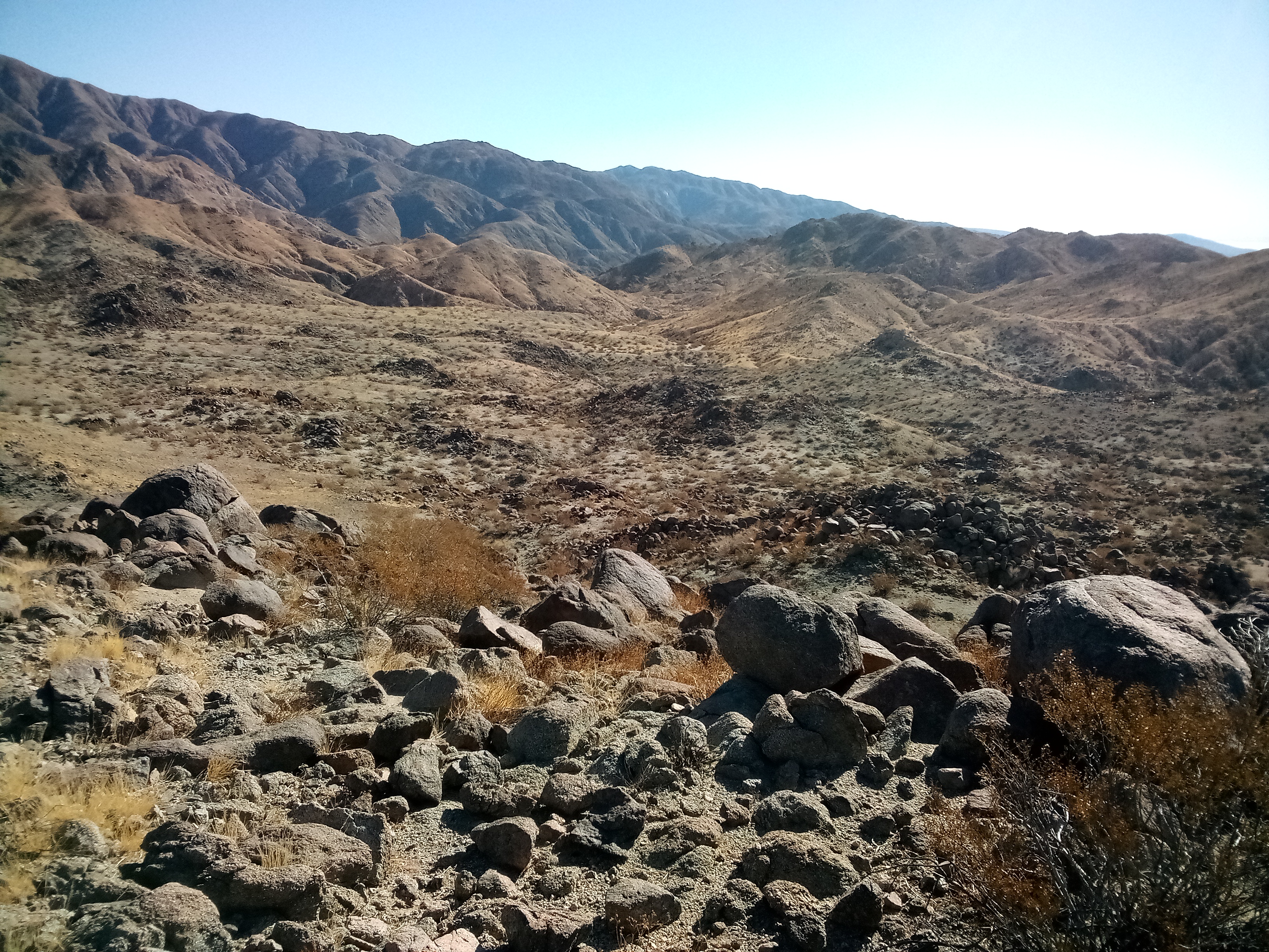
⦁ RIDGE CANYON is what I call the one between Rockhouse and Little Fargo. It's an easy loop up canyon then back on the west rim by way of Ridge BM. 4wds make it to the 1600 line in the canyon. Just past there are slabs on the left bank that must be associated with aqueduct construction. It's mostly smooth sand up to a 15 foot fall at the 2760 line. A gully on the left is an easy bypass then shortly a second little fall is passed on the left. Then a third fall is class 4 but I chickened out and went left around it then up a minor chokestone and on to the east side of peak 3659. A left fork there leads to the rim south of that peak then no issues down to Ridge BM and then a huge marker above the aqueduct. The rim is easy on down to peak 2594 and then a SE ridge leads down to the slabs. More markers are on the ridge at the 2080 line. 5 hours, 20 minutes, 8 miles with 2140 gain according to the app but hardly any is steep. Posted 2024
⦁ HIGH FARGO BENCHMARK el 3051 is an easy loop out of Fargo Canyon. I parked at the NW ridge reading N33 46139 , W116 04095 el 1700. I went up then down the north ridge to one of those huge markers over the aqueduct at 45519, 03379 el 2900. Then on down to 45693, 03304 el 2750 where I could either stay on the ridge down or move to the next one to my right. I chose the latter because I could see it. I hit bottom and strolled back. 3 hours, 15 minutes with 1500 gain. Posted 2024.
⦁ ROCKHOUSE CANYON - I walked up canyon then back over peak 4134. I parked a half mile up the canyon north of peak 2562 then walked up the main fork and took the fork that goes to the 22 on the topo. The fork turns south there toward the peak then at the 3800 line I got on the right rim and on up to the summit. The reg there was placed by M&L in 1980. The next party came in 1983 then the last in 1993. I kept going down the south ridge to N33 47299, W116 01664 el 3550 where I could see the rest. 4 hours, 21 minutes and 8.4 miles. The gain was 2150 but all easy but for the last 200 up the peak. Sissy drivers can park near Low Fargo BM and it will only add a mile each way. Posted 2024.
⦁ LITTLE FARGO CANYON makes a good loop up canyon then back on west ridges. I followed the main road into Fargo Canyon as shown on the topo then followed obvious tracks leading into Little Fargo. I parked at the main fork near point 1539. It's easy 4wd that far. I walked up the right fork to a narrows at the 1960 line where a 15 foot fall stops vehicles. A class 3 rock ladder on the left is easier than it looks. I went up canyon to a guzzler that explained why I was seeing a million sheep tracks. 4 young sheep carcasses where there. I went on up canyon and took the fork along the east side of peak 3135 then up a ridge at N33 48718, W116 05719 el 2900. At the 3400 line I dropped down to the main ridge then stayed right of the first two bumps then left of a third large one and on to the west saddle of peak 3182 reading 48732, 06868 el 3100. I stayed on top of the ridge weaving boulders and it soon got easier and then on to the descent ridge at 48689, 07351 el 3000. A handy sheep trail at 48360, 07249 el 2600 to the right of center makes it easy to go on another fifth mile where I dropped right down a ridge into a basin. I call it Bern Basin. I followed smooth sand down that and had one class 3 fall 15 feet high. I scooted down that on my butt then strolled on to the start. 5 hours, 8 miles with 2100 gain and hardly ever steep. ALTERNATE - another idea here would be to use Ridge Canyon for a loop in the two canyons. Posted 2024.
⦁ BERN BENCHMARK is on the west rim of Little Fargo. I made a good loop by parking at the 1160 line and walking up Little Fargo and then up the fork that goes into Bern Basin north of the peak. I went up a little peak on the rim of the basin for a view at N33 47906, W116 07444. I came back down the wash and thru a minor saddle at 47544, 06925 then up to a saddle on the right to get on the main rim and walked it over the BM then on down the rim to the start. Nearly 4 hours and maybe 200 noticeable gain. Easy. The basin is the prettiest area around. Posted 2024.
⦁ INDIO HILLS HIGH POINT has a jeep road all the way, but I made a hike out of it by walking up the road then down the long south ridge. At the junction of Dillon and Fargo roads, there is a dirt road heading west to the huge power lines. The southern road along the lines is the better one. At tower #27 there is a sandy roading cutting right that goes thru the hills. The reading there is N33 45062, W116 11259. Stay left at a main fork to get to the east side of the ridge. I parked north of peak 552 then walked the road up to the summit then back down the south ridge on a spotty trail. At 46069, 11611 I dropped down a gully back to the start. 3 hours, 1200 noticeable gain. The jeep road is steep but not eroded. I saw ebike tracks all the way to where I parked. NORTH RIDGE ROUTE - the Macomber Palms hike starts out up the north ridge of the peak and that's a shorter way up. Posted 2024.
⦁ BERDOO CANYON ROAD - this starts out as old pavement then at 1.3 miles in from Dillon Rd it drops into a wash. I call that spot the shooting gallery. Shooters have targets in the wash and they shoot in every direction. That lasts a quarter mile. Segments of driveable pavement have survived beyond there until the last segment on the left at point 1558 which is only wide enough for two wheelers. 4 wheelers stay right around it. The first tricky spot is at the 1900 line then at the 3400 line the road splits. The one on the right bank is the lesser of evils. Soon after that is the last tricky spot at a gooseneck then no issues to where the road tops out next to peak 4791. I stopped there, 10.5 miles in. I could have rode an ebike that far. Stock 4wds have no problem with this road. The aqueduct construction camp was just above the 1600 line. It had a hospital. Count on shooters 24/7 as far as the park boundary. I heard a machine gun one night. Cycle riders should wear a bulletproof vest and armored helmet. I put info on peakbagger on the map for Little Berdoo BM. Posted 2024.
⦁ WEST BERDOO CANYON is a smooth one that makes a good one way hike. I parked on the Berdoo road at a gully reading N33 49334, W116 10191 el 1250. I went up that then over to the main wash at 49523, 10645 el 1400. I went up staying left at main forks to the SE saddle of Push BM. I left my pack there and went up to the summit and back then down the ridge toward Center BM then on down to Dillon Rd to a pole near the 1000 line where I had my bike stashed. 2 hours, 40 minutes with 1300 gain. Only the last 500 to the peak is steep and that can be skipped. Posted 2024.
⦁ INDIO CANYON is smooth sand most of the way. I did a loop up canyon then back on the rim but the hike has to be started at dawn before shooters show up. I parked on the Berdoo Canyon road where it dips into the main wash a bit over a mile in from Dillon Rd. I walked downstream a third mile to an abandoned road going over the rim into Indio. I strolled up canyon and had some minor class 2 falls but at the 2600 line there is one 7 feet high bordering on class 4. I got up it OK then on to the saddle south of peak 3255. I walked up the rim on a sheep trail that levels off along the left side of the peak then went on to a deep saddle el 2150 near Berdoo Adit 1. I dropped down the drainage there on the left bank reading N33 49413, W116 08924 and then about halfway down moved right on smoother ground and hit the Berdoo road at the 1640 line. A bike there saves a 2 mile walk back. That took 5 hours, 8 miles with 2600 gain but 2000 is up the easy canyon. Those stats are just the hiking part and don't include the bike shuttle. Going one way from the 2640 line in Berdoo Canyon then over into Indio and down the canyon to Dillon Rd would avoid shooter risk but not entirely. A bullet fired at an optimal angle could hit Indio and the gravel plant and Dillon Rd. That would be a 7 mile hike and I would take a hook and line for that tricky fall. That's a pristine canyon. Posted 2024
⦁ PEAK 4717 is on the north rim of Berdoo Canyon. I made a loop up the east canyon then down the SE ridge. I parked on the Berdoo road at the 1900 line where there is a bad spot. I walked up the road and took a left fork at N33 50198, W116 07802 el 2100. I followed the forks that go to the 34 on the topo. At el 2700 there is a narrows with 2 tricky falls about 8 feet high. I barely made it up but there is a chicken route around the right on a mine road. I kept going up past the 34 then up to the saddle el 3950 on the main ridge. I followed a sheep trail up to the 4400 line then angled right to a trail at 51973, 08543 el 4500 and that got me around a peak to the last saddle. The reg was placed by M&L in 1981. I went down the SE ridge that leads to point 3056 then at el 3400 I could see an easy ridge going down to the right. I dropped down it to the main wash then down to a drop at the 2200 line. I backed up a little then up a minor class 3 gully to get on the south rim then went back down at the base of the fall and strolled on out. 5 hours, 8 miles and 2800 gain but the first 2000 is up easy washes. Posted 2024.
⦁ LITTLE BERDOO BENCHARK el 5400+ has easy routes but the scenic route is up the SW canyons and ridges. I parked on the Berdoo road at the return canyon el 2100. Lacking a shuttle, I walked on up the road over a mile to canyon at N33 49979, W116 06664 el 2500 and went up that to 50796, 05399 el 3850 where a steep ridge took me up to the rim. I followed a spotty sheep trail on up to the summit then on to peak 5238. I dropped down a ridge there reading 52149, 06048 el 5150 and walked down thru point 4620 then at el 3250 a crag is in the way. Sheep go along the right side and then the easiest looking route bends left to 50827, 07217 el 2650 where a trail drops left to the wash then on back to the road. 7 hours, 11 miles with 3700 gain but the first 1700 is up easy washes. An ebike shuttle would save over a mile. I put a track on peakbagger. Posted 2024.
- DECEPTION BENCHMARK el 3241 - I went one way up the south canyon to the NW saddle then over the summit. I parked on the Thousand Palms Rd near the locked gate near BM 1494 then coasted back down for a mile and a half and walked to N33 52826, W116 17987. That got me around the north side of private land and around a point then I strolled up the mostly smooth canyon that runs east of peak 2460 and into the saddle. Then I had easy ridges over the summit and down to the gate. That took 4 hours, 18 minutes and 7 miles with 2300 gain. The first 1600 is up the easy canyon. Reversing this would mean starting 500 higher but the strain gain would be more than double. But you could walk washes to the north saddle of peak 3098 then up the ridge. No shuttle required for that version. Posted 2025
- STUBBE SPRING LOOP - this is a long but easy one up canyon from the Thousand Palms Rd then down the south ridge of peak 4477. People are driving around the locked gate near BM 1494 but an ebike is the best option. The road to the Hidden Gold Mine is closed but easy to walk. I just walked up canyon then wanted to take the fork with a prospect but it's a disaster. I stayed in the easy main wash to N33 57848, W116 15304 just before the 3800 line then up a gully on the right to follow the rim up 300 feet to a flat. Then I leveled off above the prospect and dropped in just up stream of it. Then I followed the topo into the fork with the springs. I had to drop down a steep gully. The southern spring has a thicket and water some of the time. A camera was set up there. I went on to the defunct guzzler then to a trail at 57596, 13826. It goes a mile then turns left but I stayed straight in washes to the rim at 56196, 12646 then down and over the right side of peak 5102 then down to peak 4477. There is an option there to take the wash down past the mine. It would add 2 miles but likely just as fast. Instead I went over to the south ridge of the peak at 55559, 13235 el 4300 and walked it down. A crag at the 3640 line is passed on the right. 9 and a half hours, 16.5 miles with nearly 4000 gain. 3000 of that is easy, firm washes. I put a track on peakbagger under peak 4354 which is a mile and a half SW of the spring. Posted 2025
- PEAK 3543 is south of the Hidden Gold Mine. I came in the same way as the Stubbe Spring hike but there is an option to come in from the end of Hotwell Rd but it's 2 miles of bumpy little rocks. I walked the mine road around to the north side of the peak and took a road up to point 3219. Then I went over the summit and ran the ridge almost to peak 3042. It turns rocky there so I dropped down a ridge on the right and walked a wash toward a road going to a radio tower. Just before the road I took a right fork then the next left but it's blocked. So I just followed the main wash on along the north side of the park boundary and picked the easiest ridge down to the start. 5 hours, 10 miles and less than 1000 noticeable gain. A really pleasant hike. Posted 2025
- HIDDEN GOLD MINE LOOP - it's an easy loop to walk the road to the mine then come back on the west rim of the canyon. The road fades about where the topo shows then it's an easy wash walk to the mine. I walked under the mine and couldn't see anything so whatever is there can't be very interesting. I resumed up the main wash to the 4120 line then stepped up to the rim and walked toward peak 4038 and dropped down at N33 55040, W116 12378. I went down to a mine shaft at 54823, 12442 el 3640 and looked back and saw another mine 200 feet back that I passed by and didn't notice. I went on to the final ridge at 54684, 12544 el 3400 and down to the start. 5 hours, 10.5 miles with 2600 gain and all but 100 or so is up easy washes. Rocks weren't an issue until the lower part of the final ridge. The best way to get at the mine road is an ebike as in the Stubbe Spring hike. Hotwell Rd is less appealing due to rocks. Posted 2025
⦁ TIMS LADDER TRAIL is a steep one going up from Sky Valley Resort. It goes to Wide BM then on to a minor peak el 3100. I went up and came down East Deception Canyon but it's easier to reverse it. Drive to the resort on Dillon Rd then go west another tenth mile and park at a gate. Then ride an ebike east on Dillon to Gemini and go north on that to a T. Go right a short way to a gate. Walk on past the gate a tenth mile then to avoid rocks head for N33 54219, W116 19864 then on to the road and up canyon to peak 2669. It's way easier to take the wash on the north side of the peak and get into the NW saddle then go up ridge to the east of peak 3584 and then it goes north of the peak. Get into a canyon there at 57115, 20124 and go down it a quarter mile or so where it's easy to get on the west rim. Then just stay on the high ridge all the way to Wide BM. The trail starts at 56024, 21097 el 3100 and hits bottom at 54577, 21610 el 1100 and easy to follow. Rocks aren't an issue until below Wide BM where the trail turns rocky. 5 hours, 45 minutes, 10 miles with 1000 gain up the ridge and then minor ups and downs on the high ridge to Wide BM. SHORT VERSION - try going up West Deception along the east side of peak 3327 then into the north saddle and then come back on the high ridge. Or even easier, go up East Wide Canyon then take the fork running to point 2755. Posted 2024.
⦁ EAST WIDE CANYON is an easy one to make loop hikes. I went up then back in East Deception. The road into East Deception is gated but Gemini is the next road west and it can be taken to the end then a right turn soon leads to another gate el 1320. I parked there then rode my bike to Dillon Rd then west to Wide Canyon Rd. That road ends then I went right for a block to Aqueduct Rd then took that to a fence. Hikers go around the fence at the far left end. I strolled on up canyon and saw hiker tracks as far as the 2240 line. I took the fork running past point 2909 then on to peak 3605. I took a fork there running SE to the saddle which is south of peak 4128. It reads N33 58380, W116 19824 el 3850. I went down and soon hit a minor drop but a gully on the right gets past it. Then I had smooth sand down to the main canyon. At a main fork el 2800 there was an odd mud flow coming down the east arm and it coated the wash the rest of the way. I got on the right bank at 55639, 19179 for smoother walking and eventulally merged with the road. At the 1440 line I veered off the road thru 54219, 19864 then stayed left of rocks to get out. 6 hours, 45 minutes and 15 miles. I hardly even noticed the 2500 gain. But I did get a workout on the 6 mile bike shuttle. Posted 2024
⦁ LONG CANYON has dirt bike trails. A graded road goes up canyon to a gate at the 1600 line. Bikes go around that and I saw tracks on the sat image all the way to peak 4100. Another trail goes over Blind BM into Blind Canyon. No dirt bike? Then forget it. Posted 2025
- SHORT BENCHMARK el 3361 is east of Long Canyon. Cars can park in the canyon where a right fork goes up along the east side of Slid BM. Ebikes can make it up the fork to the park boundary then it's an easy wash up to the north side of Short BM. Then just go over the summit and down the west ridge and along the right side of a hill at N33 58122, W116 25130 then on down the main ridge to the start. 3 hours and 300 noticeable gain. Smooth washes and ridges. Who could ask for more? A few feet up the wash from the park boundary is a peculiar memorial nailed to the cliff on the left. Posted 2025